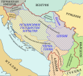
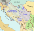
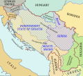
File:1941-1943 Axis occupation of Yugoslavia map - ru.svg
From Wikimedia Commons, the free media repository
Jump to navigation
Jump to search

Size of this PNG preview of this SVG file: 657 × 599 pixels. Other resolutions: 263 × 240 pixels | 526 × 480 pixels | 842 × 768 pixels | 1,123 × 1,024 pixels | 2,246 × 2,048 pixels | 1,613 × 1,471 pixels.
Original file (SVG file, nominally 1,613 × 1,471 pixels, file size: 2.89 MB)
File information
Structured data
Captions
Captions
Add a one-line explanation of what this file represents
Summary
[edit]| Description1941-1943 Axis occupation of Yugoslavia map - ru.svg |
English: Map of Yugoslavia under Axis occupation in 1941-1943 (in Russian). Русский: Карта Югославии, оккупированной фашистской Германией и ее союзниками в 1941-1943 гг. (на русском языке). |
| Date | |
| Source | Own work |
| Author | Hellerick |
| Other versions |
[edit]
|
Licensing
[edit]I, the copyright holder of this work, hereby publish it under the following license:
This file is licensed under the Creative Commons Attribution-Share Alike 3.0 Unported license.
- You are free:
- to share – to copy, distribute and transmit the work
- to remix – to adapt the work
- Under the following conditions:
- attribution – You must give appropriate credit, provide a link to the license, and indicate if changes were made. You may do so in any reasonable manner, but not in any way that suggests the licensor endorses you or your use.
- share alike – If you remix, transform, or build upon the material, you must distribute your contributions under the same or compatible license as the original.
File history
Click on a date/time to view the file as it appeared at that time.
| Date/Time | Thumbnail | Dimensions | User | Comment | |
|---|---|---|---|---|---|
| current | 07:20, 17 February 2014 |  | 1,613 × 1,471 (2.89 MB) | Hellerick (talk | contribs) | Krk annexed by Italy. |
| 02:39, 12 February 2014 |  | 1,613 × 1,471 (2.9 MB) | Hellerick (talk | contribs) | + maritime boundaries | |
| 03:26, 31 July 2013 |  | 1,613 × 1,471 (977 KB) | Hellerick (talk | contribs) | More contrast; wording | |
| 05:35, 30 July 2013 |  | 1,613 × 1,471 (974 KB) | Hellerick (talk | contribs) | Part of Greece annexed by Bulgaria. | |
| 04:35, 30 July 2013 |  | 1,613 × 1,471 (976 KB) | Hellerick (talk | contribs) | Smoots shape, clipping bug | |
| 04:29, 30 July 2013 |  | 1,613 × 1,471 (977 KB) | Hellerick (talk | contribs) | Clipping bug | |
| 04:19, 30 July 2013 |  | 1,613 × 1,471 (975 KB) | Hellerick (talk | contribs) | User created page with UploadWizard |
You cannot overwrite this file.
File usage on Commons
The following 14 pages use this file:
- User:Hellerick/1941-1943 Axis occupation of Yugoslavia maps
- File:1941-1943 Axis occupation of Yugoslavia map-hu.svg
- File:1941-1943 Axis occupation of Yugoslavia map.svg
- File:1941-1943 Axis occupation of Yugoslavia map - en.svg
- File:1941-1943 Axis occupation of Yugoslavia map - es.svg
- File:1941-1943 Axis occupation of Yugoslavia map - hr.svg
- File:1941-1943 Axis occupation of Yugoslavia map - ru.svg
- File:1941-1943 Axis occupation of Yugoslavia map - sr.svg
- File:2차 대전 기간 알바니아의 지도.png
- File:Map of Albania during WWII-CS.png
- File:Map of Albania during WWII-IT.png
- File:Map of Albania during WWII.png
- File:Map of Albania during Worl War 2.png
- Template:Other versions/Map of Albania during WWII
File usage on other wikis
The following other wikis use this file:
- Usage on ru.wikipedia.org
Metadata
This file contains additional information such as Exif metadata which may have been added by the digital camera, scanner, or software program used to create or digitize it. If the file has been modified from its original state, some details such as the timestamp may not fully reflect those of the original file. The timestamp is only as accurate as the clock in the camera, and it may be completely wrong.
| Width | 1612.9688 |
|---|---|
| Height | 1471.4688 |
Structured data
Items portrayed in this file
depicts
30 July 2013
image/svg+xml
4a1ada548bf578f2de29f9803144d529de10f412
3,034,667 byte
1,471 pixel
1,613 pixel
Categories:
- Maps of the Axis occupation of Yugoslavia
- Maps of Serbia during World War II
- Maps of Montenegro during World War II
- Maps of the Independent State of Croatia
- Maps of World War II in Slovenia
- Maps of the history of Banat
- Banat (1941-1944)
- Russian-language SVG maps showing history
- Operation Wildsau (1943)
- Operation Ozren
Hidden categories:


