File:(Peta Lokasi) Desa Mbinalun, Sitellu Tali Urang Jehe, Pakpak Bharat.svg
Jump to navigation
Jump to search

Size of this PNG preview of this SVG file: 510 × 600 pixels. Other resolutions: 204 × 240 pixels | 408 × 480 pixels | 653 × 768 pixels | 871 × 1,024 pixels | 1,742 × 2,048 pixels | 512 × 602 pixels.
Original file (SVG file, nominally 512 × 602 pixels, file size: 140 KB)
Captions
Captions
Add a one-line explanation of what this file represents

|
This file was moved to Wikimedia Commons from id.wikipedia using a bot script. All source information is still present. It requires review. Additionally, there may be errors in any or all of the information fields; information on this file should not be considered reliable and the file should not be used until it has been reviewed and any needed corrections have been made. Once the review has been completed, this template should be removed. For details about this file, see below. Check now! |
_Desa_Mbinalun,_Sitellu_Tali_Urang_Jehe,_Pakpak_Bharat.svg&action=edit&withJS=MediaWiki:Botcheck.js)
Summary
[edit]_Desa_Mbinalun,_Sitellu_Tali_Urang_Jehe,_Pakpak_Bharat.svg&action=edit§ion=1)
| Description |
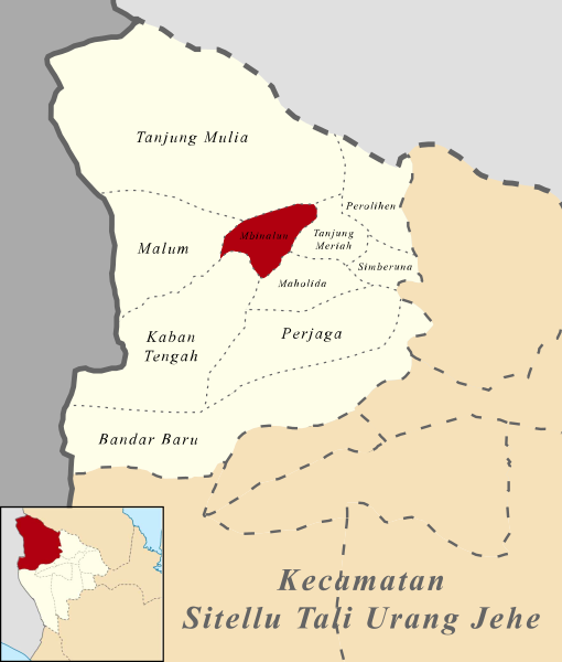
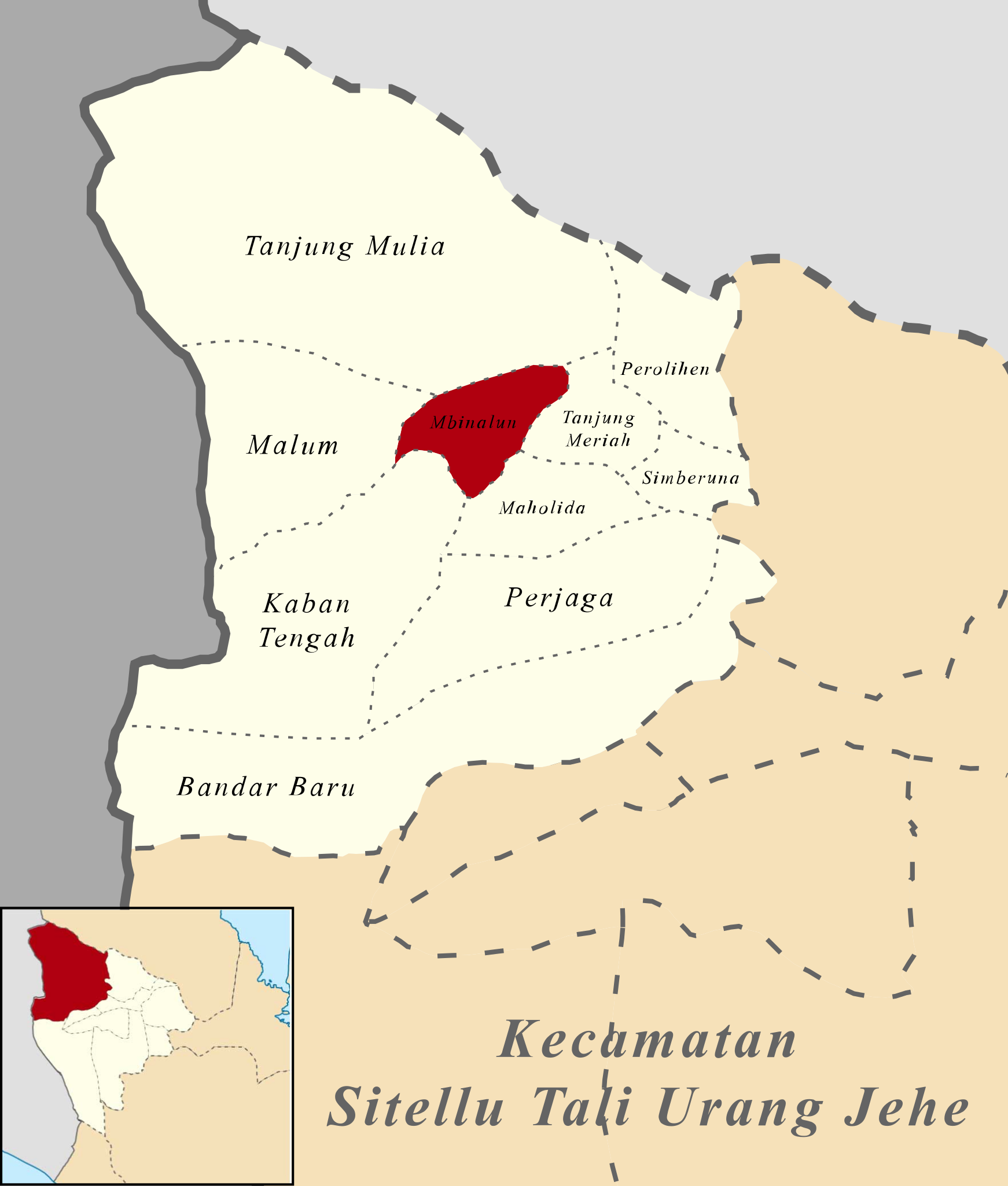
Bahasa Indonesia: (Peta Lokasi) Desa Mbinalun, Sitellu Tali Urang Jehe, Pakpak Bharat |
| Date | 22 August 2016 (original upload date) |
| Source |
Own work based on the map in Pakpak Bharat Regency Office Pakpak Bharat Regency official website Pakpak Bharat Statistics |
| Author | Christian Advs Sltg |
Licensing
[edit]_Desa_Mbinalun,_Sitellu_Tali_Urang_Jehe,_Pakpak_Bharat.svg&action=edit§ion=2)
I, the copyright holder of this work, hereby publish it under the following license:
This file is licensed under the Creative Commons Attribution-Share Alike 4.0 International license.
- You are free:
- to share – to copy, distribute and transmit the work
- to remix – to adapt the work
- Under the following conditions:
- attribution – You must give appropriate credit, provide a link to the license, and indicate if changes were made. You may do so in any reasonable manner, but not in any way that suggests the licensor endorses you or your use.
- share alike – If you remix, transform, or build upon the material, you must distribute your contributions under the same or compatible license as the original.
Original upload log
[edit]_Desa_Mbinalun,_Sitellu_Tali_Urang_Jehe,_Pakpak_Bharat.svg&action=edit§ion=3)
The original description page was here. All following user names refer to id.wikipedia.
| Date/Time | Dimensions | User | Comment |
|---|---|---|---|
| 2016-08-22 08:08 | 512×602× (143193 bytes) | 27christian11 | Peta Lokasi Mbinalun Kecamatan Sitellu_Tali_Urang_Jehe Kebupaten Pakpak Bharat [[Kategori:Peta penunjuk posisi di Indonesia]] |
File history
Click on a date/time to view the file as it appeared at that time.
| Date/Time | Thumbnail | Dimensions | User | Comment | |
|---|---|---|---|---|---|
| current | 11:59, 28 December 2017 | | 512 × 602 (140 KB) | 27christian11 (talk | contribs) | Transferred from id.wikipedia |
You cannot overwrite this file.
File usage on Commons
There are no pages that use this file.
File usage on other wikis
The following other wikis use this file:
- Usage on id.wikipedia.org
_Desa_Mbinalun,_Sitellu_Tali_Urang_Jehe,_Pakpak_Bharat.svg&oldid=734351593)