File:Îles d'Hyères topographic map-fr.svg
Jump to navigation
Jump to search

Size of this PNG preview of this SVG file: 784 × 337 pixels. Other resolutions: 320 × 138 pixels | 640 × 275 pixels | 1,024 × 440 pixels | 1,280 × 550 pixels | 2,560 × 1,100 pixels.
Original file (SVG file, nominally 784 × 337 pixels, file size: 1.84 MB)
Captions
Captions
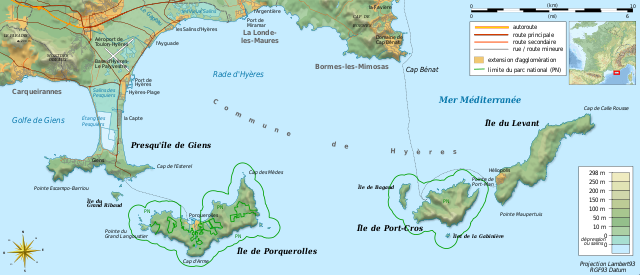
Topographic and administrative map of Îles d'Hyères
Summary
[edit]| Camera location | | View this and other nearby images on: OpenStreetMap |
|---|
| Description |
Français : Carte topographique et administrative en français des Îles d'Hyères.
Deutsch: Topographische Karte / Verwaltungskarte zum Îles d'Hyères, in Französische
English: Topographic and administrative map in French language of Îles d'Hyères
Italiano: Carta topografica e amministrativa delle Isole di Hyères (en francese)
|
||
| Date | (UTC) | ||
| Source |
Création personnelle ;
|
||
| Author | Bourrichon (talk) - fr:Bourrichon | ||
| Permission (Reusing this file) |
|
||
| Other versions |
Add-your-version : Template:Other versions/Îles d'Hyères map
|


|
This SVG file contains embedded text that can be translated into your language, using any capable SVG editor, text editor or the SVG Translate tool. For more information see: About translating SVG files. |
This W3C-unspecified vector image was created with Inkscape .
Licensing
[edit]
I, the copyright holder of this work, hereby publish it under the following licenses:

|
Permission is granted to copy, distribute and/or modify this document under the terms of the GNU Free Documentation License, Version 1.2 or any later version published by the Free Software Foundation; with no Invariant Sections, no Front-Cover Texts, and no Back-Cover Texts. A copy of the license is included in the section entitled GNU Free Documentation License. |
This file is licensed under the Creative Commons Attribution-Share Alike 3.0 Unported, 2.5 Generic, 2.0 Generic and 1.0 Generic license.
- You are free:
- to share – to copy, distribute and transmit the work
- to remix – to adapt the work
- Under the following conditions:
- attribution – You must give appropriate credit, provide a link to the license, and indicate if changes were made. You may do so in any reasonable manner, but not in any way that suggests the licensor endorses you or your use.
- share alike – If you remix, transform, or build upon the material, you must distribute your contributions under the same or compatible license as the original.
You may select the license of your choice.
File history
Click on a date/time to view the file as it appeared at that time.
| Date/Time | Thumbnail | Dimensions | User | Comment | |
|---|---|---|---|---|---|
| current | 11:40, 23 August 2018 | | 784 × 337 (1.84 MB) | Bourrichon (talk | contribs) | +extension des limites du parc national : ajout de l'île de Porquerolles |
| 13:53, 19 August 2011 |  | 784 × 337 (1.83 MB) | Bourrichon (talk | contribs) | == {{int:filedesc}} == {{Location|20|15|00|S|57|35|00|E|scale:500000}} {{Information |Description= {{fr|Carte topographique et administrative en français des Îles d'Hyères.}} {{de|Topographische Karte / Verwaltungskarte zum [[: |
You cannot overwrite this file.
File usage on Commons
The following 5 pages use this file:
File usage on other wikis
The following other wikis use this file:
- Usage on cs.wikipedia.org
- Usage on da.wikipedia.org
- Usage on de.wikipedia.org
- Usage on en.wikipedia.org
- Usage on en.wikivoyage.org
- Usage on fr.wikipedia.org
- Conservatoire du littoral
- Parc national de Port-Cros
- Presqu'île de Giens
- Îles d'Hyères
- Utilisateur:Flappiefh/Bac à sable/Images à améliorer/Contenu visiteur
- Wikipédia:Atelier graphique/Cartes/Archives/septembre 2011
- Rade d'Hyères
- Wikipédia:Atelier graphique/Cartes/Archives/octobre 2016
- Golfe de Giens
- Usage on fr.wiktionary.org
- Usage on ja.wikipedia.org
- Usage on la.wikipedia.org
- Usage on nn.wikipedia.org
- Usage on oc.wikipedia.org
- Usage on pl.wikipedia.org
- Usage on pt.wikipedia.org
- Usage on ru.wikipedia.org
- Usage on www.wikidata.org
- Usage on zh.wikipedia.org
- Usage on zh.wikivoyage.org