Commons:Wiki4Alps/Entremont

From Wikimedia Commons, the free media repository
Jump to navigation Jump to search

<< Wiki4Alps << Valais

List of the cultural heritage of the district of Entremont in the Canton Valais

[edit]
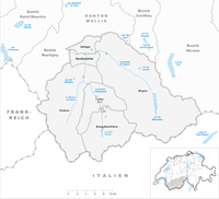
Map of Entremont
Map of Entremont

List of Monuments in the district of Entremont in the Canton Valais.

Update: 15 April 2014

List

[edit]
KGS-Nr Upload Foto   Object Other Cov. Cat. Type Address Town Coordinates
6604 Upload a file Alpage de Louvie No images A G Mauvoisin Bagnes
46° 03′ 07.45″ N, 7° 18′ 30.74″ E Kartographer map based on OpenStreetMap.View all coordinates using: OpenStreetMapinfo


6603 Upload a file Église St-Maurice, ossuaire, ancienne cure Église St-Maurice, ossuaire, ancienne cure No images A G Chemin de l’Église, Le Châble Bagnes
46° 04′ 49.37″ N, 7° 12′ 32.15″ E Kartographer map based on OpenStreetMap.View all coordinates using: OpenStreetMapinfo


13908 Upload a file Alpage de la Lia No images B G Mauvoisin Bagnes
45° 59′ 05.71″ N, 7° 20′ 43.66″ E Kartographer map based on OpenStreetMap.View all coordinates using: OpenStreetMapinfo


13909 Upload a file Alpage de Vasevay No images B G Mauvoisin Bagnes
46° 01′ 10.38″ N, 7° 20′ 35.09″ E Kartographer map based on OpenStreetMap.View all coordinates using: OpenStreetMapinfo


13910 Upload a file Alpage du Crêt No images B G Mauvoisin Bagnes
46° 01′ 45.66″ N, 7° 20′ 05.78″ E Kartographer map based on OpenStreetMap.View all coordinates using: OpenStreetMapinfo


13911 Upload a file Alpage du Giétro No images B G Mauvoisin Bagnes
45° 59′ 18.71″ N, 7° 21′ 29.66″ E Kartographer map based on OpenStreetMap.View all coordinates using: OpenStreetMapinfo


6613 Upload a file Ancien pont No images B G Mauvoisin Bagnes
46° 00′ 20.84″ N, 7° 20′ 31.92″ E Kartographer map based on OpenStreetMap.View all coordinates using: OpenStreetMapinfo


6608 Upload a file Le Cotterg - Fontaine du village Le Cotterg - Fontaine du village No images B K Chemin du Four, Le Châble Bagnes
46° 05′ 06.97″ N, 7° 12′ 39.17″ E Kartographer map based on OpenStreetMap.View all coordinates using: OpenStreetMapinfo


8744 Upload a file Musée des glaciers à Lourtier No images B S Chemin Jean-Pierre Perraudin 9, Lourtier Bagnes
46° 02′ 56.72″ N, 7° 15′ 57.31″ E Kartographer map based on OpenStreetMap.View all coordinates using: OpenStreetMapinfo


10691 Upload a file Musée de la pierre ollaire à Champsec No images B S Chemin des Fontaines 8, Champsec Bagnes
46° 03′ 24.34″ N, 7° 14′ 36.28″ E Kartographer map based on OpenStreetMap.View all coordinates using: OpenStreetMapinfo


10692 Upload a file Scie et moulin de Sarreyer No images B S Chemin du Moulin 1, Sarreyer Bagnes
46° 03′ 50.47″ N, 7° 15′ 01.04″ E Kartographer map based on OpenStreetMap.View all coordinates using: OpenStreetMapinfo


10693 Upload a file Forge Oreiller No images B G Chemin des Condémines 1, Le Châble Bagnes
46° 04′ 59.84″ N, 7° 12′ 37.26″ E Kartographer map based on OpenStreetMap.View all coordinates using: OpenStreetMapinfo


6648 Upload a file Église Saint-Pierre avec tour romane Église Saint-Pierre avec tour romane No images A G Rue de l’Église Bourg-Saint-Pierre
45° 56′ 57.01″ N, 7° 12′ 29.16″ E Kartographer map based on OpenStreetMap.View all coordinates using: OpenStreetMapinfo


6649 Upload a file Hospice du Grand Saint-Bernard avec ses dépendances Hospice du Grand Saint-Bernard avec ses dépendances No images A G Grand Saint-Bernard Bourg-Saint-Pierre
45° 52′ 08.44″ N, 7° 10′ 14.3″ E Kartographer map based on OpenStreetMap.View all coordinates using: OpenStreetMapinfo


8828 Upload a file Hospice du Grand Saint-Bernard, Archives No images A S Grand Saint-Bernard Bourg-Saint-Pierre
45° 52′ 08.08″ N, 7° 10′ 13.66″ E Kartographer map based on OpenStreetMap.View all coordinates using: OpenStreetMapinfo


9315 Upload a file Hospice du Grand Saint-Bernard, Bibliothèque No images A S Grand Saint-Bernard Bourg-Saint-Pierre
45° 52′ 08.18″ N, 7° 10′ 13.33″ E Kartographer map based on OpenStreetMap.View all coordinates using: OpenStreetMapinfo


8719 Upload a file Hospice du Grand Saint-Bernard, Musée No images A S Grand Saint-Bernard Bourg-Saint-Pierre
45° 52′ 07.9″ N, 7° 10′ 14.34″ E Kartographer map based on OpenStreetMap.View all coordinates using: OpenStreetMapinfo


6652 Upload a file Ancien prieuré No images B G Rue du Bourg 54 Bourg-Saint-Pierre
45° 56′ 56.15″ N, 7° 12′ 29.09″ E Kartographer map based on OpenStreetMap.View all coordinates using: OpenStreetMapinfo


6651 Upload a file Ancien hôpital No images B G Rue de l’Hôpital 6 Bourg-Saint-Pierre
45° 56′ 55.5″ N, 7° 12′ 30.89″ E Kartographer map based on OpenStreetMap.View all coordinates using: OpenStreetMapinfo


6654 Upload a file Chapelle Notre-Dame de Lorette No images B G Croix-Dessous Bourg-Saint-Pierre
45° 57′ 30.78″ N, 7° 12′ 35.03″ E Kartographer map based on OpenStreetMap.View all coordinates using: OpenStreetMapinfo


6655 Upload a file Le 2 Maisons dites de Challant No images B G Rue de la Laiterie Bourg-Saint-Pierre
45° 56′ 58.7″ N, 7° 12′ 28.08″ E Kartographer map based on OpenStreetMap.View all coordinates using: OpenStreetMapinfo


6656 Upload a file Moulin sur le torrent de Valsorey No images B G Prêt du Pont Bourg-Saint-Pierre
45° 56′ 50.28″ N, 7° 12′ 32.33″ E Kartographer map based on OpenStreetMap.View all coordinates using: OpenStreetMapinfo


6825 Upload a file Les Moulins Les Moulins No images A G Route de Fornex Liddes
46° 00′ 15.77″ N, 7° 10′ 04.91″ E Kartographer map based on OpenStreetMap.View all coordinates using: OpenStreetMapinfo


6827 Upload a file Chapelle Saint-Étienne No images B G Chemin de Loutze Liddes
45° 59′ 14.03″ N, 7° 11′ 20.33″ E Kartographer map based on OpenStreetMap.View all coordinates using: OpenStreetMapinfo


6828 Upload a file Maison Bastian No images B G Rue du Fond de Ville 30 Liddes
45° 59′ 30.98″ N, 7° 11′ 08.38″ E Kartographer map based on OpenStreetMap.View all coordinates using: OpenStreetMapinfo


10447 Upload a file Jardin botanique alpin Flore-Alpe Jardin botanique alpin Flore-Alpe No images A G Champex Orsières
46° 02′ 06.76″ N, 7° 06′ 15.23″ E Kartographer map based on OpenStreetMap.View all coordinates using: OpenStreetMapinfo


6920 Upload a file Archives bourgeoisiales et communales No images B S Rue de la Commune 3 Orsières
46° 01′ 48.83″ N, 7° 08′ 46.5″ E Kartographer map based on OpenStreetMap.View all coordinates using: OpenStreetMapinfo


10577 Upload a file Hôtel du Grand-Combin No images B G Rue du Lac 2, Champex Orsières
46° 01′ 38.64″ N, 7° 07′ 14.59″ E Kartographer map based on OpenStreetMap.View all coordinates using: OpenStreetMapinfo


6926 Upload a file Maison à cheminée(Chanton de Reppaz) No images B G Rappaz Orsières
46° 02′ 03.98″ N, 7° 09′ 22.18″ E Kartographer map based on OpenStreetMap.View all coordinates using: OpenStreetMapinfo


6924 Upload a file Chapelle de Notre-Dame des Neiges No images B G Ferret Orsières
45° 54′ 59.44″ N, 7° 06′ 17.68″ E Kartographer map based on OpenStreetMap.View all coordinates using: OpenStreetMapinfo


6921 Upload a file Chapelle Saint-Eusèbe et site archéologique Chapelle Saint-Eusèbe et site archéologique No images B F/G Route de la Proz Orsières
46° 01′ 21.79″ N, 7° 08′ 18.28″ E Kartographer map based on OpenStreetMap.View all coordinates using: OpenStreetMapinfo


6928 Upload a file Sust No images B G Route de la Lise 1 Orsières
46° 01′ 40.3″ N, 7° 08′ 48.88″ E Kartographer map based on OpenStreetMap.View all coordinates using: OpenStreetMapinfo


6922 Upload a file Clocher de l'église Saint-Nicolas Clocher de l'église Saint-Nicolas No images B G Rue de l’Église Orsières
46° 01′ 52.1″ N, 7° 08′ 46.32″ E Kartographer map based on OpenStreetMap.View all coordinates using: OpenStreetMapinfo


6927 Upload a file 2 maisons peintes No images B G Som-la-Proz 146–148 Orsières
46° 01′ 07.61″ N, 7° 07′ 52.57″ E Kartographer map based on OpenStreetMap.View all coordinates using: OpenStreetMapinfo


6996 Upload a file Chapelle Saint-Jean et site archéologique No images B F/G Route de la Garde Sembrancher
46° 04′ 27.52″ N, 7° 08′ 59.32″ E Kartographer map based on OpenStreetMap.View all coordinates using: OpenStreetMapinfo


7000 Upload a file Maison Luder No images B G Rue Principale 26 Sembrancher
46° 04′ 42.28″ N, 7° 09′ 02.77″ E Kartographer map based on OpenStreetMap.View all coordinates using: OpenStreetMapinfo


7001 Upload a file Moulin d’Allèves No images B G Sembrancher
46° 04′ 45.26″ N, 7° 09′ 17.64″ E Kartographer map based on OpenStreetMap.View all coordinates using: OpenStreetMapinfo


6997 Upload a file Crettaz-Polet, site et nécropole préhistorique No images B F Crettaz-Polet Sembrancher
46° 04′ 38.03″ N, 7° 08′ 40.49″ E Kartographer map based on OpenStreetMap.View all coordinates using: OpenStreetMapinfo


6999 Upload a file Hôpital No images B G Rue du Collège Sembrancher
46° 04′ 43.46″ N, 7° 08′ 53.7″ E Kartographer map based on OpenStreetMap.View all coordinates using: OpenStreetMapinfo


6998 Upload a file Église Saint-Étienne (clocher) No images B G Rue de l’Église Sembrancher
46° 04′ 41.66″ N, 7° 09′ 01.84″ E Kartographer map based on OpenStreetMap.View all coordinates using: OpenStreetMapinfo


7210 Upload a file Église Saint-Martin No images B G Route du Levron Vollèges
46° 05′ 14.39″ N, 7° 10′ 08.29″ E Kartographer map based on OpenStreetMap.View all coordinates using: OpenStreetMapinfo


7209 Upload a file Deux maisons avec tour d'eclaier en façade No images B G Chemin de la Cotze Vollèges
46° 05′ 17.38″ N, 7° 10′ 04.19″ E Kartographer map based on OpenStreetMap.View all coordinates using: OpenStreetMapinfo