Commons:Featured picture candidates/File:Roussel, Paris, ses fauxbourgs et ses environs, 1731.jpg
Jump to navigation
Jump to search

Voting period is over. Please don't add any new votes.Voting period ends on 21 Sep 2017 at 16:01:49 (UTC)
Visit the nomination page to add or modify image notes.

- Category: Commons:Featured pictures/Non-photographic media/Maps
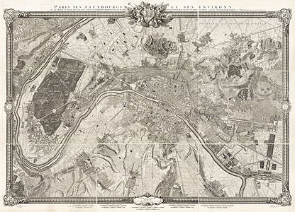
 Info created by Roussel - uploaded by Paris 16 - nominated by Paris 16 -- Paris 16 (talk) 16:01, 12 September 2017 (UTC)
 Support -- Paris 16 (talk) 16:01, 12 September 2017 (UTC)
- Support Wow. Great details, very good quality. Yann (talk) 16:14, 12 September 2017 (UTC)
 Neutral Got a 502 error; will try again later.
- You can see the original version on the LOC.--Paris 16 (talk) 06:14, 13 September 2017 (UTC)
- Support Wow! I bet those dots are individual blades of grass at this scale. Daniel Case (talk) 15:03, 13 September 2017 (UTC)
- You can see the original version on the LOC.--Paris 16 (talk) 06:14, 13 September 2017 (UTC)
- Support This is awesome - a really big full-size antique map of Paris. The scan is excellent, you can even see the flaws in the paper and each individual letter, pen stroke and line. :) --Peulle (talk) 07:05, 13 September 2017 (UTC)
- Support --Martin Falbisoner (talk) 13:02, 13 September 2017 (UTC)
- Support This one has crazy file size... Came from the future. -- Pofka (talk) 17:38, 14 September 2017 (UTC)
- Support --fedaro (talk) 21:58, 15 September 2017 (UTC)
Confirmed results:
This image will be added to the FP gallery: Non-photographic media/Maps