Commons:Featured picture candidates/File:Batad houses.jpg
Jump to navigation
Jump to search

File:Batad houses.jpg, featured
[edit]
Voting period is over. Please don't add any new votes.Voting period ends on 30 Jun 2023 at 15:48:02 (UTC)
Visit the nomination page to add or modify image notes.

- Gallery: Commons:Featured pictures/Places/Settlements
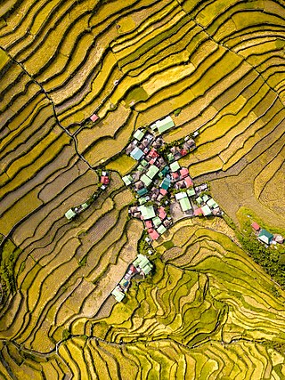
 Info A drone photo of the village of Batad in Banaue (Ifugao province, Philippines) with its famouse rice terraces; they are part of the UNESCO World Heritage site Rice Terraces of the Philippine Cordilleras. Created by Flickr user Vinnie Cartabiano – uploaded by Hariboneagle927 – nominated by --Aristeas (talk) 15:48, 21 June 2023 (UTC)
 Support Very different from our other current drone photo candidate, but also a photo with abstract beauty. The strong graphical contours of the rice terraces and the colour contrast between the yellowish paddy fields and the various pastel shades of the roofs make it special for me. The technical quality is good for a drone photo. --Aristeas (talk) 15:48, 21 June 2023 (UTC)
- Support I fully agree with Aristeas assessment. --Kritzolina (talk) 16:08, 21 June 2023 (UTC)
- Support -- Ivar (talk) 17:16, 21 June 2023 (UTC)
- Support --Frank Schulenburg (talk) 02:30, 22 June 2023 (UTC)
- Support --Ermell (talk) 05:34, 22 June 2023 (UTC)
- Support --LexKurochkin (talk) 05:52, 22 June 2023 (UTC)
 Oppose Sorry, but I'm not seeing anything exceptional here. 20 upper 08:40, 22 June 2023 (UTC)
- Support -- Radomianin (talk) 09:05, 22 June 2023 (UTC)
- Support -- Karelj (talk) 09:23, 22 June 2023 (UTC)
- Support --Llez (talk) 12:18, 22 June 2023 (UTC)
- Support Very educational and valuable. --SHB2000 (talk) 12:28, 22 June 2023 (UTC)
- Support --Uoaei1 (talk) 18:57, 22 June 2023 (UTC)
- Support --Schnobby (talk) 05:01, 23 June 2023 (UTC)
- Support -- That's quite good for a photo from the air,
clearly from an airplane or at least a high-flying helicopter (and I think an airplane)- no, from a drone that must have flown really high! -- Ikan Kekek (talk) 06:17, 23 June 2023 (UTC)
.jpg)
- Really high indeed, 1,100 metres (almost 10 times the legal limit of 120 metres in the Philippines), according to the EXIF metadata --Julesvernex2 (talk) 11:43, 24 June 2023 (UTC)
- The 1,100 metres are above sea level, right? According to the SRTM altitude data shown by OpenTopoMap the village itself is at about 810 metres above sea level and the highest parts of the visible area may even reach ~ 900 metres, so the difference is not that extreme. ;–) --Aristeas (talk) 15:23, 24 June 2023 (UTC)
- Fair point! From what I could gather, DJI drones record two altitudes in the EXIF data: GPSAltitude, relative to sea level, and RelativeAltitude, relative to the take-off point. However, there seems to be little consistency on how these are used e.g., on this, where the drone was flying below the take-off point, the recorded elevation is 3.9m below sea level for both fields :) This Batad image seems taken from more than 114m (RelativeAltitude) but less than 1,100m (GPSAltitude), so not sure if any of these fields is trustworthy... --Julesvernex2 (talk)
_julesvernex2.jpg)
- Support Poco a poco (talk) 23:02, 24 June 2023 (UTC)
- Support -- Johann Jaritz (talk) 04:54, 25 June 2023 (UTC)
- Support Nice patterns -- Basile Morin (talk) 04:13, 26 June 2023 (UTC)
- Support --XRay 💬 17:57, 26 June 2023 (UTC)
- Support 😄 ArionEstar 😜 23:39, 27 June 2023 (UTC)
- Support Daniel Case (talk) 04:43, 28 June 2023 (UTC)
Confirmed results:
This image will be added to the FP gallery: Places/Settlements