Category:Worsley
Jump to navigation
Jump to search
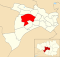
English: Worsley is situated in the Salford City Council ward of Worsley in the City of Salford
suburb in City of Salford, Greater Manchester, UK | |||||
| Upload media | |||||
| Instance of | |||||
|---|---|---|---|---|---|
| Location | Salford, Greater Manchester, North West England, England | ||||
 | |||||
Subcategories
This category has the following 7 subcategories, out of 7 total.
Media in category "Worsley"
The following 149 files are in this category, out of 149 total.
-
150 153 The Green.jpg 4,000 × 2,664; 3.44 MB
-
A575 at Worsley Park Hotel - geograph.org.uk - 4684458.jpg 640 × 481; 54 KB
-
A580 near Old Clough Lane junction - geograph.org.uk - 5025315.jpg 1,024 × 576; 96 KB
-
A580, Worsley - geograph.org.uk - 5025345.jpg 640 × 360; 51 KB
-
All is safely gathered in - geograph.org.uk - 44085.jpg 640 × 480; 95 KB
-
Architecture; decorative iron gates at Worsley Hall, Lancash Wellcome V0024315.jpg 3,424 × 2,161; 2.96 MB
-
Barge under the bridge (8128279278).jpg 3,112 × 4,648; 3.87 MB
-
Beesley Green - geograph.org.uk - 3403705.jpg 1,024 × 682; 686 KB
-
Beesley Green, Worsley - geograph.org.uk - 5353263.jpg 2,784 × 1,568; 2.18 MB
-
Bridge at Worsley (8128251349).jpg 4,622 × 3,086; 3.13 MB
-
Bridge at Worsley (8128278266).jpg 3,092 × 4,628; 5.55 MB
-
Bridge over Worsley Loop Line - geograph.org.uk - 3403800.jpg 1,024 × 682; 662 KB
-
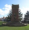
Bridgewater Memorial, Worsley Green - geograph.org.uk - 6401909.jpg 1,966 × 2,000; 3.7 MB
-
Broadoak Park - geograph.org.uk - 6501150.jpg 5,866 × 3,911; 1.76 MB
-
Buttercup Meadow - Worsley Woods - geograph.org.uk - 4533543.jpg 4,608 × 3,076; 3.52 MB
-
Car Park at Worsley Garden Centre - geograph.org.uk - 4004647.jpg 4,608 × 3,456; 6.5 MB
-
Claude Street - geograph.org.uk - 5632453.jpg 1,280 × 1,044; 1.02 MB
-
Cogs ! (8125457684).jpg 3,092 × 4,628; 1.82 MB
-
Cogs ! (8125458124).jpg 3,092 × 4,628; 1.86 MB
-
Cogs ! (8125458456).jpg 3,116 × 4,652; 1.7 MB
-
Cottages on Mill Brow, Worsley - geograph.org.uk - 3403894.jpg 1,024 × 682; 513 KB
-
Down to the canal - geograph.org.uk - 1530582.jpg 475 × 640; 152 KB
-
Earl of Ellesmere's memorial monument - geograph.org.uk - 31780.jpg 640 × 480; 101 KB
-
East Lancashire Road - geograph.org.uk - 46780.jpg 640 × 480; 71 KB
-
East Lancashire Road - geograph.org.uk - 5518391.jpg 1,280 × 960; 1.3 MB
-
East Lancashire Road - geograph.org.uk - 5518403.jpg 1,280 × 1,004; 1 MB
-
Edenfield Lane - geograph.org.uk - 5942978.jpg 6,000 × 4,000; 7.81 MB
-
Fields around Moss Colliery rd from footbridge over M60 - panoramio.jpg 7,445 × 3,191; 8.19 MB
-
Flush Bracket at Worsley Library.jpg 3,024 × 4,032; 3.35 MB
-
Footpath at Wardley - geograph.org.uk - 5735320.jpg 6,000 × 4,000; 5.85 MB
-
Footpath at Wardley - geograph.org.uk - 5735324.jpg 5,640 × 3,760; 7.48 MB
-
Footpath under the motorway - geograph.org.uk - 3403917.jpg 1,024 × 682; 642 KB
-
Golf Course - geograph.org.uk - 6509820.jpg 4,032 × 2,769; 1.89 MB
-
Granary Lane - geograph.org.uk - 5631537.jpg 1,280 × 830; 787 KB
-
Grange Road, Worsley - geograph.org.uk - 1381400.jpg 640 × 480; 230 KB
-
Grave of Polly - Mother of over 200 pigs - geograph.org.uk - 5275878.jpg 1,836 × 3,264; 1.41 MB
-
Greenleach Lane, Broadoak - geograph.org.uk - 2285065.jpg 640 × 480; 244 KB
-
Hastings Road, Worsley - geograph.org.uk - 1381399.jpg 640 × 480; 276 KB
-
Hazel Close, Egerton Park - geograph.org.uk - 2601161.jpg 640 × 480; 118 KB
-
Hazelhurst Road Telephone Box - geograph.org.uk - 1381371.jpg 640 × 480; 226 KB
-
Horse Pasture and Pylon Base Wardley - geograph.org.uk - 1905300.jpg 4,224 × 3,168; 5.77 MB
-
Is this a canal^ - geograph.org.uk - 4861206.jpg 800 × 600; 197 KB
-
Kempnough Brook - Worsley Woods - geograph.org.uk - 4533547.jpg 4,393 × 3,301; 3.55 MB
-
Leigh Road looking west in Worsley - geograph.org.uk - 3320707.jpg 640 × 480; 87 KB
-
Level Crossing - geograph.org.uk - 44859.jpg 640 × 480; 125 KB
-
Looking over Old Warke Dam to The Aviary - geograph.org.uk - 6401906.jpg 2,000 × 1,500; 2.11 MB
-
M60 motorway worsley.jpg 3,504 × 2,336; 1.97 MB
-
M60 Underpass, Worsley - geograph.org.uk - 5353151.jpg 2,784 × 1,568; 2.07 MB
-
M60, Eccles, Manchester - geograph.org.uk - 44102.jpg 640 × 480; 75 KB
-
Manchester Road (A6) at the M60 Bridge - geograph.org.uk - 6106694.jpg 1,600 × 1,200; 448 KB
-
New Alder Park - geograph.org.uk - 5942992.jpg 6,000 × 4,000; 7.38 MB
-
New Alder Park - geograph.org.uk - 5943001.jpg 6,000 × 4,000; 4.72 MB
-
Overflow at Worsley Dam - geograph.org.uk - 3403899.jpg 1,024 × 682; 661 KB
-
Part of The Green, Worsley - geograph.org.uk - 5213576.jpg 6,000 × 4,000; 5.64 MB
-
Path behind the dam, Worsley - geograph.org.uk - 1759403.jpg 2,376 × 4,224; 2.29 MB
-
Petasites Hybridus At Beesley Green - geograph.org.uk - 2285517.jpg 960 × 1,280; 918 KB
-
Phone box, Worsley - geograph.org.uk - 1530613.jpg 424 × 640; 157 KB
-
Port Salford Greenway - geograph.org.uk - 5942973.jpg 6,000 × 4,000; 5.41 MB
-
Road through St Mary's Catholic Cemetery - geograph.org.uk - 5735317.jpg 6,000 × 4,000; 7.21 MB
-
Road to St Mary's RC Cemetery - geograph.org.uk - 2906486.jpg 640 × 480; 189 KB
-
Roadworks on Manchester Road - geograph.org.uk - 5728112.jpg 5,396 × 3,597; 7 MB
-
Roe Green Cricket Club - Pavilion - geograph.org.uk - 3439028.jpg 1,600 × 1,200; 355 KB
-
Roe Green Cricket Club - Scoreboard - geograph.org.uk - 3439043.jpg 640 × 480; 86 KB
-
Sanderson's Sidings - geograph.org.uk - 2285388.jpg 640 × 480; 288 KB
-
Sculpture - geograph.org.uk - 6501064.jpg 3,851 × 5,040; 1.77 MB
-
Spring Colour On The Green - geograph.org.uk - 2285028.jpg 1,280 × 960; 912 KB
-
St John Vianney, Wardley Catholic Cemetery.JPG 1,536 × 2,048; 1.34 MB
-
St Mary's RC Cemetery, Wardley - geograph.org.uk - 5735292.jpg 6,000 × 4,000; 4.83 MB
-
Summer roses - panoramio.jpg 3,008 × 2,000; 1.7 MB
-
Sun light through the trees (8125438041).jpg 3,092 × 4,628; 2.1 MB
-
Telephone box (8125437713).jpg 4,628 × 2,025; 1,010 KB
-
Terraced Cottages, Worsley - geograph.org.uk - 1381377.jpg 640 × 480; 225 KB
-
The Aviary, Worsley - geograph.org.uk - 6401907.jpg 2,000 × 1,370; 2.43 MB
-
The East Lancs Road - geograph.org.uk - 5735304.jpg 5,727 × 3,817; 4.46 MB
-
The Grange, Winton, Eccles - geograph.org.uk - 44096.jpg 640 × 480; 93 KB
-
The Green - geograph.org.uk - 5631402.jpg 1,280 × 960; 1.19 MB
-
The Green, Worsley - geograph.org.uk - 3291334.jpg 4,320 × 3,240; 2.95 MB
-
The Green, Worsley - geograph.org.uk - 5213571.jpg 6,000 × 4,000; 6.53 MB
-
The Loopline - geograph.org.uk - 2285503.jpg 640 × 480; 346 KB
-
The Mews - Worsley - geograph.org.uk - 6043463.jpg 768 × 1,024; 115 KB
-
The third tee - geograph.org.uk - 4861207.jpg 800 × 600; 140 KB
-
The Tyldesley to Worsley Loopline - geograph.org.uk - 6746565.jpg 1,816 × 4,032; 1.34 MB
-
The Village Green - geograph.org.uk - 49731.jpg 640 × 480; 73 KB
-
The Village Green - geograph.org.uk - 49733.jpg 640 × 480; 78 KB
-
The Worsley to Tyldesley Loopline - geograph.org.uk - 6746563.jpg 4,032 × 1,816; 1.54 MB
-
Traffic outside Worsley Methodist Church - geograph.org.uk - 2079792.jpg 4,592 × 3,056; 3.72 MB
-
Trees on the green ! (8130276397).jpg 3,092 × 4,628; 1.28 MB
-
Wake up Worsley ! (8130304836).jpg 4,608 × 3,072; 1.16 MB
-
Wardley Wood - geograph.org.uk - 5735300.jpg 5,640 × 3,760; 7.65 MB
-
Water Pumping Station - geograph.org.uk - 6693601.jpg 4,032 × 1,816; 1.47 MB
-
Weather vane on Granary Lane - geograph.org.uk - 5631613.jpg 1,280 × 1,470; 890 KB
-
Welcome sign on Bridgewater Road - geograph.org.uk - 2476599.jpg 1,600 × 1,198; 245 KB
-
Welcome to Worsley, City of Salford - geograph.org.uk - 4834318.jpg 3,072 × 1,728; 1.37 MB
-
Where can I park^ - geograph.org.uk - 949906.jpg 640 × 412; 64 KB
-
Wooded Path and Cycle Track - geograph.org.uk - 2300802.jpg 1,280 × 960; 1.29 MB
-
Woodland near Wardley Hall - geograph.org.uk - 5728145.jpg 6,000 × 4,000; 6.7 MB
-
Worsley (6526602677).jpg 3,240 × 4,320; 4.99 MB
-
Worsley (6526606401).jpg 3,240 × 4,320; 4.63 MB
-
Worsley (6526609001).jpg 3,240 × 4,320; 5.07 MB
-
Worsley (6526611291).jpg 3,240 × 4,320; 5.2 MB
-
Worsley (6526615739).jpg 4,320 × 3,240; 4.73 MB
-
Worsley (6526619909).jpg 3,240 × 4,320; 4.57 MB
-
Worsley (6526620761).jpg 4,320 × 3,240; 3.78 MB
-
Worsley (6526621961).jpg 3,240 × 4,320; 5.02 MB
-
Worsley (6526623189).jpg 3,240 × 4,320; 4.79 MB
-
Worsley (6526624435).jpg 3,240 × 4,320; 4.54 MB
-
Worsley (6526625611).jpg 3,240 × 4,320; 4.75 MB
-
Worsley (6526626923).jpg 3,240 × 4,320; 4.16 MB
-
Worsley (6526627619).jpg 4,320 × 3,240; 3.27 MB
-
Worsley (6526628727).jpg 2,859 × 4,320; 4.14 MB
-
Worsley (6526629807).jpg 3,240 × 4,320; 4.86 MB
-
Worsley (6526630357).jpg 3,240 × 4,320; 2.09 MB
-
Worsley (6526631931).jpg 3,240 × 4,320; 5.24 MB
-
Worsley (6526633021).jpg 3,240 × 4,320; 5.19 MB
-
Worsley (6526634221).jpg 4,320 × 3,240; 5.65 MB
-
Worsley (6526635405).jpg 3,240 × 4,320; 5.2 MB
-
Worsley (Salford City Council ward).png 2,000 × 1,902; 302 KB
-
Worsley - The Aviary ^ Old Warke Dam - geograph.org.uk - 6409323.jpg 5,184 × 2,920; 5.53 MB
-
Worsley Brook - geograph.org.uk - 44118.jpg 640 × 480; 122 KB
-
Worsley Cricket Club - Pavilion - geograph.org.uk - 3004907.jpg 1,600 × 1,200; 363 KB
-
Worsley Cricket Club - Scoreboard - geograph.org.uk - 3004909.jpg 1,600 × 1,200; 347 KB
-
Worsley Delph, Gtr Manchester (461592) (9453075603).jpg 3,240 × 4,320; 3.42 MB
-
Worsley Green (8126941831).jpg 3,092 × 4,628; 1.36 MB
-
Worsley Green (8126941931).jpg 3,092 × 4,628; 1.13 MB
-
Worsley Green (8128253295).jpg 4,628 × 3,092; 3.9 MB
-
Worsley Green, Gtr Manchester (461593) (9455861346).jpg 4,320 × 3,240; 3.91 MB
-
Worsley Green, Gtr Manchester (461594) (9453085533).jpg 3,200 × 4,268; 4.24 MB
-
Worsley Green, Gtr Manchester (461595) (9455871058).jpg 4,268 × 3,200; 3.74 MB
-
Worsley Green, Gtr Manchester - panoramio (1).jpg 2,048 × 1,535; 939 KB
-
Worsley green.jpg 3,514 × 2,340; 6.64 MB
-
Worsley railway station.jpg 3,522 × 2,348; 3.39 MB
-
Worsley Rd View (8354083426).jpg 3,112 × 4,648; 3.75 MB
-
Worsley Road (8359209082).jpg 2,899 × 4,688; 3.9 MB
-
Worsley Road (8359209412).jpg 4,636 × 956; 833 KB
-
Worsley Road (A572) - geograph.org.uk - 1381372.jpg 640 × 480; 179 KB
-
Worsley Road - geograph.org.uk - 6501090.jpg 5,895 × 4,000; 1.81 MB
-
Worsley Road at Junction With Greenside - geograph.org.uk - 6971705.jpg 4,032 × 3,024; 4.1 MB
-
Worsley Road United Reformed Church - geograph.org.uk - 5212656.jpg 6,000 × 4,000; 4.03 MB
-
Worsley Urban District Council - coat of arms.png 256 × 346; 105 KB
-
Worsley ward.svg 2,000 × 2,000; 5 KB
-
Roe Green - geograph.org.uk - 49729.jpg 640 × 480; 83 KB


