Category:Wonersh
Jump to navigation
Jump to search
English: Wonersh is a small Surrey village in England. Wonersh is about 3 miles SSE of Guildford on the B2128 road from Guildford, Shalford to Cranleigh. Neighbouring villages include Bramley, Shamley Green and Blackheath.
village and civil parish in Surrey, UK  | |||||
| Upload media | |||||
| Instance of | |||||
|---|---|---|---|---|---|
| Location | Waverley, Surrey, South East England, England | ||||
| Population |
| ||||
| Area |
| ||||
 | |||||
Subcategories
This category has the following 9 subcategories, out of 9 total.
B
C
- Chinthurst Hill, Wonersh, Surrey (16 F)
G
- The Grantley Arms, Wonersh (8 F)
S
- St John's Seminary, Wonersh (7 F)
W
Media in category "Wonersh"
The following 200 files are in this category, out of 788 total.
(previous page) (next page)-
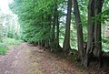
 A coppiced tree - geograph.org.uk - 3399616.jpg 640 × 430; 141 KB
-
 A large tree near Lostiford - geograph.org.uk - 3399548.jpg 640 × 430; 61 KB
-
 A tree by the Downs Link - geograph.org.uk - 2054335.jpg 640 × 430; 123 KB
-
 Alderbrook Rd - geograph.org.uk - 3137156.jpg 640 × 430; 88 KB
-
 Alderbrook Road, Winterfold Heath - geograph.org.uk - 4600619.jpg 2,560 × 1,920; 1.93 MB
-
 Alderbrook Road, Winterfold Heath - geograph.org.uk - 4600620.jpg 2,560 × 1,920; 1.93 MB
-

-

-

-
-

-

-

-

-
-

-

-

-

-

-

-
-

-
-

-

-

-

-

-

-

-

-
-

-

-

-

-

-
-
-

-
 Almost invisible footpath - geograph.org.uk - 2623079.jpg 768 × 1,024; 289 KB
-
 An ancient earthbank - geograph.org.uk - 3159257.jpg 640 × 430; 108 KB
-
 An empty car park - geograph.org.uk - 3424822.jpg 640 × 430; 92 KB
-
 Approaching Great Copse - geograph.org.uk - 2781744.jpg 4,288 × 3,216; 3.68 MB
-
 Arbuthnot Hall - geograph.org.uk - 3375850.jpg 640 × 430; 68 KB
-
 At Shamley Green on a May evening - geograph.org.uk - 4480858.jpg 1,024 × 770; 183 KB
-
 Avenue footpath - geograph.org.uk - 2623067.jpg 768 × 1,024; 301 KB
-
 B2128 - geograph.org.uk - 3377443.jpg 640 × 430; 55 KB
-
 B2128 - geograph.org.uk - 3414794.jpg 640 × 430; 79 KB
-
 B2128 - geograph.org.uk - 3414796.jpg 640 × 430; 100 KB
-
 B2128 enters Wonersh - geograph.org.uk - 3399599.jpg 640 × 430; 99 KB
-
 B2128, Cranleigh Rd - geograph.org.uk - 3399583.jpg 640 × 430; 67 KB
-
 B2128, Guildford Rd - geograph.org.uk - 3375825.jpg 640 × 395; 59 KB
-
 Badger Sett - geograph.org.uk - 3383322.jpg 640 × 430; 137 KB
-
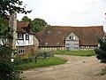 Barn at Great Tangley Manor Farm - geograph.org.uk - 2523831.jpg 3,648 × 2,736; 5.04 MB
-
 Barn, Derryswood Farm - geograph.org.uk - 3387301.jpg 640 × 432; 80 KB
-
 Barn, Great Tangley - geograph.org.uk - 3414666.jpg 640 × 430; 55 KB
-
 Barn, Great Tangley Manor Farm - geograph.org.uk - 3414673.jpg 640 × 430; 63 KB
-
 Barn, Great Tangley Manor Farm - geograph.org.uk - 3414677.jpg 640 × 430; 59 KB
-
 Barn, Great Tangley Manor Farm - geograph.org.uk - 3414681.jpg 640 × 419; 76 KB
-
 Barn, Great Tangley Manor Farm - geograph.org.uk - 3414683.jpg 640 × 430; 77 KB
-
 Barn, Great Tangley Manor Farm - geograph.org.uk - 4150723.jpg 2,048 × 1,536; 877 KB
-
 Barn, Mill Lodge - geograph.org.uk - 3399593.jpg 640 × 430; 108 KB
-
 Barn, Reelhall Hill - geograph.org.uk - 3380408.jpg 640 × 430; 48 KB
-
 Barnett Cottage - geograph.org.uk - 3785085.jpg 696 × 884; 298 KB
-
 Barnett Hill - geograph.org.uk - 624547.jpg 640 × 480; 163 KB
-
 Barnett Hill Lodge - geograph.org.uk - 3407681.jpg 640 × 430; 110 KB
-
 Barnett Hill viewed from south lawn - geograph.org.uk - 1137335.jpg 640 × 480; 74 KB
-
 Barnett Hill Wood - geograph.org.uk - 3399629.jpg 640 × 430; 49 KB
-
 Barnett Hill Wood - geograph.org.uk - 3399668.jpg 640 × 430; 51 KB
-
 Barnett Lane - geograph.org.uk - 3407725.jpg 640 × 430; 58 KB
-
 Barnett Lane, Wonersh - geograph.org.uk - 3785097.jpg 814 × 1,020; 378 KB
-
 Barnett Lane, Wonersh - geograph.org.uk - 4851967.jpg 2,048 × 1,536; 1.48 MB
-
 Bench at Blackheath - geograph.org.uk - 6192100.jpg 3,180 × 2,121; 7.52 MB
-
 Birches and conifers, Blackheath Common - geograph.org.uk - 5268668.jpg 743 × 1,024; 222 KB
-
 Blackheath - 1977 Jubilee - geograph.org.uk - 6721812.jpg 5,152 × 3,864; 6.59 MB
-
 Blackheath - Cricket Ground - geograph.org.uk - 5263650.jpg 2,560 × 1,920; 2.82 MB
-
 Blackheath - geograph.org.uk - 164350.jpg 640 × 480; 127 KB
-
 Blackheath - geograph.org.uk - 6192136.jpg 3,101 × 2,068; 7.78 MB
-
 Blackheath - geograph.org.uk - 6192154.jpg 3,578 × 2,386; 7.75 MB
-
 Blackheath - geograph.org.uk - 6192158.jpg 3,101 × 2,068; 7.74 MB
-
 Blackheath - geograph.org.uk - 6192330.jpg 3,657 × 2,439; 7.68 MB
-
 Blackheath - Parting of the Ways - geograph.org.uk - 6721815.jpg 5,152 × 3,864; 7.5 MB
-
 Blackheath - St Martin's Church - geograph.org.uk - 6721823.jpg 5,152 × 3,864; 5.15 MB
-
 Blackheath - The Villagers - geograph.org.uk - 6721831.jpg 3,864 × 5,152; 6.68 MB
-
 Blackheath - The Villagers - geograph.org.uk - 6721836.jpg 5,152 × 3,864; 4.35 MB
-
 Blackheath - VE Day 2020 - geograph.org.uk - 6721860.jpg 5,152 × 3,864; 7.08 MB
-
 Blackheath - VE Day 2020 - geograph.org.uk - 6721865.jpg 5,152 × 3,864; 5.14 MB
-
 Blackheath - VE Day 2020 - geograph.org.uk - 6721867.jpg 3,864 × 5,152; 6.48 MB
-
 Blackheath - War Memorial - geograph.org.uk - 6721848.jpg 5,152 × 3,864; 5.11 MB
-
 Blackheath - War Memorial - geograph.org.uk - 6721870.jpg 3,864 × 5,152; 6.14 MB
-
 Blackheath Common - geograph.org.uk - 186028.jpg 640 × 480; 169 KB
-
 Blackheath Common - geograph.org.uk - 186031.jpg 480 × 640; 181 KB
-
 Blackheath Common - geograph.org.uk - 2079898.jpg 640 × 430; 148 KB
-
 Blackheath Common - geograph.org.uk - 2079908.jpg 640 × 430; 143 KB
-
 Blackheath Common - geograph.org.uk - 2610703.jpg 640 × 480; 136 KB
-
 Blackheath Common - geograph.org.uk - 2903030.jpg 4,288 × 3,216; 3.4 MB
-
 Blackheath Common car park. - geograph.org.uk - 2523971.jpg 2,272 × 1,704; 2.99 MB
-
 Blackheath Common in January (1) - geograph.org.uk - 5268510.jpg 1,024 × 788; 133 KB
-
 Blackheath Common in January (2) - geograph.org.uk - 5268551.jpg 1,024 × 774; 304 KB
-
 Blackheath Cricket Club - geograph.org.uk - 4188402.jpg 2,816 × 2,112; 2.33 MB
-
 Blackheath Cricket Ground - geograph.org.uk - 6721755.jpg 5,152 × 3,864; 5.47 MB
-
 Blackheath Cricket Ground - geograph.org.uk - 6721778.jpg 5,152 × 3,864; 6.1 MB
-
 Blackheath Cricket Ground - geograph.org.uk - 6721799.jpg 3,864 × 5,152; 6.47 MB
-
 Blackheath Cricket Ground - geograph.org.uk - 6721802.jpg 5,152 × 3,864; 5.06 MB
-
 Blackheath Forest - geograph.org.uk - 6192174.jpg 2,942 × 1,962; 7.8 MB
-
 Blackheath Forest - geograph.org.uk - 6192179.jpg 3,180 × 2,121; 7.55 MB
-
 Blackheath Forest - geograph.org.uk - 6192184.jpg 3,180 × 2,121; 7.75 MB
-
 Blackheath Forest - geograph.org.uk - 6721710.jpg 5,152 × 3,864; 7.66 MB
-
 Blackheath Forest - geograph.org.uk - 6721721.jpg 5,152 × 3,864; 7.1 MB
-
 Blackheath Forest - geograph.org.uk - 6721745.jpg 5,152 × 3,864; 6.5 MB
-
 Blackheath Lane - geograph.org.uk - 2661529.jpg 640 × 428; 147 KB
-
 Blackheath Lane - geograph.org.uk - 3407682.jpg 640 × 430; 99 KB
-
 Blackheath Lane - geograph.org.uk - 3407695.jpg 640 × 430; 112 KB
-
 Blackheath Lane - geograph.org.uk - 3407697.jpg 640 × 430; 106 KB
-
 Blackheath Lane - geograph.org.uk - 3407701.jpg 640 × 430; 111 KB
-
 Blackheath Lane - geograph.org.uk - 3407703.jpg 640 × 430; 121 KB
-
 Blackheath Lane junction - geograph.org.uk - 4150264.jpg 2,048 × 1,536; 1.51 MB
-
 Blackheath Lane, Wonersh, in October - geograph.org.uk - 4218347.jpg 889 × 1,024; 307 KB
-
 Blackheath sign - geograph.org.uk - 2182484.jpg 2,816 × 1,880; 3.62 MB
-
-
 Blackheath, Lynes Farm - geograph.org.uk - 6122485.jpg 6,577 × 4,385; 5.84 MB
-
 Blackheath, view towards the car park - geograph.org.uk - 4218904.jpg 768 × 1,024; 212 KB
-
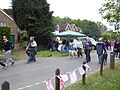
 Blooming Wonersh - geograph.org.uk - 1389690.jpg 640 × 480; 100 KB
-
 Bluebells in Cucknell's Wood Nature Reserve - geograph.org.uk - 4916894.jpg 4,782 × 1,253; 2.8 MB
-
 Board walk in Cucknells Wood - geograph.org.uk - 3261351.jpg 600 × 800; 224 KB
-
 Bridge across the Wey, Bramley - geograph.org.uk - 4846296.jpg 2,048 × 1,536; 1.56 MB
-
 Bridge at Run Common - geograph.org.uk - 5450340.jpg 1,024 × 768; 279 KB
-
 Bridge over the Downs Link, Run Common - geograph.org.uk - 2054260.jpg 640 × 430; 172 KB
-
 Bridge over the Downs Link, Run Common - geograph.org.uk - 2054267.jpg 640 × 430; 198 KB
-
 Bridle-way across Blackheath Common - geograph.org.uk - 5268660.jpg 1,024 × 788; 231 KB
-
 Bridleway - footpath junction - geograph.org.uk - 3383311.jpg 640 × 430; 129 KB
-
 Bridleway - geograph.org.uk - 3487021.jpg 640 × 430; 54 KB
-
 Bridleway access to Winterfold Cottage - geograph.org.uk - 2604850.jpg 1,024 × 768; 209 KB
-
 Bridleway across Blackheath Common - geograph.org.uk - 2079940.jpg 640 × 430; 173 KB
-
 Bridleway across Blackheath Common - geograph.org.uk - 2079959.jpg 640 × 430; 200 KB
-
 Bridleway along the ridge north of Woodhill Lane - geograph.org.uk - 2623077.jpg 1,024 × 768; 232 KB
-

-
 Bridleway in Blackheath Forest - geograph.org.uk - 2903021.jpg 4,288 × 3,216; 3.66 MB
-
 Bridleway known as Dibdene Lane - geograph.org.uk - 2623071.jpg 768 × 1,024; 285 KB
-
 Bridleway on Blackheath - geograph.org.uk - 2622298.jpg 768 × 1,024; 329 KB
-
 Bridleway on Blackheath Common - geograph.org.uk - 4211992.jpg 1,024 × 773; 162 KB
-
 Bridleway signpost on Littleford Lane - geograph.org.uk - 2255033.jpg 800 × 600; 201 KB
-
 Bridleway signpost, Blackheath Common - geograph.org.uk - 2079843.jpg 640 × 430; 149 KB
-
 Bridleway to Birtley Green - geograph.org.uk - 4852154.jpg 2,592 × 1,936; 2.16 MB
-
 Bridleway to Green Lane - geograph.org.uk - 3383324.jpg 640 × 430; 114 KB
-
 Bridleway to Reelhall Hill - geograph.org.uk - 3383343.jpg 640 × 430; 123 KB
-
 Bridleway to Shamley Green - geograph.org.uk - 3487000.jpg 640 × 430; 50 KB
-
 Bridleway, Blackheath Common - geograph.org.uk - 2079865.jpg 640 × 430; 152 KB
-
 Bridleway, Blackheath Common - geograph.org.uk - 2079880.jpg 640 × 430; 210 KB
-
 Bridleway, Hurtwood - geograph.org.uk - 3159255.jpg 640 × 430; 120 KB
-
 Bridleway, Reelhall Hill - geograph.org.uk - 3383306.jpg 640 × 418; 101 KB
-
 Bridleway, Reelhall Hill - geograph.org.uk - 3383320.jpg 640 × 430; 133 KB
-
 Bridleway, Tangley Hill - geograph.org.uk - 2211298.jpg 3,072 × 2,304; 2.65 MB
-
 Bus shelter, Blackheath Lane - geograph.org.uk - 3407712.jpg 640 × 430; 55 KB
-
 By bridleway 484 - geograph.org.uk - 2661504.jpg 640 × 480; 184 KB
-
 Byway reaches Row Lane - geograph.org.uk - 2604837.jpg 1,024 × 768; 277 KB
-
 Car Park entrance on Winterfold Heath - geograph.org.uk - 4688529.jpg 2,304 × 1,728; 2.34 MB
-
 Car park on Littleford Lane, Blackheath Common - geograph.org.uk - 4846093.jpg 2,048 × 1,536; 1.44 MB
-
 Cattle in field by Green Lane - geograph.org.uk - 2622311.jpg 1,024 × 746; 260 KB
-
 Chinthurst Hill car park - geograph.org.uk - 4086430.jpg 2,048 × 1,536; 1.29 MB
-
 Chinthurst Hill Jubilee Toposcope - geograph.org.uk - 3784967.jpg 3,872 × 2,592; 2.4 MB
-
 Chinthurst Hill Jubilee Toposcope and Folly - geograph.org.uk - 3784956.jpg 2,592 × 3,872; 2.29 MB
-
 Chinthurst Lodge - geograph.org.uk - 2240054.jpg 800 × 600; 127 KB
-
 Christmas Tree Plantation - geograph.org.uk - 2780732.jpg 4,288 × 3,216; 3.55 MB
-
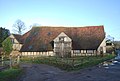
 Church House, Wonersh - geograph.org.uk - 1389675.jpg 640 × 480; 94 KB
-
 Cleared conifers on Winterfold Heath - geograph.org.uk - 4688487.jpg 2,304 × 1,728; 820 KB
-
 Cleared woodland, Blackheath Common - geograph.org.uk - 2610717.jpg 640 × 480; 125 KB
-
 Collapsed barn, Wonersh.jpg 3,456 × 2,304; 4.31 MB
-
 Colourful cow - geograph.org.uk - 4188435.jpg 2,816 × 2,112; 2.18 MB
-
 Conifer Woodland, Blackheath Common - geograph.org.uk - 2079872.jpg 640 × 430; 209 KB
-
 Coniferous Woodland, Blackheath Common - geograph.org.uk - 2079884.jpg 640 × 430; 209 KB
-
 Coniferous Woodland, Blackheath Common - geograph.org.uk - 2079931.jpg 640 × 430; 202 KB
-
 Coniferous Woodland, Blackheath Common - geograph.org.uk - 2079949.jpg 640 × 430; 208 KB
-
 Conifers, Blackheath Common - geograph.org.uk - 2079955.jpg 640 × 430; 190 KB
-
 Construction in South Copse - geograph.org.uk - 2780796.jpg 4,288 × 3,216; 3.64 MB
-
 Contrasting Trees - geograph.org.uk - 2781691.jpg 4,288 × 3,216; 3.66 MB
-
 Coppice by Bisney Cottage - geograph.org.uk - 1096676.jpg 640 × 480; 165 KB
-
 Coppiced tree by Dibdene Lane - geograph.org.uk - 3380395.jpg 640 × 430; 124 KB
-
 Coppiced tree by Dibdene Lane - geograph.org.uk - 3380399.jpg 640 × 430; 137 KB
-
 Coppiced tree by the Downs Link - geograph.org.uk - 2052799.jpg 640 × 430; 195 KB
-
 Coppicing - geograph.org.uk - 3399646.jpg 640 × 430; 122 KB
-
 Coppicing, Derry's Wood - geograph.org.uk - 3399664.jpg 640 × 430; 147 KB
-
 Cottage on Guildford Road, Stroud Common - geograph.org.uk - 4847122.jpg 2,048 × 1,536; 1.43 MB
-
 Cottage on Norley Lane, Shamley Green - geograph.org.uk - 4846294.jpg 1,960 × 1,412; 856 KB
-
 Cottage or outbuilding at the end of Green Lane - geograph.org.uk - 2599294.jpg 1,024 × 768; 192 KB
-
 Cottages, Shamley Green - geograph.org.uk - 3377452.jpg 640 × 430; 60 KB
-
 Cottages, Wonersh - geograph.org.uk - 663346.jpg 640 × 480; 87 KB
-
 Court House - geograph.org.uk - 3377453.jpg 640 × 430; 58 KB
-
 Court House - geograph.org.uk - 663355.jpg 640 × 480; 69 KB
-
 Cranleigh Rd - geograph.org.uk - 3399584.jpg 640 × 430; 92 KB
-
 Cranleigh Road, Shamley Green - geograph.org.uk - 2821968.jpg 1,600 × 1,200; 630 KB
-
 Cranleigh Road, Wonersh - geograph.org.uk - 2822678.jpg 1,600 × 1,200; 549 KB
-
 Cricket Green at Blackheath village - geograph.org.uk - 2623113.jpg 1,024 × 768; 164 KB
-
 Cricket square, Shamley Green - geograph.org.uk - 3377437.jpg 640 × 430; 57 KB
-
 Crossroads near Shamley Green - geograph.org.uk - 2198050.jpg 800 × 600; 146 KB
-
 Cucknell's Wood - geograph.org.uk - 4916866.jpg 4,296 × 885; 1.71 MB
-
 Cucknell's Wood - geograph.org.uk - 4916879.jpg 3,038 × 1,355; 1.81 MB
-
 Cucknell's Wood nature reserve - geograph.org.uk - 4916838.jpg 4,119 × 1,019; 1.71 MB


_-_geograph.org.uk_-_6143903.jpg)
_-_geograph.org.uk_-_6147749.jpg)
_-_geograph.org.uk_-_6147750.jpg)
_-_geograph.org.uk_-_6147751.jpg)
_-_geograph.org.uk_-_6147753.jpg)
_-_geograph.org.uk_-_6147754.jpg)
_-_geograph.org.uk_-_6147755.jpg)
_-_geograph.org.uk_-_6147756.jpg)
_-_geograph.org.uk_-_6147757.jpg)
_-_geograph.org.uk_-_6147758.jpg)
_-_geograph.org.uk_-_6147759.jpg)
_-_geograph.org.uk_-_6143907.jpg)
_-_geograph.org.uk_-_6147760.jpg)
_-_geograph.org.uk_-_6147761.jpg)
_-_geograph.org.uk_-_6147762.jpg)
_-_geograph.org.uk_-_6147763.jpg)
_-_geograph.org.uk_-_6147765.jpg)
_-_geograph.org.uk_-_6147766.jpg)
_-_geograph.org.uk_-_6147768.jpg)
_-_geograph.org.uk_-_6147770.jpg)
_-_geograph.org.uk_-_6147771.jpg)
_-_geograph.org.uk_-_6147772.jpg)
_-_geograph.org.uk_-_6143908.jpg)
_-_geograph.org.uk_-_6143911.jpg)
_-_geograph.org.uk_-_6147775.jpg)
_-_geograph.org.uk_-_6147776.jpg)
_-_geograph.org.uk_-_6147779.jpg)
_-_geograph.org.uk_-_6147780.jpg)
_-_geograph.org.uk_-_6143912.jpg)
_-_geograph.org.uk_-_6147726.jpg)
_-_geograph.org.uk_-_6147743.jpg)
_-_geograph.org.uk_-_6147744.jpg)
_-_geograph.org.uk_-_6147745.jpg)
_-_geograph.org.uk_-_6147746.jpg)


_-_geograph.org.uk_-_5268510.jpg)
_-_geograph.org.uk_-_5268551.jpg)


