Category:Winnersh
Jump to navigation
Jump to search
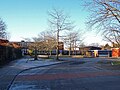
English: Winnersh is a village and civil parish, a part of Wokingham Borough, in the English county of Berkshire. The parish is roughly bounded on the north-east by the A329(M), to the north-west by the river Loddon, Old Forest Road and Simons Lane on the south east and Bearwood Road on the south-west. This also encompases the estate village of Sindlesham.
Nederlands: Winnersh is een dorp (village en civil parish) in het Engelse graafschap Berkshire. Het dorp ligt in het district Wokingham en telt 7.939 inwoners.
village in the United Kingdom  | |||||
| Upload media | |||||
| Instance of | |||||
|---|---|---|---|---|---|
| Location | Wokingham, Berkshire, South East England, England | ||||
| Population |
| ||||
 | |||||
Subcategories
This category has the following 5 subcategories, out of 5 total.
S
- Sindlesham Court (2 F)
W
- Winnersh railway station (2 F)
Media in category "Winnersh"
The following 160 files are in this category, out of 160 total.
-
 33 Arbor Lane, Winnersh - geograph.org.uk - 2306974.jpg 1,730 × 1,647; 2.62 MB
-
 6, Winnersh - geograph.org.uk - 4968797.jpg 640 × 426; 67 KB
-
 A busy Robin Hood Lane by Winnersh Station - geograph.org.uk - 3922347.jpg 1,500 × 999; 212 KB
-
 A Column on the Triangle - geograph.org.uk - 3892575.jpg 640 × 454; 55 KB
-
 A New School - geograph.org.uk - 3891886.jpg 2,415 × 1,575; 705 KB
-
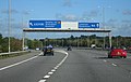
 A329 (M) eastbound - geograph.org.uk - 3342130.jpg 640 × 480; 41 KB
-
 A329 crosses Loddon Bridge - geograph.org.uk - 6372783.jpg 1,024 × 512; 185 KB
-
 A329 Reading Road, Winnersh - geograph.org.uk - 6372765.jpg 1,024 × 684; 225 KB
-
 A329(M) approaching the M4 - geograph.org.uk - 4744213.jpg 640 × 393; 38 KB
-
 A329(M) at the M4 junction - geograph.org.uk - 3718001.jpg 4,127 × 1,845; 1.49 MB
-
 A329(M) at Winnersh - geograph.org.uk - 4451132.jpg 800 × 497; 77 KB
-
 A329(M) just after junction 10 (M4) - geograph.org.uk - 3401245.jpg 640 × 425; 54 KB
-
 A329(M) slip road to eastbound M4 - geograph.org.uk - 5609008.jpg 640 × 428; 90 KB
-
 A3290 - geograph.org.uk - 4968818.jpg 640 × 426; 48 KB
-
 A3290 flyover, Winnersh - geograph.org.uk - 504095.jpg 640 × 480; 104 KB
-
 Albany Park Drive, Winnersh - geograph.org.uk - 4340460.jpg 2,560 × 1,920; 2.02 MB
-
 Albany Park Drive, Winnersh - geograph.org.uk - 4341469.jpg 2,560 × 1,920; 1.96 MB
-
 All gone now - geograph.org.uk - 1478362.jpg 640 × 462; 102 KB
-
 Arrows and Lines and Curves and Signs - geograph.org.uk - 3892563.jpg 2,495 × 1,785; 829 KB
-
 B3030 King Street Lane, Winnersh - geograph.org.uk - 6236217.jpg 1,024 × 684; 335 KB
-
 B3030 Robin Hood Lane, Winnersh - geograph.org.uk - 6236219.jpg 1,024 × 684; 359 KB
-
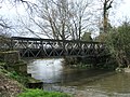 Bailey bridge across the River Loddon - geograph.org.uk - 4667882.jpg 1,600 × 1,200; 638 KB
-
 Barn conversion at Hatch Farm, Sindlesham - geograph.org.uk - 6489543.jpg 6,000 × 4,000; 5.72 MB
-
 Bathurst Road, Winnersh - geograph.org.uk - 2572358.jpg 1,600 × 1,200; 633 KB
-
 Bearwood Road, Sindlesham - geograph.org.uk - 6236213.jpg 1,024 × 684; 404 KB
-
 Beer garden, The George, Loddon Bridge - geograph.org.uk - 504339.jpg 640 × 480; 176 KB
-
 Benchmark on Arbor Lane railway bridge - geograph.org.uk - 4394476.jpg 1,024 × 683; 273 KB
-
 Benchmark on ^587 Reading Road - geograph.org.uk - 4394688.jpg 638 × 1,024; 160 KB
-
 Beneath a flyover at Winnersh Triangle - geograph.org.uk - 504122.jpg 480 × 640; 127 KB
-
 Borough of Wokingham , M4 Motorway - geograph.org.uk - 5725486.jpg 6,000 × 4,000; 6.06 MB
-
 Borough of Wokingham , M4 Motorway - geograph.org.uk - 5725490.jpg 6,000 × 4,000; 6.41 MB
-
 Borough of Wokingham , M4 Motorway - geograph.org.uk - 5725491.jpg 6,000 × 4,000; 6.24 MB
-
 Borough of Wokingham , M4 Motorway - geograph.org.uk - 5725492.jpg 6,000 × 4,000; 7.65 MB
-
 Borough of Wokingham , M4 Motorway - geograph.org.uk - 5725493.jpg 6,000 × 4,000; 6.02 MB
-
 Borough of Wokingham , M4 Motorway - geograph.org.uk - 5725494.jpg 5,750 × 3,834; 5.47 MB
-
 Borough of Wokingham , M4 Motorway - geograph.org.uk - 5725495.jpg 6,000 × 4,000; 6.02 MB
-
 Bus stop on Reading Road outside Sainsbury's - geograph.org.uk - 4389270.jpg 1,024 × 683; 146 KB
-
 Car wash on Reading Road, Winnersh - geograph.org.uk - 4340514.jpg 2,560 × 1,920; 1.98 MB
-
 Chatsworth Avenue, Winnersh - geograph.org.uk - 3912769.jpg 1,600 × 1,146; 300 KB
-
 Country Gardens head office - geograph.org.uk - 855745.jpg 640 × 345; 65 KB
-

-
 Davis Street Bridge, A329(M) - geograph.org.uk - 4744212.jpg 640 × 393; 37 KB
-
 Deerhurst Avenue, Winnersh - geograph.org.uk - 2334871.jpg 640 × 427; 98 KB
-
 Digging north of Forest Road - geograph.org.uk - 5777899.jpg 4,916 × 3,231; 4.77 MB
-
 Eastbound M4 at Junction 10 - geograph.org.uk - 4481150.jpg 640 × 480; 237 KB
-
 Farmland, Winnersh - geograph.org.uk - 1776101.jpg 640 × 480; 128 KB
-
 Farmland, Winnersh - geograph.org.uk - 1808876.jpg 640 × 480; 112 KB
-
 Farmland, Winnersh - geograph.org.uk - 4374983.jpg 640 × 480; 214 KB
-
 Field by Little Hill Road - geograph.org.uk - 3401248.jpg 640 × 424; 49 KB
-

-
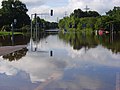
 Flooded car park, Loddon Bridge - geograph.org.uk - 504330.jpg 640 × 480; 139 KB
-
 Flooded house, Reading Road, Winnersh - geograph.org.uk - 504307.jpg 640 × 480; 184 KB
-
 Flooded junction on the A329, Winnersh - geograph.org.uk - 504304.jpg 640 × 480; 107 KB
-
 Focus DIY store, Winnersh - geograph.org.uk - 504312.jpg 640 × 480; 118 KB
-
 Footbridge - geograph.org.uk - 471824.jpg 640 × 475; 137 KB
-
 Footpath and old fence posts - geograph.org.uk - 1715774.jpg 1,704 × 2,272; 3.36 MB
-
 FORESTSIXTH EASTER2015.jpg 960 × 640; 75 KB
-

-
 Holiday Inn, Winnersh - geograph.org.uk - 3892522.jpg 2,127 × 1,755; 761 KB
-
 House at Winnersh Garden Centre - geograph.org.uk - 504327.jpg 640 × 480; 163 KB
-

-
 Houses on Reading Road, Winnersh - geograph.org.uk - 4340651.jpg 2,560 × 1,920; 2 MB
-
 J10 Overbridge, M4 - geograph.org.uk - 4812491.jpg 640 × 381; 37 KB
-
 J10 overbridge, M4 - geograph.org.uk - 5219405.jpg 640 × 426; 39 KB
-
 Joining the M4, westbound - geograph.org.uk - 4744217.jpg 640 × 393; 33 KB
-
 Junction 10 (A329(M)) of M4 - geograph.org.uk - 2672476.jpg 800 × 600; 323 KB
-
-
 Large field with silage bales - geograph.org.uk - 2495125.jpg 640 × 480; 84 KB
-
 Loddon Bridge - geograph.org.uk - 504337.jpg 640 × 480; 162 KB
-
 Loddon Bridge Reading Circus - geograph.org.uk - 5501354.jpg 1,163 × 764; 308 KB
-
 Loddon Lilly Winnersh.JPG 1,704 × 2,272; 708 KB
-
 Loddon Viaduct east bank.jpg 2,048 × 1,152; 768 KB
-
 Loddon Viaduct river span.jpg 2,048 × 1,152; 743 KB
-
 M4 (junct.10) joining the A329(M) - geograph.org.uk - 3401243.jpg 800 × 466; 77 KB
-
 M4 bridge carries A329(M) northbound carriageway - geograph.org.uk - 2570185.jpg 3,467 × 2,474; 961 KB
-
 M4 crossing Mill Lane, Sindlesham - geograph.org.uk - 6489503.jpg 6,000 × 4,000; 6.63 MB
-
 M4 eastbound - geograph.org.uk - 3883761.jpg 640 × 397; 32 KB
-
 M4 eastbound - geograph.org.uk - 3883766.jpg 640 × 498; 28 KB
-
 M4 Junction 10 eastbound - geograph.org.uk - 1995447.jpg 1,024 × 683; 205 KB
-
 M4 Junction10 - geograph.org.uk - 3883774.jpg 640 × 445; 47 KB
-

-
 M4 south of Earley, aerial 2014 - geograph.org.uk - 4036411.jpg 640 × 427; 59 KB
-
 M4 west of Junction 10 - geograph.org.uk - 3622606.jpg 2,478 × 1,429; 1.52 MB
-
 M4 westbound - geograph.org.uk - 3622633.jpg 2,023 × 1,239; 1.22 MB
-
 M4 westbound, 44 miles to Swindon - geograph.org.uk - 3622618.jpg 2,269 × 1,434; 1.48 MB
-
 M4, J10 - geograph.org.uk - 5219404.jpg 640 × 401; 42 KB
-
 M4, westbound - geograph.org.uk - 3649456.jpg 640 × 430; 32 KB
-
 M4, westbound - geograph.org.uk - 4744219.jpg 640 × 372; 34 KB
-
 M4, westbound - geograph.org.uk - 4812492.jpg 640 × 426; 50 KB
-
 M4, westbound - geograph.org.uk - 4812493.jpg 640 × 448; 39 KB
-
 M4, westbound - geograph.org.uk - 4812494.jpg 640 × 287; 34 KB
-
 Mabey Bailey bridge across the River Loddon - geograph.org.uk - 4681371.jpg 2,848 × 2,136; 1.59 MB
-
 Mabey Bailey bridge across the River Loddon - geograph.org.uk - 4683926.jpg 2,848 × 2,136; 1.57 MB
-
 Map, Mailbox ^ Holiday Inn - geograph.org.uk - 3892506.jpg 2,391 × 1,716; 653 KB
-
 Mill Lane runs under the M4 - geograph.org.uk - 5189787.jpg 1,500 × 1,125; 221 KB
-
 Mole Road in Sindlesham - geograph.org.uk - 5189786.jpg 1,500 × 1,109; 207 KB
-

-
 New housing on Green Lane - geograph.org.uk - 4389373.jpg 1,024 × 677; 179 KB
-
 Old Forest Road at the junction of Reading Road - geograph.org.uk - 4341484.jpg 2,560 × 1,920; 1.75 MB
-
 Old House down Primrose Lane - geograph.org.uk - 3891879.jpg 2,394 × 1,704; 983 KB
-
 Open space at Winnersh - geograph.org.uk - 1715502.jpg 2,272 × 1,704; 2.12 MB
-

-
 Post boxes by the fields - geograph.org.uk - 1715393.jpg 2,272 × 1,704; 1.96 MB
-
 Powerlines by the A329(M) - geograph.org.uk - 3399116.jpg 800 × 463; 55 KB
-
 Railway bridge RDG2 19-1388, Arbor Lane - geograph.org.uk - 4394496.jpg 1,024 × 683; 204 KB
-
 Railway line near Winnersh - geograph.org.uk - 3898120.jpg 4,320 × 3,240; 2.9 MB
-
 Rainbow Park, Winnersh - geograph.org.uk - 3912753.jpg 1,600 × 1,082; 410 KB
-
 Reading Road at the junction of Robinhood Lane - geograph.org.uk - 4340517.jpg 2,560 × 1,920; 1.98 MB
-
 Reading Road in Winnersh - geograph.org.uk - 3922319.jpg 1,500 × 999; 173 KB
-
 Reading Road in Winnersh - geograph.org.uk - 3922323.jpg 1,500 × 999; 154 KB
-
 Reading Road in Winnersh - geograph.org.uk - 3922333.jpg 1,500 × 999; 169 KB
-
 Reading Road, Winnersh - geograph.org.uk - 65905.jpg 640 × 481; 50 KB
-
 Reading to London railway arch Earley - geograph.org.uk - 5501358.jpg 1,015 × 635; 268 KB
-
 River Loddon - geograph.org.uk - 471822.jpg 640 × 475; 127 KB
-

-
 Roadworks, M4 - geograph.org.uk - 3356486.jpg 640 × 430; 30 KB
-
 Robin Hood Lane off Reading Road - geograph.org.uk - 3794278.jpg 1,500 × 999; 121 KB
-
 Robin Hood Lane to Twyford - geograph.org.uk - 3927755.jpg 1,500 × 999; 177 KB
-
 Sadler's Lane - geograph.org.uk - 1715748.jpg 2,272 × 1,704; 2.14 MB
-
 Sandford Lane, Hurst - geograph.org.uk - 504191.jpg 640 × 480; 175 KB
-
 Semi-detached houses on Reading Road - geograph.org.uk - 4394698.jpg 1,024 × 683; 202 KB
-
 Sindlesham Church - geograph.org.uk - 5502589.jpg 849 × 555; 205 KB
-
 Slip road M4 junction 10 - geograph.org.uk - 2299320.jpg 640 × 430; 61 KB
-
 Solid workers loo - geograph.org.uk - 3512055.jpg 800 × 476; 72 KB
-

-

-
 SU7870 - The Forest School, Winnersh.jpg 1,024 × 768; 786 KB
-
 Summer Court, Sindlesham - geograph.org.uk - 5778185.jpg 5,219 × 3,223; 2.43 MB
-
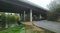
 The B3030 passes under the M4, Winnersh - geograph.org.uk - 6236216.jpg 1,024 × 684; 337 KB
-
 The Brooks Macdonald Oval - geograph.org.uk - 5778124.jpg 1,600 × 1,067; 342 KB
-
 The George, Earley, Reading - geograph.org.uk - 5501298.jpg 1,012 × 633; 240 KB
-
 The River Loddon - geograph.org.uk - 504333.jpg 640 × 480; 143 KB
-
 The Showcase Cinema, Winnersh - geograph.org.uk - 504297.jpg 640 × 480; 143 KB
-
 The Surelock McGill Oval - geograph.org.uk - 5778118.jpg 5,472 × 3,648; 3.24 MB
-
 The Winnersh Royal British Legion - geograph.org.uk - 1715489.jpg 2,272 × 1,704; 2.02 MB
-
 Trees on the Bridge - geograph.org.uk - 3892535.jpg 2,560 × 1,788; 885 KB
-
 Trees on the Bridge Again - geograph.org.uk - 3892550.jpg 2,560 × 1,920; 1.06 MB
-
 Turnstone Close, Winnersh - geograph.org.uk - 4340472.jpg 2,560 × 1,920; 1.98 MB
-
 Very large field seen from Sadler's Lane - geograph.org.uk - 1715763.jpg 2,272 × 1,704; 2.2 MB
-
 Welby Crescent, Winnersh - geograph.org.uk - 2334502.jpg 640 × 480; 140 KB
-
 Wharfedale Road, Winnersh Triangle - geograph.org.uk - 67824.jpg 640 × 481; 31 KB
-

-
 Windsor and Maidenhead , M4 Motorway - geograph.org.uk - 5726390.jpg 6,000 × 4,000; 5.98 MB
-
 Winnersh - geograph.org.uk - 3352.jpg 640 × 427; 34 KB
-
 Winnersh Food and Wine, ^487 Reading Road - geograph.org.uk - 4394325.jpg 1,024 × 683; 192 KB
-
 Winnersh Garden Centre - geograph.org.uk - 1414193.jpg 640 × 480; 56 KB
-
 Winnersh Garden Centre - geograph.org.uk - 504315.jpg 640 × 480; 131 KB
-
 Winnersh Meadows Bridge.jpg 4,000 × 2,248; 6.05 MB
-
 Winnersh Meadows Notice Board.JPG 4,000 × 3,000; 6.58 MB
-
 Winnersh Meadows Trees.jpg 4,000 × 3,000; 7.04 MB
-
 Winnersh Meadows Wildflowers.JPG 4,000 × 2,248; 5.74 MB
-
 Winnersh railway station, Berkshire - geograph.org.uk - 3292489.jpg 1,024 × 768; 211 KB
-
 Winnersh Station - geograph.org.uk - 4968792.jpg 640 × 426; 90 KB
-
 Winnersh Station - geograph.org.uk - 4968793.jpg 640 × 426; 96 KB
-
 Winnersh Triangle Business Park - geograph.org.uk - 67826.jpg 640 × 481; 44 KB
-
 Winnersh Triangle Industrial Estate - geograph.org.uk - 4968804.jpg 640 × 426; 47 KB
-
 Winnersh Triangle Station - geograph.org.uk - 4968808.jpg 640 × 426; 40 KB
-
 Winnersh Triangle Station - geograph.org.uk - 4968813.jpg 640 × 426; 67 KB
-
 Woodward Close and footpath - geograph.org.uk - 1715406.jpg 2,272 × 1,704; 2.45 MB
-
 Working on the drains - geograph.org.uk - 3512053.jpg 640 × 446; 55 KB


_eastbound_-_geograph.org.uk_-_3342130.jpg)


_approaching_the_M4_-_geograph.org.uk_-_4744213.jpg)
_at_the_M4_junction_-_geograph.org.uk_-_3718001.jpg)
_at_Winnersh_-_geograph.org.uk_-_4451132.jpg)
_just_after_junction_10_(M4)_-_geograph.org.uk_-_3401245.jpg)
_slip_road_to_eastbound_M4_-_geograph.org.uk_-_5609008.jpg)


_-_geograph.org.uk_-_4744212.jpg)


_towards_Winnersh_-_geograph.org.uk_-_4451145.jpg)


)_of_M4_-_geograph.org.uk_-_2672476.jpg)


_joining_the_A329(M)_-_geograph.org.uk_-_3401243.jpg)
_northbound_carriageway_-_geograph.org.uk_-_2570185.jpg)


.jpg)


_-_geograph.org.uk_-_3399116.jpg)


