Category:Wheat fields in Ukraine
Jump to navigation
Jump to search
Subcategories
This category has only the following subcategory.
Media in category "Wheat fields in Ukraine"
The following 49 files are in this category, out of 49 total.
-
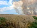
 Burning field in Donetsk Oblast, 2024-07-03 (01).webp 1,280 × 720; 130 KB
-
 Burning field in Donetsk Oblast, 2024-07-03 (02).webp 1,280 × 720; 40 KB
-
 Burning field in Donetsk Oblast, 2024-07-03 (03).webp 1,280 × 720; 129 KB
-
 Burning field near Andriivka, 2022-07-05 (01).jpg 1,280 × 960; 158 KB
-
 Burning field near Andriivka, 2022-07-05 (02).jpg 1,280 × 960; 202 KB
-
 Burning field near Andriivka, 2022-07-05 (03).jpg 1,280 × 960; 199 KB
-
 Burning field near Karasivka, 2024-07-01 (01).webp 1,280 × 960; 194 KB
-
 Burning field near Karasivka, 2024-07-01 (02).webp 1,280 × 960; 219 KB
-
 Burning field near Karasivka, 2024-07-01 (03).webp 1,280 × 960; 255 KB
-
 Burning field near Karasivka, 2024-07-01 (04).webp 1,280 × 960; 454 KB
-
 Burning field near Karasivka, 2024-07-01 (11).jpg 1,280 × 960; 210 KB
-
 Burning field near Monastyrske, 2024-06-07 (01).webp 940 × 762; 71 KB
-
 Burning field near Monastyrske, 2024-06-07 (02).webp 907 × 788; 76 KB
-
 Burning field near Suharivske, 2024-07-09 (01).jpg 738 × 492; 143 KB
-
 Burning field near Suharivske, 2024-07-09 (02).jpg 1,280 × 852; 561 KB
-
 Burnt wheat field in Illinivka, 2023-07-17 (1).jpg 1,280 × 960; 473 KB
-
 Burnt wheat field in Odesa region, 2023-07-17 (1).jpg 2,048 × 1,534; 421 KB
-
 Burnt wheat field in Odesa region, 2023-07-17 (2).jpg 1,024 × 767; 204 KB
-
 Cornflower , Western Ukraine.jpg 3,024 × 4,032; 3.76 MB
-
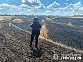
 Field in Bereznehuvate after Russian shelling, 2022-07-10.jpg 1,000 × 751; 411 KB
-
 Jan Stanisławski - Krajobraz letni (Pole ze snopkami zboża).jpg 2,500 × 1,768; 785 KB
-
 Kampo apud vilaĝo Rajgorodko (Novajdara distrikto).jpg 4,000 × 1,800; 1.97 MB
-
 Kampo en Zaporoĵa provinco.jpg 4,000 × 1,800; 2 MB
-
 Kampo rande de Vuhlehirsko.jpg 4,000 × 1,800; 1.6 MB
-
 Pole nad Ranjevoy kosoy.jpg 2,592 × 1,944; 2.33 MB
-
 Spasiv Rivne Oblast Ukraine 4.jpg 3,072 × 2,304; 5.71 MB
-
 Sunsubiro super la kampo en Zaporoĵa provinco.jpg 4,000 × 1,800; 1.89 MB
-
 Tyligul Lubopil.jpg 2,304 × 3,072; 3.43 MB
-
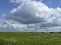
 Typical agricultural landscape of Kherson Oblast.jpg 800 × 532; 375 KB
-
 Verhuny, Cherkas'ka oblast, Ukraine, 19641 - panoramio.jpg 5,152 × 3,864; 4.5 MB
-
 Vidnyky view.JPG 2,848 × 4,288; 6.81 MB
-
 Wheat fields in Ukraine-5961.jpg 4,650 × 3,126; 13.17 MB
-
 Wheat fields in Ukraine-5962.jpg 5,184 × 3,456; 15.02 MB
-
 Wheat fields in Ukraine-5963.jpg 3,456 × 5,184; 11.72 MB
-
 Wheat fields in Ukraine-5965.jpg 5,184 × 2,706; 10.96 MB
-
 Wheat fields in Ukraine-5966-98.jpg 6,584 × 2,586; 12.37 MB
-
 Александровский район, Донецкая область, Украина.jpg 5,184 × 3,456; 6.91 MB
-
 Буде хліб.... - panoramio.jpg 2,048 × 1,536; 494 KB
-
 Геодезичний пункт дуги Струве і пшеничне поле.jpg 3,399 × 2,235; 4.2 MB
-
 На фоне пшеничного поля.jpg 5,184 × 3,456; 4.63 MB
-
 Покровська церква (дер.), с.Новородчиці, вигляд з дороги.jpg 4,272 × 2,848; 5.41 MB
-
 Поле - panoramio (42).jpg 2,816 × 2,112; 2.92 MB
-
 Поле озимини..JPG 3,984 × 2,656; 2.48 MB
-
 Поле озимой пшеницы в Днепропетровской области.jpg 3,456 × 4,608; 3.38 MB
-
 Поле пшениці. Дніпропетровщина.jpg 2,272 × 1,704; 697 KB
-
 Пшеница по пути в Седово.jpg 2,596 × 1,948; 2.62 MB
-
 Пшеничне поле. Запорізьке Правобережжя.jpg 1,600 × 900; 747 KB
-
 Пшеничное поле - panoramio (1).jpg 4,252 × 1,417; 3.01 MB
-
 Янків Яр 3.jpg 4,030 × 2,891; 2.37 MB
.webp)
.webp)
.webp)
.jpg)
.jpg)
.jpg)
.webp)
.webp)
.webp)
.webp)
.jpg)
.webp)
.webp)
.jpg)
.jpg)
.jpg)
.jpg)
.jpg)


.jpg)
.jpg)


,_%D1%81.%D0%9D%D0%BE%D0%B2%D0%BE%D1%80%D0%BE%D0%B4%D1%87%D0%B8%D1%86%D1%96,_%D0%B2%D0%B8%D0%B3%D0%BB%D1%8F%D0%B4_%D0%B7_%D0%B4%D0%BE%D1%80%D0%BE%D0%B3%D0%B8.jpg)
.jpg)


.jpg)