Category:Weston in Gordano
Jump to navigation
Jump to search
English: Weston in Gordano is a village and civil parish in Somerset, England. It is situated in the middle of the Gordano valley on the north side, and in the Unitary Authority of North Somerset, on the road between Clevedon and Portishead. The parish has a population of 300.
village in Somerset, UK  | |||||
| Upload media | |||||
| Instance of | |||||
|---|---|---|---|---|---|
| Location | Weston-in-Gordano, North Somerset, Somerset, South West England, England | ||||
 | |||||
Subcategories
This category has the following 3 subcategories, out of 3 total.
B
- Weston Big Wood (21 F)
W
- Weston Moor, Somerset (2 F)
Media in category "Weston in Gordano"
The following 86 files are in this category, out of 86 total.
-
 Arched openings in ruin - geograph.org.uk - 4954311.jpg 640 × 480; 117 KB
-
 B3124 - geograph.org.uk - 117581.jpg 640 × 480; 63 KB
-
 B3124 in Weston-in-Gordano - geograph.org.uk - 5813402.jpg 1,024 × 775; 151 KB
-
 B3124 near Woodside Grange - geograph.org.uk - 5813383.jpg 1,024 × 801; 116 KB
-
 Black Rock Quarry, Portishead - geograph.org.uk - 1070784.jpg 640 × 480; 83 KB
-
 Black Rock specialist police training centre - geograph.org.uk - 6341099.jpg 1,024 × 759; 148 KB
-
 Brockley Cottage, Blackberry Lane, Weston in Gordano - geograph.org.uk - 5218476.jpg 5,184 × 2,920; 6.36 MB
-

-
 Charlcombe Bay - geograph.org.uk - 1757069.jpg 640 × 426; 96 KB
-
 Charlcombe Bay - geograph.org.uk - 1757448.jpg 640 × 426; 98 KB
-
 Communications mast on Down Road - geograph.org.uk - 6341062.jpg 1,024 × 762; 109 KB
-
 Cross, Weston in Gordano - geograph.org.uk - 4087067.jpg 531 × 800; 183 KB
-
 Dead Fridges - geograph.org.uk - 132594.jpg 640 × 426; 110 KB
-
 Drainage ditch on Weston Moor - geograph.org.uk - 1186744.jpg 640 × 480; 91 KB
-
 Entrance, Weston Lodge - geograph.org.uk - 2455533.jpg 640 × 480; 110 KB
-
 Fields above Charlcombe - geograph.org.uk - 6341057.jpg 1,024 × 782; 174 KB
-
 Footpath to Nightingale Valley - geograph.org.uk - 6341092.jpg 1,024 × 768; 365 KB
-

-
 Former Signal Station, Walton Bay. - panoramio.jpg 2,816 × 2,112; 3.09 MB
-
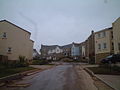
 Houses on Clevedon Road - geograph.org.uk - 6325954.jpg 1,024 × 761; 162 KB
-

-

-

-

-

-

-

-

-

-

-

-

-

-

-

-

-
 Mud in Walton Bay - geograph.org.uk - 1757459.jpg 640 × 426; 66 KB
-

-
 Ordnance Survey Cut Mark - geograph.org.uk - 4853586.jpg 480 × 640; 105 KB
-
 Recycling site at Blackrock Quarry - geograph.org.uk - 6341095.jpg 1,024 × 768; 174 KB
-
 Redcliff Bay Methodist Church - geograph.org.uk - 117674.jpg 640 × 480; 69 KB
-
 Redcliffe Bay Oil Depot - geograph.org.uk - 2455531.jpg 640 × 480; 82 KB
-
 Remains of Manor Farm above Nightingale Valley, Portishead - geograph.org.uk - 5218472.jpg 5,184 × 2,920; 5.63 MB
-
 Rhyne on Weston Moor - geograph.org.uk - 3610730.jpg 2,346 × 3,128; 2.39 MB
-
 Rhyne on Weston Moor - geograph.org.uk - 3610731.jpg 3,128 × 2,346; 2.76 MB
-
 Road to Charlcombe House - geograph.org.uk - 6341049.jpg 1,024 × 768; 132 KB
-
 Road, Weston Lodge - geograph.org.uk - 2454558.jpg 640 × 480; 102 KB
-
 Rock strata, Charlcombe Bay - geograph.org.uk - 1757444.jpg 640 × 426; 119 KB
-

-
 Rush hour at Valley Road junction - geograph.org.uk - 6325935.jpg 1,024 × 791; 197 KB
-
 Seaward side of Weston Down - geograph.org.uk - 2455528.jpg 640 × 480; 73 KB
-

-
 South across grid square - geograph.org.uk - 139836.jpg 640 × 480; 148 KB
-
-

-

-

-

-

-

-

-
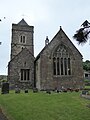
 St Peter ^ St Paul Church Weston in Gordano - geograph.org.uk - 6325948.jpg 1,024 × 768; 167 KB
-
 The White Hart, Weston in Gordano - geograph.org.uk - 4086494.jpg 800 × 531; 92 KB
-
 Tower - geograph.org.uk - 117588.jpg 640 × 480; 49 KB
-
 Under the M5 - geograph.org.uk - 697206.jpg 480 × 640; 133 KB
-
 Valley Road - geograph.org.uk - 6341071.jpg 1,024 × 789; 237 KB
-
 View across Weston Moor - geograph.org.uk - 4086485.jpg 800 × 531; 140 KB
-
 View from Seven Acre wood - geograph.org.uk - 1045891.jpg 640 × 480; 67 KB
-
 View over Walton Bay - geograph.org.uk - 6801976.jpg 4,032 × 3,024; 3.31 MB
-
 Weston Drove heading South across Weston Moor - geograph.org.uk - 3610733.jpg 2,346 × 3,128; 1.89 MB
-
 Weston in Gordano church - geograph.org.uk - 4086470.jpg 800 × 531; 122 KB
-
 Weston Moor - geograph.org.uk - 1891478.jpg 480 × 640; 90 KB
-
 Weston-in-Gordano SSSI.jpg 3,264 × 2,448; 1.47 MB
-
 Weston-in-Gordano SSSI2.jpg 3,264 × 2,448; 1.37 MB
-
 You have been warned - panoramio.jpg 2,112 × 2,816; 2.43 MB
-
 Black Rocks Quarry - geograph.org.uk - 139830.jpg 640 × 480; 140 KB
-
 Black Rocks Quarry - geograph.org.uk - 139847.jpg 640 × 480; 134 KB
-
 Channel view - geograph.org.uk - 139865.jpg 640 × 480; 117 KB
-
 Charlcombe Rise. - geograph.org.uk - 117669.jpg 640 × 480; 62 KB
-
 Civic Amenity-Recycling site - geograph.org.uk - 139859.jpg 640 × 480; 188 KB
-
 Climb up to Cadbury Camp - geograph.org.uk - 110503.jpg 640 × 480; 174 KB
-
 Common reed on Weston Moor - geograph.org.uk - 697194.jpg 640 × 480; 78 KB
-
 Fields By Walton in Gordano - geograph.org.uk - 132618.jpg 640 × 426; 142 KB
-
 Portishead Dump. - geograph.org.uk - 133810.jpg 640 × 426; 177 KB
-
 Preparing for The Flower Show - geograph.org.uk - 208987.jpg 640 × 480; 94 KB
-
 Rhyne on Weston Moor - geograph.org.uk - 132632.jpg 640 × 426; 134 KB


_-_geograph.org.uk_-_5445637.jpg)
_-_geograph.org.uk_-_5445639.jpg)
_-_geograph.org.uk_-_5445640.jpg)
_-_geograph.org.uk_-_5445641.jpg)
_-_geograph.org.uk_-_5445653.jpg)
_-_geograph.org.uk_-_5445646.jpg)
_-_geograph.org.uk_-_5445648.jpg)
_-_geograph.org.uk_-_5445649.jpg)
_-_geograph.org.uk_-_5445650.jpg)
_-_geograph.org.uk_-_5445654.jpg)
_-_geograph.org.uk_-_5445655.jpg)
_-_geograph.org.uk_-_5445665.jpg)
_-_geograph.org.uk_-_5445658.jpg)
_-_geograph.org.uk_-_5445659.jpg)
_-_geograph.org.uk_-_5445662.jpg)


_-_geograph.org.uk_-_5445629.jpg)
_-_geograph.org.uk_-_5445631.jpg)
_-_geograph.org.uk_-_5445632.jpg)
_-_geograph.org.uk_-_5445635.jpg)
_-_geograph.org.uk_-_5445636.jpg)


