Category:Wellington Region
Jump to navigation
Jump to search
Regions of New Zealand: Auckland · Bay of Plenty · Canterbury · Gisborne · Hawke's Bay · Manawatu-Whanganui · Marlborough · Nelson · Otago · Northland · Southland · Taranaki · Tasman · Waikato · Wellington · West Coast
Outlying islands, territories and dependencies: Antipodes Islands · Auckland Islands · Bounty Islands · Chatham Islands · Kermadec Islands · Snares Islands · Three Kings Islands · Tokelau – Territory with specific status: Ross Dependency
Associated countries: Cook Islands · Niue
Outlying islands, territories and dependencies: Antipodes Islands · Auckland Islands · Bounty Islands · Chatham Islands · Kermadec Islands · Snares Islands · Three Kings Islands · Tokelau – Territory with specific status: Ross Dependency
Associated countries: Cook Islands · Niue
region at the southern end of New Zealand's North Island | |||||
| Upload media | |||||
| Instance of |
| ||||
|---|---|---|---|---|---|
| Location | New Zealand | ||||
| Capital | |||||
| Inception |
| ||||
| Population |
| ||||
| Area |
| ||||
| official website | |||||
 | |||||
Subcategories
This category has the following 31 subcategories, out of 31 total.
Media in category "Wellington Region"
The following 170 files are in this category, out of 170 total.
-
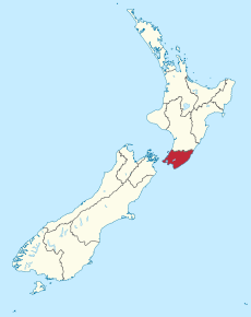
Position of Wellington Region.png 405 × 590; 7 KB
-
(King, Martha) Stratford's cottage, Hutt Road.jpg 1,080 × 868; 100 KB
-
1970-max.jpeg 1,000 × 557; 172 KB
-
20192020WGTN 01.jpg 2,073 × 3,684; 972 KB
-
20192020WGTN 02.jpg 2,189 × 3,893; 991 KB
-
20192020WGTN 03.jpg 3,648 × 2,052; 2.19 MB
-
20192020WGTN 04.jpg 4,032 × 2,268; 4.36 MB
-
20192020WGTN 05.jpg 2,268 × 4,032; 2.69 MB
-
20192020WGTN 06.jpg 2,268 × 4,032; 2.66 MB
-
20192020WGTN 07.jpg 4,032 × 3,024; 4.07 MB
-
20192020WGTN 08.jpg 4,032 × 2,268; 2.46 MB
-
20192020WGTN 09.jpg 4,032 × 2,268; 2.46 MB
-
20192020WGTN 10.jpg 4,032 × 2,268; 2.46 MB
-
20192020WGTN 11.jpg 4,032 × 2,268; 3.17 MB
-
20192020WGTN 12.jpg 4,032 × 2,268; 3.16 MB
-
20192020WGTN 13.jpg 2,268 × 4,032; 2.72 MB
-
20192020WGTN 14.jpg 2,268 × 2,268; 2.42 MB
-
20192020WGTN 15.jpg 2,268 × 4,032; 3 MB
-
20192020WGTN 16.jpg 3,831 × 2,170; 1.57 MB
-
20192020WGTN 17.jpg 4,032 × 3,024; 3.62 MB
-
20192020WGTN 18.jpg 4,032 × 3,024; 3.67 MB
-
20192020WGTN 19.jpg 3,024 × 4,032; 3.88 MB
-
20192020WGTN 20.jpg 3,024 × 4,032; 3.74 MB
-
20192020WGTN 21.jpg 3,024 × 4,032; 3.49 MB
-
20192020WGTN 22.jpg 3,024 × 4,032; 3.13 MB
-
20192020WGTN 23.jpg 3,024 × 4,032; 3.98 MB
-
20192020WGTN 24.jpg 2,268 × 4,032; 4.64 MB
-
20192020WGTN 25.jpg 2,268 × 4,032; 4.13 MB
-
20192020WGTN 26.jpg 2,268 × 4,032; 3.47 MB
-
20192020WGTN 27.jpg 3,221 × 1,698; 794 KB
-
A clearing in Nga Manu Nature Reserve.jpg 1,024 × 768; 334 KB
-
Atiwhakatu Stream.jpg 1,536 × 2,048; 1.67 MB
-
Australasian-Harrier-Makara-Beach.jpg 2,592 × 1,944; 1.4 MB
-
Brachyglottis pentacopa (1).jpg 2,048 × 1,536; 999 KB
-
Brachyglottis pentacopa.jpg 1,536 × 2,048; 1.52 MB
-
Breaker Bay, Wellington seen from Ataturk Memorial Park.jpg 8,160 × 6,120; 21.96 MB
-
Cattle trough made from an old bath (self filling) - panoramio.jpg 2,816 × 1,880; 4.21 MB
-
Coast of Wellington Region from Cook Strait.jpg 3,753 × 2,324; 4.24 MB
-
Crew-in-truck ResizedImageWzY2OCw0NDVd.jpg 668 × 445; 89 KB
-
Dipturus innominatus.jpg 852 × 1,074; 214 KB
-
Dolomedes dondalei 80223033.jpg 2,048 × 1,536; 2.02 MB
-
Example of a peak-specimen border collie (New Zealand).jpg 934 × 2,000; 337 KB
-
Farm Gates revisited - panoramio.jpg 2,816 × 1,880; 1.67 MB
-
Featherston Camp (1916) (23899055443).jpg 3,153 × 1,945; 2.69 MB
-
Feeding an egg to the pet eels at Battle Hill Reserve - panoramio.jpg 2,816 × 1,880; 1.88 MB
-
Fern bush in Nga Manu Nature Reserve.jpg 1,024 × 768; 395 KB
-
Ferry Near Welly Heads Towards Picton.jpg 2,200 × 1,200; 1.39 MB
-
Flat Point Beach.jpg 3,264 × 2,448; 1.7 MB
-
FMIB 34979 Catch of Trout, Wellington District.jpeg 888 × 682; 127 KB
-
Footbridge over Turere Stream.jpg 3,264 × 4,896; 7.06 MB
-
Fur seals at Wellington - panoramio (978).jpg 3,264 × 2,448; 3.33 MB
-
Gorse colonising disturbed areas 2.jpg 2,288 × 1,712; 1.9 MB
-
Haywards Electrical Substation.jpg 3,900 × 2,613; 1.53 MB
-
Hutt Valley from Belmont.jpg 2,592 × 1,944; 4.05 MB
-
Huttriver.jpg 1,280 × 960; 226 KB
-
IslandBayPICT4959.jpg 1,024 × 768; 201 KB
-
Judgeford.jpg 2,592 × 3,888; 3.03 MB
-
Kae Miller - Landscape (cropped 2).jpg 1,176 × 1,568; 199 KB
-
Kae Miller - Landscape (cropped).jpg 2,378 × 1,563; 388 KB
-
Kae Miller - Landscape.jpg 2,500 × 1,645; 434 KB
-
Kapiti Sunset (136301633).jpeg 2,048 × 1,152; 298 KB
-
Karaka Bays Waves.jpg 3,264 × 2,448; 2.1 MB
-
Kaukau Track (33526430105).jpg 11,287 × 5,701; 33.41 MB
-
Kupe's Sail-20070331.jpg 3,872 × 2,592; 2.38 MB
-
Kupe's Sail.jpg 804 × 603; 202 KB
-
LakeHorowhenua1800s.jpg 700 × 485; 80 KB
-
Lambs and girls (25027795806).jpg 900 × 694; 222 KB
-
Mackays Crossing 2007.jpg 2,848 × 2,134; 1.06 MB
-
Mackays Crossing 2010.jpg 3,888 × 2,592; 4.11 MB
-
Makara wind farm, Wellington, New Zealand, 26th. Nov. 2010 - Flickr - PhillipC (1).jpg 4,288 × 2,848; 2.64 MB
-
Makara wind farm, Wellington, New Zealand, 26th. Nov. 2010 - Flickr - PhillipC.jpg 3,825 × 2,384; 2.91 MB
-
Mana Island beach, looking towards Porirua, 14 Jan 2024.jpg 5,564 × 1,597; 5 MB
-
Mangatoetoe Stream.jpg 1,730 × 2,048; 1.3 MB
-
Marlborough Sounds From Space.jpg 3,032 × 2,008; 1.83 MB
-
Masterton Christmas Parade 2019.jpg 2,048 × 1,536; 811 KB
-
Miramar Peninsula aerial.jpg 2,000 × 1,500; 2.13 MB
-
Morning Sun (34818749755).jpg 7,435 × 7,435; 24.73 MB
-
New Zealand Alone (148455601).jpeg 2,048 × 1,365; 601 KB
-
New Zealand Cloud (148455921).jpeg 2,048 × 1,365; 298 KB
-
New Zeland Lake (148455299).jpeg 2,048 × 1,365; 864 KB
-
Nga Manu Nature Reserve overview.jpg 1,024 × 768; 321 KB
-
Old Rimu in Kaitoke Park.jpg 1,024 × 768; 314 KB
-
Opau Bay Panorama (51334202977).jpg 6,144 × 2,071; 14.02 MB
-
Oriential Bay (25965134564).jpg 14,703 × 5,574; 34.16 MB
-
Orongorata.jpg 320 × 427; 133 KB
-
Orongorongo Valley.jpg 3,264 × 4,896; 6.5 MB
-
Otaihanga Domain.jpg 2,848 × 2,134; 868 KB
-
Over grown foliage of Autumn - panoramio.jpg 1,880 × 2,816; 3.23 MB
-
Paekakariki.jpg 3,900 × 2,613; 1.6 MB
-
Paekākāriki yard.jpg 2,848 × 2,134; 1.2 MB
-
Palliser Coast.jpg 9,088 × 2,208; 2.75 MB
-
Paremata station building.jpg 3,072 × 2,304; 2.95 MB
-
Paremata station overview.jpg 3,072 × 2,304; 2.97 MB
-
Paremata station south end.jpg 3,072 × 2,304; 2.96 MB
-
Parsonsia heterophylla 11.JPG 2,976 × 3,968; 2.21 MB
-
Pencarrow Head and the Orongorongos from Island Bay, Wellington 24 April 2005 (10613085).jpg 2,592 × 1,944; 1.73 MB
-
Petone Esplanade Central - Wastewater Pumping Station.jpg 3,874 × 2,191; 1.11 MB
-
Petrus van der Velden - Storm at Wellington Heads - Google Art Project.jpg 5,108 × 3,233; 8.16 MB
-
Phormium tenax in Nga Manu Nature Reserve.jpg 1,024 × 768; 333 KB
-
Picton to Wellington Ferry (30931059754).jpg 5,125 × 2,934; 6.74 MB
-
Pictorial Illustrations of New Zealand.jpg 2,017 × 3,081; 2.43 MB
-
Plimmerton and Pauatahanui, New Zealand, 3rd. Dec. 2010 - Flickr - PhillipC.jpg 4,288 × 2,848; 3.58 MB
-
PointDorset.jpg 2,048 × 1,536; 1.71 MB
-
Pukerua Bay beach towards Kapiti Coast.jpg 1,024 × 768; 321 KB
-
Red Rocks Walkway - panoramio.jpg 4,928 × 3,264; 14.71 MB
-
Seal at Cape Palliser.jpg 3,264 × 2,448; 2.58 MB
-
Sevenoaks homestead, Whareama, New Zealand, ca 1860s.jpg 600 × 391; 160 KB
-
Silver Stream Railway - 2002-03-06 (cropped).jpg 801 × 574; 133 KB
-
Silver Stream Railway - 2002-03-06.jpg 1,041 × 737; 217 KB
-
Slider (15410241495).jpg 3,264 × 2,448; 1.92 MB
-
South coast, South Island in background - panoramio.jpg 3,072 × 2,304; 2.91 MB
-
Southern Coast of the North Island (26777936616).jpg 1,600 × 1,200; 417 KB
-
Southern end of Wainuiomata Valley.jpg 1,024 × 768; 316 KB
-
Southward Museum Otaihanga.jpg 2,848 × 2,134; 979 KB
-
Spectators at a tennis match in Miramar, 13 February 1932 (4939598018).jpg 3,270 × 2,555; 2.69 MB
-
Start of Waiotauru Track at Otaki Forks.jpg 1,024 × 768; 320 KB
-
Steam Inc passenger carriages.jpg 2,848 × 2,134; 924 KB
-
Steam Inc shunter.jpg 2,848 × 2,134; 993 KB
-
Stephen Models His Navajo Arrow Head (15418653305).jpg 2,333 × 1,748; 1.14 MB
-
Taputerangi Marine Reserve tide pools.jpg 4,640 × 3,480; 6.51 MB
-
Tararua bush at Otaki Forks.jpg 1,024 × 768; 319 KB
-
Te Awa Kairangi Hutt River Looking downstream.jpg 3,024 × 4,032; 4.11 MB
-
Terawhiti JAck.jpg 538 × 700; 79 KB
-
The Esplanade Houghton Bay - panoramio.jpg 3,072 × 1,728; 1.31 MB
-
The Pinnacles, Seatoun, Wellington.jpg 3,948 × 2,485; 1.19 MB
-
Titipounamu rifleman (adult female) perching.jpg 3,127 × 2,084; 5.84 MB
-
Titipounamu rifleman (adult female) with food in bill.jpg 3,127 × 2,084; 5.94 MB
-
Transmission Gully.jpg 1,024 × 768; 400 KB
-
Trees and shrubs.jpg 3,264 × 2,448; 1.1 MB
-
Turakirae head, Wellington New Zealand.JPG 1,024 × 768; 394 KB
-
Turere Stream flowing into Orongorongo River.jpg 3,264 × 4,896; 6.41 MB
-
Two Faces (148456623).jpeg 2,048 × 1,112; 1.46 MB
-
View down Hutt Valley from Mount Climie.jpg 1,024 × 768; 306 KB
-
View from Battle Hill, Pauatahanui.jpg 1,024 × 768; 279 KB
-
View from Raroa Reserve lookout down at coast.jpg 1,024 × 768; 333 KB
-
View from Raroa Reserve lookout towards Kapiti Coast.jpg 1,024 × 768; 327 KB
-
View towards Catchpool Valley entrance.jpg 1,024 × 768; 333 KB
-
View towards Kapiti from Tararua Forest Park.jpg 1,024 × 768; 305 KB
-
Waikanae River 2.jpg 1,024 × 768; 324 KB
-
WaikanaeRiverEnteringTasman.JPG 1,280 × 960; 517 KB
-
Walkway in Nikau Reserve, Paraparaumu.jpg 1,024 × 768; 320 KB
-
Walkway in Raroa Reserve.jpg 1,024 × 768; 343 KB
-
Water supply pipeline Silverstream Bridge.jpg 4,032 × 3,024; 2.63 MB
-
Wellington From Air - panoramio.jpg 1,200 × 1,600; 467 KB
-
Wellington Region location in New Zealand.svg 1,928 × 2,432; 258 KB
-
Wellington Region, New Zealand map.svg 940 × 744; 181 KB
-
WellingtonRegionPopulationDensity.png 970 × 640; 94 KB
-
WGTN WikiCon2023 02.png 691 × 538; 468 KB
-
WGTN WikiCon2023 03.png 540 × 540; 327 KB
-
Wind on the Coast (26555845110).jpg 1,600 × 1,200; 506 KB
-
惠灵顿 - panoramio (1).jpg 3,339 × 1,368; 1 MB
-
惠灵顿 - panoramio (10).jpg 5,365 × 1,477; 2.04 MB
-
惠灵顿 - panoramio (11).jpg 5,646 × 1,178; 1.57 MB
-
惠灵顿 - panoramio (12).jpg 5,143 × 1,229; 1.72 MB
-
惠灵顿 - panoramio (13).jpg 3,950 × 1,458; 1.84 MB
-
惠灵顿 - panoramio (2).jpg 3,616 × 1,528; 958 KB
-
惠灵顿 - panoramio (3).jpg 5,184 × 3,456; 7.61 MB
-
惠灵顿 - panoramio (4).jpg 5,184 × 3,456; 5.98 MB
-
惠灵顿 - panoramio (5).jpg 4,180 × 1,519; 1.19 MB
-
惠灵顿 - panoramio (6).jpg 5,184 × 3,456; 5.15 MB
-
惠灵顿 - panoramio (7).jpg 5,184 × 3,456; 7.06 MB
-
惠灵顿 - panoramio (8).jpg 5,184 × 3,456; 6.1 MB
-
惠灵顿 - panoramio (9).jpg 4,822 × 1,410; 2 MB
-
惠灵顿 - panoramio.jpg 3,456 × 5,184; 4.42 MB
-
惠灵顿新西兰 - panoramio (1).jpg 3,525 × 1,294; 1.65 MB
-
惠灵顿新西兰 - panoramio (2).jpg 4,011 × 1,549; 1.43 MB
-
惠灵顿新西兰 - panoramio (3).jpg 9,149 × 1,469; 5.11 MB
-
惠灵顿新西兰 - panoramio.jpg 5,444 × 1,489; 1.49 MB
-
惠灵顿机场 - panoramio.jpg 5,184 × 3,456; 5.22 MB


