Category:Visitors hill of the Transrapid Test Facility Emsland
Jump to navigation
Jump to search
| Object location | | View all coordinates using: OpenStreetMap |
|---|
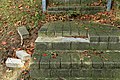
Deutsch: Stillgelegter Besucherhügel der Transrapid-Teststrecke an der Wippinger Straße in Kluse (Emsland). Ehemals Brückenkopf und Rampe einer Brücke über den Seitenkanal Gleesen-Papenburg.
Media in category "Visitors hill of the Transrapid Test Facility Emsland"
The following 12 files are in this category, out of 12 total.
-
 Kluse - Wippinger Straße + Transrapid + Transrapid-Besucherhügel 01 ies.jpg 5,616 × 3,744; 18.71 MB
-
 Kluse - Wippinger Straße - Transrapid-Besucherhügel + Hammoorgraben 01 ies.jpg 3,744 × 5,616; 23.1 MB
-
 Kluse - Wippinger Straße - Transrapid-Besucherhügel 01 ies.jpg 5,616 × 3,744; 21.55 MB
-
 Kluse - Wippinger Straße - Transrapid-Besucherhügel 02 ies.jpg 3,744 × 5,616; 24.2 MB
-
 Kluse - Wippinger Straße - Transrapid-Besucherhügel 03 ies.jpg 5,616 × 3,744; 28.41 MB
-
 Kluse - Wippinger Straße - Transrapid-Besucherhügel 04 ies.jpg 5,616 × 3,744; 26.74 MB
-
 Kluse - Wippinger Straße - Transrapid-Besucherhügel 05 ies.jpg 5,616 × 3,744; 25.37 MB
-
 Kluse - Wippinger Straße - Transrapid-Besucherhügel 06 ies.jpg 3,744 × 5,616; 22.75 MB
-
 Kluse - Wippinger Straße - Transrapid-Besucherhügel 07 ies.jpg 5,616 × 3,744; 26.3 MB
-
 Kluse - Wippinger Straße - Transrapid-Besucherhügel 08 ies.jpg 5,616 × 3,744; 30.25 MB
-
 Kluse - Wippinger Straße - Transrapid-Besucherhügel 09 ies.jpg 5,616 × 3,744; 27.88 MB
-
 Kluse - Wippinger Straße - Transrapid-Besucherhügel 10 ies.jpg 5,616 × 3,744; 31.28 MB