Category:Upper Benefield
Jump to navigation
Jump to search
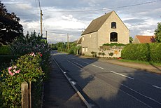
English: Upper Benefield is a linear village along the A427 road in the English county of Northamptonshire.
village in Northamptonshire, UK | |||||
| Upload media | |||||
| Instance of | |||||
|---|---|---|---|---|---|
| Location | Benefield, North Northamptonshire, Northamptonshire, East Midlands, England | ||||
 | |||||
Subcategories
This category has only the following subcategory.
Media in category "Upper Benefield"
The following 25 files are in this category, out of 25 total.
-
Four For Sale - geograph.org.uk - 187411.jpg 640 × 480; 85 KB
-
Upper Benefield - geograph.org.uk - 484575.jpg 640 × 428; 95 KB
-
Bridleway entrance to Holey Brookes wood - geograph.org.uk - 269173.jpg 640 × 480; 162 KB
-
Bridleway into Deenethorpe Airfield - geograph.org.uk - 270222.jpg 640 × 480; 59 KB
-
Bridleway to Langley Coppice - geograph.org.uk - 270235.jpg 640 × 480; 69 KB
-
Coterstock Lock River Nene - geograph.org.uk - 266701.jpg 640 × 480; 61 KB
-
Edge of tree belt - geograph.org.uk - 487351.jpg 640 × 480; 101 KB
-
Exciting welcome to Rockingham Forest - geograph.org.uk - 269231.jpg 640 × 480; 118 KB
-
Farmland near Upper Benefield - geograph.org.uk - 484535.jpg 640 × 428; 104 KB
-
Farmland near Upper Benefield - geograph.org.uk - 484544.jpg 640 × 428; 89 KB
-
Footpath Bridge near Upper Benefield - geograph.org.uk - 484626.jpg 640 × 428; 125 KB
-
Footpath Bridge near Upper Benefield - geograph.org.uk - 484634.jpg 640 × 428; 152 KB
-
Footpath scarecrow - geograph.org.uk - 269139.jpg 640 × 480; 103 KB
-
Forest Lodge - geograph.org.uk - 269376.jpg 640 × 480; 71 KB
-
Frere Hill Wood - geograph.org.uk - 269366.jpg 640 × 480; 82 KB
-
Home Farm Lodge - geograph.org.uk - 270238.jpg 640 × 480; 55 KB
-
Service road, Deenethorpe Airfield - geograph.org.uk - 270210.jpg 640 × 480; 71 KB
-
Track alongside Rough Close - geograph.org.uk - 269382.jpg 640 × 480; 69 KB
-
Track north-east toward Spa Farm - geograph.org.uk - 269128.jpg 640 × 480; 61 KB
-
Track to Harry's Park - geograph.org.uk - 375742.jpg 640 × 480; 71 KB
-
View east from Wymond Hill - geograph.org.uk - 269362.jpg 640 × 480; 68 KB


