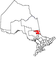
Category:Unorganized Timiskaming, West Part
Jump to navigation
Jump to search
unorganized area in Ontario, Canada | |||||
| Upload media | |||||
| Instance of | |||||
|---|---|---|---|---|---|
| Location | Timiskaming District, Ontario, Canada | ||||
| Population |
| ||||
| Area |
| ||||
 | |||||
Subcategories
This category has the following 8 subcategories, out of 8 total.
B
- Boston Creek, Ontario (1 F)
C
- Capitol Mine (1 F)
- Castle Mine (4 F)
D
- Devil's Rock (16 F)
G
- Gowganda Lake (4 F)
- Gowganda, Ontario (8 F)
M
Media in category "Unorganized Timiskaming, West Part"
The following 14 files are in this category, out of 14 total.
-
"Great Bear Lake views" (3778131266).jpg 2,048 × 1,650; 391 KB
-
Arctic Watershed - Highway 11, Ontario.jpg 897 × 1,000; 731 KB
-
Dane ON.JPG 1,022 × 611; 179 KB
-
Hill's Lake Hatchery brooding stock pen - panoramio.jpg 3,968 × 2,976; 4.99 MB
-
Hill's Lake Hatchery inside late rearing pen - panoramio.jpg 3,968 × 2,976; 4.48 MB
-
Hill's Lake Hatchery late rearing pen - panoramio.jpg 3,968 × 2,976; 5.49 MB
-
Kenabeek ON.JPG 2,592 × 1,726; 1.23 MB
-
Kenogami Lake ON.JPG 1,156 × 757; 718 KB
-
King Kirkland ON.jpg 1,023 × 738; 152 KB
-
ONTARIO SESSIONAL PAPERS, 1915, No.3-4 (1915) (14762703284).jpg 3,072 × 1,982; 910 KB
-
Sesekinika ON.JPG 1,164 × 815; 178 KB
-
Tarzwell ON.JPG 1,405 × 815; 293 KB
-
Tomstown ON.JPG 1,227 × 844; 253 KB
-
Unorg West Timiskaming.png 378 × 379; 6 KB


