Category:United Kingdom photographs taken on 2009-12-30
Jump to navigation
Jump to search
| ← | Wednesday 30 December 2009 | → | ||
| ← | December 2009 | → | ||

United Kingdom photographs taken on 30 December 2009.
Image files should be categorized here automatically using {{taken on}} template. Direct categorisation is also possible, if automatic is impossible.
Subcategories
This category has the following 2 subcategories, out of 2 total.
L
Media in category "United Kingdom photographs taken on 2009-12-30"
The following 200 files are in this category, out of 504 total.
(previous page) (next page)-
-
-
 84 bus on the bypass roundabout - geograph.org.uk - 1639810.jpg 640 × 480; 45 KB
-
 A bleak day on Arundel riverfront - geograph.org.uk - 1657187.jpg 480 × 640; 52 KB
-

-

-
 A dull December day in River Road - geograph.org.uk - 1653533.jpg 480 × 640; 56 KB
-
 A dull December day on the Arun - geograph.org.uk - 1653469.jpg 640 × 480; 34 KB
-
 A good address - geograph.org.uk - 1657202.jpg 480 × 640; 56 KB
-
 A grander Norfolk Arms - geograph.org.uk - 1659298.jpg 480 × 640; 73 KB
-

-

-

-

-

-
-

-

-

-

-

-

-

-

-

-

-

-
 A wet and windy Maltravers Street - geograph.org.uk - 1660641.jpg 640 × 480; 72 KB
-
 A wet day approaching "Good as new" - geograph.org.uk - 1657099.jpg 480 × 640; 76 KB
-
 A wet day by the war memorial - geograph.org.uk - 1659265.jpg 480 × 640; 65 KB
-
 Abbey Lighthouse, Lune estuary - geograph.org.uk - 1639154.jpg 480 × 640; 90 KB
-
 Abbey Road, Kirkstall - geograph.org.uk - 1766197.jpg 800 × 600; 131 KB
-

-
 All Saints Church Driffield 1.jpg 1,704 × 2,272; 816 KB
-
 All Saints Church Driffield 2.jpg 1,704 × 2,272; 1.17 MB
-
 All Saints North Street - geograph.org.uk - 1691691.jpg 640 × 427; 104 KB
-
-

-
 And still they came - geograph.org.uk - 1659230.jpg 480 × 640; 60 KB
-
 Antiquities in Arundel town centre - geograph.org.uk - 1659374.jpg 480 × 640; 72 KB
-
 Apartments on the Arun - geograph.org.uk - 1657199.jpg 640 × 437; 53 KB
-
 Approaching a bend in Brewery Hill - geograph.org.uk - 1653433.jpg 480 × 640; 57 KB
-
-

-
 Approaching Cardrona Village - geograph.org.uk - 1639153.jpg 640 × 424; 65 KB
-

-

-

-

-
 Arch within Arundel Cathedral - geograph.org.uk - 1640584.jpg 480 × 640; 63 KB
-
 Art gallery in Tarrant Street - geograph.org.uk - 1659463.jpg 502 × 640; 64 KB
-
 Artwork in River Road - geograph.org.uk - 1653454.jpg 480 × 640; 67 KB
-

-

-
 Arundel Post Office - geograph.org.uk - 1657188.jpg 640 × 467; 53 KB
-
 Ashdown in River Road - geograph.org.uk - 1653444.jpg 640 × 480; 84 KB
-
 B1211 near Brocklesby Station - geograph.org.uk - 1651510.jpg 640 × 480; 331 KB
-

-
 Balconies in River Road - geograph.org.uk - 1653473.jpg 640 × 480; 77 KB
-
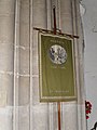 Banner within St Nicholas, Arundel - geograph.org.uk - 1640790.jpg 480 × 640; 61 KB
-

-
 Belinda's 16th Century Restaurant - geograph.org.uk - 1659371.jpg 480 × 640; 73 KB
-
 Bench without a view - geograph.org.uk - 1639968.jpg 640 × 480; 161 KB
-
 Bend in the River Foyers - geograph.org.uk - 1639093.jpg 640 × 480; 59 KB
-

-
 Bicknoller Shop - geograph.org.uk - 1655571.jpg 640 × 430; 124 KB
-
 Bicknoller Village sign - geograph.org.uk - 1706855.jpg 640 × 480; 74 KB
-
 Bishops Lydeard - FO 3108 Aries in maroon livery.JPG 1,366 × 1,024; 332 KB
-

-
 Bridge 108, Lancaster Canal - geograph.org.uk - 1651773.jpg 640 × 480; 67 KB
-
 Bridge 109, Lancaster Canal - geograph.org.uk - 1651761.jpg 640 × 480; 98 KB
-
 Bridge 113, Lancaster Canal - geograph.org.uk - 1640885.jpg 640 × 480; 76 KB
-
 Bridge 114, Lancaster Canal - geograph.org.uk - 1640882.jpg 640 × 480; 84 KB
-
 Bridge 115, Lancaster Canal - geograph.org.uk - 1640880.jpg 640 × 480; 84 KB
-
 Bridge 116, Lancaster Canal - geograph.org.uk - 1640872.jpg 640 × 480; 75 KB
-
 Bridge 117, Lancaster Canal - geograph.org.uk - 1640867.jpg 640 × 480; 80 KB
-
 Broadway from the east - geograph.org.uk - 1639471.jpg 640 × 479; 89 KB
-
 Brocklesby Park - The Canal - geograph.org.uk - 1638924.jpg 640 × 404; 335 KB
-
 Brocklesby Station - geograph.org.uk - 1640429.jpg 640 × 481; 345 KB
-

-

-
 Butchers in the High Street - geograph.org.uk - 1657124.jpg 480 × 640; 64 KB
-
 Butlers in Tarrant Street - geograph.org.uk - 1659417.jpg 480 × 640; 63 KB
-
 Cademuir Hill - geograph.org.uk - 1744044.jpg 480 × 640; 43 KB
-

-
 Car park in River Road - geograph.org.uk - 1653542.jpg 640 × 480; 60 KB
-
 Cardrona Village - geograph.org.uk - 1639136.jpg 640 × 424; 93 KB
-
 Carew Arms, Crowcombe - geograph.org.uk - 1656522.jpg 640 × 430; 111 KB
-
 Cars passing down Mill Lane - geograph.org.uk - 1657233.jpg 480 × 640; 62 KB
-
 Castle Chocolates in Tarrant Street - geograph.org.uk - 1659375.jpg 480 × 640; 61 KB
-
 Castle Mews in Tarrant Street - geograph.org.uk - 1659477.jpg 480 × 640; 52 KB
-
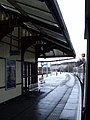 Cathcart railway station - geograph.org.uk - 1641781.jpg 480 × 640; 65 KB
-

-
 Chilcombe Lane - geograph.org.uk - 1657275.jpg 640 × 430; 158 KB
-
 Choir stalls at St Nicholas, Arundel - geograph.org.uk - 1640781.jpg 640 × 473; 63 KB
-
 Christmas at St Nicholas, Arundel - geograph.org.uk - 1640899.jpg 640 × 480; 51 KB
-
 Church House, Crowcombe - geograph.org.uk - 1656516.jpg 640 × 519; 84 KB
-

-
 Class 117 TCL 59515.jpg 1,024 × 512; 122 KB
-
 Close encounter of the wall kind - geograph.org.uk - 1638684.jpg 640 × 480; 102 KB
-

-
 Cockerham Sands and the Lune estuary - geograph.org.uk - 1639312.jpg 640 × 480; 48 KB
-
 Coire Leitir-achain - geograph.org.uk - 1639658.jpg 480 × 640; 53 KB
-

-

-
 Cottages in River Road - geograph.org.uk - 1653538.jpg 640 × 458; 55 KB
-
 Cottages in Tarrant Street - geograph.org.uk - 1660546.jpg 640 × 480; 88 KB
-
 Country Kitchen in Arundel Street - geograph.org.uk - 1659467.jpg 480 × 640; 57 KB
-
 Crib scene within Arundel Cathedral - geograph.org.uk - 1640678.jpg 640 × 480; 81 KB
-
 Crowcombe Combe Gate - geograph.org.uk - 1656335.jpg 640 × 430; 135 KB
-
 Crowcombe Court - geograph.org.uk - 1706683.jpg 640 × 480; 113 KB
-
 Crowcombe Cross - geograph.org.uk - 1656521.jpg 430 × 640; 79 KB
-
 Crowcombe Hill - geograph.org.uk - 1656412.jpg 640 × 430; 122 KB
-
 Crowcombe Hill - geograph.org.uk - 1656440.jpg 640 × 430; 138 KB
-

-
 Crown Yard Car Park - geograph.org.uk - 1657138.jpg 640 × 480; 69 KB
-
 Crucifix within Arundel Cathedral - geograph.org.uk - 1640599.jpg 480 × 640; 67 KB
-
 Cubittandwest in the High Street - geograph.org.uk - 1659303.jpg 480 × 640; 63 KB
-

-

-
 Dais within Arundel Cathedral - geograph.org.uk - 1640673.jpg 480 × 640; 62 KB
-
 Damaged Landing Lights - geograph.org.uk - 1639145.jpg 640 × 427; 63 KB
-
 Dashwood Coach House - geograph.org.uk - 1655493.jpg 640 × 430; 146 KB
-
 Dead tree, Barnett Demesne, Belfast - geograph.org.uk - 1639338.jpg 640 × 413; 112 KB
-

-
 Debris from the beach - geograph.org.uk - 1639938.jpg 480 × 640; 141 KB
-

-

-
 Distant barn off The Causeway - geograph.org.uk - 1639808.jpg 640 × 480; 48 KB
-

-

-

-
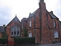 Driffield CofE VC Primary School 1.jpg 2,272 × 1,704; 880 KB
-
 Driffield CofE VC Primary School 2.jpg 2,272 × 1,704; 783 KB
-
 Driffield Methodist Church.jpg 2,272 × 1,704; 738 KB
-
 Drinking fountain, Meadfoot Beach - geograph.org.uk - 1639931.jpg 480 × 640; 189 KB
-
 Education office 091230-F-HZ730-020.jpg 2,848 × 4,288; 5.01 MB
-
 Eklectica in Tarrant Street - geograph.org.uk - 1659402.jpg 480 × 640; 57 KB
-
 Entrance to Kirkstall Forge - geograph.org.uk - 1766184.jpg 800 × 600; 105 KB
-
 Entrance to St Nicholas, Arundel - geograph.org.uk - 1640744.jpg 640 × 480; 98 KB
-
 Entrance to the Osbourne Hotel, Torquay - geograph.org.uk - 1639957.jpg 640 × 480; 105 KB
-
 Fallen tree, Barnett Demesne, Belfast - geograph.org.uk - 1639441.jpg 640 × 387; 134 KB
-
 Farmhouse, Paradise Farm - geograph.org.uk - 1658092.jpg 640 × 401; 49 KB
-

-

-
 Field by Hill Lane - geograph.org.uk - 1655635.jpg 640 × 430; 122 KB
-
 Field to the north of The Causeway - geograph.org.uk - 1639805.jpg 640 × 480; 43 KB
-
-

-

-
 Footpath in the woods - geograph.org.uk - 1639972.jpg 640 × 480; 207 KB
-
 Footpath near Cockersand Abbey - geograph.org.uk - 1640069.jpg 480 × 640; 97 KB
-
 From the Towpath - geograph.org.uk - 1640876.jpg 640 × 480; 59 KB
-

-
 Gate, Lagan towpath, Belfast - geograph.org.uk - 1639379.jpg 593 × 369; 109 KB
-
 Glen Croe - geograph.org.uk - 1639678.jpg 640 × 480; 76 KB
-

-
 Grazing land near Thurnham - geograph.org.uk - 1639123.jpg 640 × 480; 68 KB
-
 Great Marlborough Street - geograph.org.uk - 1639575.jpg 640 × 428; 54 KB
-
 Green Lane in winter - geograph.org.uk - 1638943.jpg 640 × 640; 337 KB
-
 Greengrocers in Tarrant Street - geograph.org.uk - 1659405.jpg 480 × 640; 69 KB
-
 Grounds in Arundel High Street - geograph.org.uk - 1659285.jpg 480 × 640; 59 KB
-
 Hairdressers in Arundel town centre - geograph.org.uk - 1657113.jpg 640 × 480; 98 KB
-

-
 Halsway Lane - geograph.org.uk - 1656887.jpg 640 × 430; 136 KB
-
 Halsway Lane - geograph.org.uk - 1657034.jpg 640 × 430; 133 KB
-
 Halsway Manor - geograph.org.uk - 1656999.jpg 640 × 430; 125 KB
-
 Hesketh Crescent, Torquay - geograph.org.uk - 1639952.jpg 640 × 480; 100 KB
-
 Hesketh Crescent, Torquay - geograph.org.uk - 1639960.jpg 640 × 480; 101 KB
-
 High Pavement - geograph.org.uk - 1639510.jpg 640 × 480; 91 KB
-

-
 Iced Loch Restil - geograph.org.uk - 1639634.jpg 640 × 480; 100 KB
-
 Il Lusso in Tarrant Street - geograph.org.uk - 1659368.jpg 480 × 640; 60 KB
-
 Ilsham Marine Drive, Torquay - geograph.org.uk - 1639910.jpg 640 × 480; 107 KB
-
 In Cardrona Village - geograph.org.uk - 1639160.jpg 640 × 424; 76 KB
-
 India Gate in Mill Lane - geograph.org.uk - 1659248.jpg 480 × 640; 85 KB
-

-

-

-

-
 Kestevan Recreation Ground, Crowcombe - geograph.org.uk - 1656595.jpg 640 × 430; 118 KB
-
 Kirkstall Forge milepost - geograph.org.uk - 1766219.jpg 450 × 600; 109 KB
-
 Lampposts in The Causeway - geograph.org.uk - 1639799.jpg 480 × 640; 41 KB
-
 Lancaster Canal - geograph.org.uk - 1639848.jpg 640 × 480; 78 KB
-
 Lancaster Canal - geograph.org.uk - 1640870.jpg 640 × 480; 75 KB
-
 Lancaster Canal - geograph.org.uk - 1640878.jpg 640 × 480; 74 KB
-
 Lancaster Canal - geograph.org.uk - 1640881.jpg 640 × 480; 67 KB
-
 Large ornate house, Crowcombe - geograph.org.uk - 1656563.jpg 640 × 430; 142 KB
-
-

-
 Late afternoon, late December - geograph.org.uk - 1638970.jpg 640 × 481; 208 KB
-
 Leafless trees, Barnett Demesne, Belfast - geograph.org.uk - 1639234.jpg 591 × 343; 100 KB
-
 Lesley Cannon in Tarrant Street - geograph.org.uk - 1659384.jpg 480 × 640; 72 KB
-
 Lincombe Drive, Torquay - geograph.org.uk - 1639978.jpg 640 × 480; 138 KB
-
 Lincombe Drive, Torquay - geograph.org.uk - 1639983.jpg 640 × 480; 159 KB
-
 Line of trees south of Halsway Lane - geograph.org.uk - 1657083.jpg 640 × 430; 109 KB
-
 Little Mill Corn Mill - geograph.org.uk - 1639328.jpg 640 × 480; 104 KB
-

-
 Little Mill millpond - geograph.org.uk - 1639335.jpg 640 × 480; 99 KB
-
 Lodge, Halsway Manor - geograph.org.uk - 1657021.jpg 640 × 430; 113 KB


_-_geograph.org.uk_-_1640745.jpg)
_-_geograph.org.uk_-_1640770.jpg)
_-_geograph.org.uk_-_1640772.jpg)
_-_geograph.org.uk_-_1640775.jpg)
_-_geograph.org.uk_-_1640750.jpg)
_-_geograph.org.uk_-_1640752.jpg)
_-_geograph.org.uk_-_1640758.jpg)
_-_geograph.org.uk_-_1640757.jpg)
_-_geograph.org.uk_-_1640760.jpg)
_-_geograph.org.uk_-_1640761.jpg)
_-_geograph.org.uk_-_1640771.jpg)
_-_geograph.org.uk_-_1640766.jpg)


