Category:United Kingdom photographs taken on 2009-02-20
Jump to navigation
Jump to search
| ← | Friday 20 February 2009 | → | ||
| ← | February 2009 | → | ||

United Kingdom photographs taken on 20 February 2009.
Image files should be categorized here automatically using {{taken on}} template. Direct categorisation is also possible, if automatic is impossible.
Subcategories
This category has the following 2 subcategories, out of 2 total.
Media in category "United Kingdom photographs taken on 2009-02-20"
The following 200 files are in this category, out of 1,230 total.
(previous page) (next page)-
 "Hill 60" Quarry near Hollow Tor - geograph.org.uk - 1174624.jpg 640 × 494; 122 KB
-
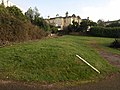
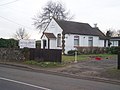
 "Homelands" Mobile Home Park - geograph.org.uk - 1173488.jpg 640 × 480; 352 KB
-
-

-
 "Stone Cottage" at Coombswell - geograph.org.uk - 1173908.jpg 640 × 360; 77 KB
-
 (1932) Spring Usher (Agriopis leucophaearia) (3294930300).jpg 2,848 × 2,136; 1.49 MB
-
 A crowd - geograph.org.uk - 1171547.jpg 640 × 480; 109 KB
-
 A glorious February morning - geograph.org.uk - 1170499.jpg 640 × 377; 26 KB
-
 A view across the Zig-Zag path - geograph.org.uk - 1173742.jpg 640 × 480; 141 KB
-
 A view down the Zig-Zag path in the mist - geograph.org.uk - 1173690.jpg 640 × 480; 107 KB
-
 A view east along part of the Pyg Track - geograph.org.uk - 1190069.jpg 640 × 480; 159 KB
-
 A view up the Zig-Zag path - geograph.org.uk - 1173731.jpg 640 × 480; 98 KB
-
 A' Chuil Bothy - geograph.org.uk - 1240290.jpg 640 × 480; 121 KB
-

-
 Abbey House, Whitby - geograph.org.uk - 1175286.jpg 640 × 480; 70 KB
-
 Aberfforest bay - geograph.org.uk - 1171812.jpg 640 × 480; 68 KB
-
 Aberfforest bay from above - geograph.org.uk - 1171961.jpg 640 × 480; 110 KB
-
 Aberfforest waterfall from above - geograph.org.uk - 1171356.jpg 480 × 640; 137 KB
-
 Abingdon Street - Toller Lane - geograph.org.uk - 1173247.jpg 640 × 451; 188 KB
-
 Accommodation, Slevins, Omagh - geograph.org.uk - 1170727.jpg 640 × 480; 53 KB
-
 Across to Ludlow - geograph.org.uk - 1174916.jpg 640 × 426; 59 KB
-

-
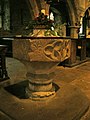 All Angels Church, Hubberholme, Font - geograph.org.uk - 1171600.jpg 480 × 640; 90 KB
-

-
-

-
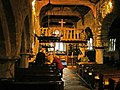
 All Angels Church, Hubberholme. - geograph.org.uk - 1171577.jpg 640 × 480; 70 KB
-
 All Saints, Sudbury - geograph.org.uk - 1170613.jpg 640 × 480; 78 KB
-

-
 Allotments - Scotchman Road - geograph.org.uk - 1172550.jpg 640 × 480; 265 KB
-
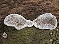
 An a-maze-ing fungus^ - geograph.org.uk - 1170749.jpg 640 × 450; 120 KB
-
 An entrance to Hafod Eryri on Yr Wyddfa - geograph.org.uk - 1175092.jpg 640 × 480; 197 KB
-
 Another fishing spot - geograph.org.uk - 1173134.jpg 400 × 600; 98 KB
-
 Approaching Higher Greenway - geograph.org.uk - 1176817.jpg 469 × 640; 99 KB
-
 Approaching Invermoriston - geograph.org.uk - 1171377.jpg 640 × 480; 50 KB
-
 Area at rear of Torquay Lawn Tennis Club - geograph.org.uk - 1176647.jpg 640 × 480; 101 KB
-
 Arncliffe - geograph.org.uk - 1171608.jpg 640 × 479; 75 KB
-
 Asda at Sports City - geograph.org.uk - 1171236.jpg 640 × 395; 93 KB
-
 Ash Chapel - geograph.org.uk - 1178609.jpg 640 × 481; 73 KB
-
 Ashcroft Court - geograph.org.uk - 1756398.jpg 640 × 479; 65 KB
-

-
 B of the Bang Sign - geograph.org.uk - 1171199.jpg 640 × 530; 136 KB
-
 Back Girlington Road - Thorn Street - geograph.org.uk - 1171087.jpg 480 × 640; 209 KB
-
 Back Kensington Street - Thorn Street - geograph.org.uk - 1171106.jpg 480 × 640; 211 KB
-
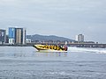 Bae Caerdydd - geograph.org.uk - 1434012.jpg 640 × 480; 48 KB
-
 Banc y Llyn from the north west - geograph.org.uk - 1170896.jpg 1,088 × 816; 344 KB
-
 BandQ store, Bury St Edmunds - geograph.org.uk - 1170643.jpg 640 × 427; 76 KB
-
 Bang in the Centre - geograph.org.uk - 1171226.jpg 640 × 480; 106 KB
-
 Bare tree and woolly sheep - geograph.org.uk - 1189804.jpg 640 × 426; 79 KB
-
 Baslow Grove - Smith Lane - geograph.org.uk - 1172305.jpg 640 × 480; 249 KB
-
 Bat boxes, Studhampton - geograph.org.uk - 1172478.jpg 640 × 480; 148 KB
-
 Battersea Dogs Home - geograph.org.uk - 1178445.jpg 640 × 481; 76 KB
-
 Bavaria Place - Church Street - geograph.org.uk - 1173245.jpg 640 × 480; 255 KB
-
 Bayswater Road - geograph.org.uk - 1172635.jpg 640 × 480; 65 KB
-
 Bayswater Road - geograph.org.uk - 1172677.jpg 640 × 480; 58 KB
-
 Beach Marker - geograph.org.uk - 1183739.jpg 427 × 640; 135 KB
-
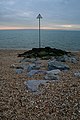
 Beach with Marker - geograph.org.uk - 1183741.jpg 640 × 427; 82 KB
-
 Beacon - geograph.org.uk - 1179832.jpg 640 × 480; 58 KB
-
 Beckley Mast - geograph.org.uk - 1172726.jpg 640 × 480; 80 KB
-
 Beeches Lane, Carrington - geograph.org.uk - 1196866.jpg 640 × 480; 205 KB
-
 Belgrave Road, Torquay - geograph.org.uk - 1176613.jpg 480 × 640; 68 KB
-
 Belle Vue Mills, Broughton Road - geograph.org.uk - 1171326.jpg 480 × 640; 85 KB
-
 Belle Vue Mills, Broughton Road - geograph.org.uk - 1171334.jpg 640 × 480; 79 KB
-

-
 Bench-on-the-Front - geograph.org.uk - 1183726.jpg 640 × 427; 66 KB
-
 Benches on the Front - geograph.org.uk - 1183737.jpg 640 × 427; 109 KB
-
 Bend in Wisley Lane - geograph.org.uk - 1170917.jpg 640 × 480; 86 KB
-
 Bends ahead - geograph.org.uk - 1171703.jpg 640 × 480; 121 KB
-
 Billet Wood - geograph.org.uk - 1178456.jpg 640 × 481; 124 KB
-
 Birch Terrace, Netherton - geograph.org.uk - 1173409.jpg 640 × 460; 77 KB
-

-
 Black Footpath - geograph.org.uk - 1171129.jpg 640 × 480; 133 KB
-

-
 Blue House - geograph.org.uk - 1756375.jpg 479 × 640; 62 KB
-
 BMX-Skateboard Circuit, Whitley Bay - geograph.org.uk - 1179776.jpg 640 × 480; 67 KB
-
 Bog north of Banc y Llyn - geograph.org.uk - 1170919.jpg 1,088 × 816; 488 KB
-

-
 Boggy ground on Mynydd Pencarreg - geograph.org.uk - 1176896.jpg 640 × 480; 69 KB
-
-

-
 Boundary marker in the corner - geograph.org.uk - 1175752.jpg 640 × 426; 120 KB
-
 Bowderdale from Yewbarrow - geograph.org.uk - 1179193.jpg 640 × 480; 73 KB
-
 All Saints Bradfield Combust - geograph.org.uk - 1170902.jpg 640 × 480; 129 KB
-
 Bradford Girls Grammar School.jpg 640 × 480; 232 KB
-
 Brandwood Park Road. Crossroads - geograph.org.uk - 1171629.jpg 640 × 480; 67 KB
-
 Brent Geese, on the Exe Estuary - geograph.org.uk - 1170722.jpg 640 × 480; 56 KB
-
 Brick and stone bridge - geograph.org.uk - 1171816.jpg 480 × 640; 144 KB
-

-
 Bridge Farm - geograph.org.uk - 1171836.jpg 640 × 480; 80 KB
-
-

-
 Bridge over Darnbrook Beck - geograph.org.uk - 1171609.jpg 640 × 462; 93 KB
-
 Bridge over the A40 - geograph.org.uk - 1173237.jpg 640 × 416; 87 KB
-
 Bridge over the River Trothy - geograph.org.uk - 1171813.jpg 640 × 480; 167 KB
-
 Bridge Railing across Allt Saigh - geograph.org.uk - 1171265.jpg 640 × 480; 133 KB
-
 Bridgwater Road - Farfield Terrace - geograph.org.uk - 1170795.jpg 640 × 461; 204 KB
-
-
 Bridleway by pumping house - geograph.org.uk - 1172798.jpg 640 × 480; 83 KB
-
 Bridleway meets Wises Lane - geograph.org.uk - 1178347.jpg 640 × 481; 104 KB
-
 Bridleway near Garth Farm - geograph.org.uk - 1171799.jpg 640 × 480; 134 KB
-
 Bridleway on Hatham Green Lane - geograph.org.uk - 1178335.jpg 640 × 481; 91 KB
-
 Bridleway to Cilcain - geograph.org.uk - 1171794.jpg 640 × 480; 124 KB
-
 Bridleway towards Ware - geograph.org.uk - 1176473.jpg 640 × 480; 132 KB
-
 Bridleway, Stubhampton Bottom - geograph.org.uk - 1172498.jpg 640 × 480; 152 KB
-
 Britannia Care Home - Thorn Street - geograph.org.uk - 1171121.jpg 640 × 499; 216 KB
-
 Bryniau Pica - geograph.org.uk - 1170871.jpg 1,024 × 768; 499 KB
-
-
 Buckden Village Stores - geograph.org.uk - 1171575.jpg 640 × 480; 59 KB
-
 Buildings by The Common - geograph.org.uk - 1756547.jpg 640 × 466; 69 KB
-
 Burrator Reservoir Boundary Stone - geograph.org.uk - 1174420.jpg 640 × 480; 121 KB
-

-
 Bush Cleugh - geograph.org.uk - 1171016.jpg 640 × 480; 97 KB
-
 Bush Cleugh from Salter's Road - geograph.org.uk - 1170908.jpg 640 × 360; 75 KB
-
 Butcher Row - geograph.org.uk - 1754685.jpg 480 × 640; 69 KB
-

-

-

-
 Byway in White Ash Wood - geograph.org.uk - 1178735.jpg 481 × 640; 122 KB
-
 Cabbages - geograph.org.uk - 1177572.jpg 640 × 480; 73 KB
-
 Cairn on Yewbarrow - geograph.org.uk - 1181630.jpg 640 × 480; 47 KB
-
 Camptown Farm - geograph.org.uk - 1171695.jpg 640 × 480; 83 KB
-
 Canal Road, Strood - geograph.org.uk - 1171441.jpg 640 × 480; 58 KB
-
 Car park for Wisley Common - geograph.org.uk - 1170937.jpg 640 × 432; 88 KB
-
 Car-park near Cilcain - geograph.org.uk - 1171862.jpg 640 × 480; 70 KB
-

-
 Caravan site entrance - geograph.org.uk - 1171830.jpg 640 × 480; 73 KB
-
 Carding Mill Valley - geograph.org.uk - 1189727.jpg 640 × 426; 71 KB
-
 Carding Mill Valley - geograph.org.uk - 1189786.jpg 640 × 426; 69 KB
-

-
 Carving in the gatepost, Old Kea - geograph.org.uk - 1170545.jpg 640 × 640; 148 KB
-
 Cassiobury Park Avenue - geograph.org.uk - 1175089.jpg 640 × 480; 80 KB
-
 Cassiobury Tennis Club - geograph.org.uk - 1171565.jpg 640 × 480; 68 KB
-

-

-
 Cattle grid, Court Farm - geograph.org.uk - 1171712.jpg 640 × 480; 94 KB
-
 Cattle in field - geograph.org.uk - 1171375.jpg 640 × 480; 121 KB
-
 Cattle in field by the M40 - geograph.org.uk - 1172164.jpg 640 × 480; 149 KB
-
 Celtic Cross on Hindhead Common - geograph.org.uk - 1173735.jpg 360 × 640; 82 KB
-
 Chediston Lane - geograph.org.uk - 1171872.jpg 3,072 × 2,304; 1.53 MB
-
 Chediston Lane junction with Wissett Road, Chediston - geograph.org.uk - 1171868.jpg 3,072 × 2,304; 1.48 MB
-

-

-
-
 Chimneys beside Croft Road, Torquay - geograph.org.uk - 1176729.jpg 480 × 640; 73 KB
-
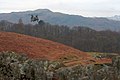
 Chinook over Rydal Water - geograph.org.uk - 1176776.jpg 640 × 427; 43 KB
-
 Chinook Playing Over Rydal Water - geograph.org.uk - 1175579.jpg 640 × 427; 39 KB
-
 Open door - geograph.org.uk - 1174789.jpg 400 × 600; 65 KB
-
 Revisit to the gun emplacement - geograph.org.uk - 1175782.jpg 640 × 426; 116 KB
-
 Church - geograph.org.uk - 1179825.jpg 640 × 480; 92 KB
-
 Church - geograph.org.uk - 1179828.jpg 640 × 480; 83 KB
-
 Church Inn, Bell Lane - geograph.org.uk - 1170521.jpg 640 × 417; 53 KB
-
 Church notice board, St. Dingat's - geograph.org.uk - 1171998.jpg 640 × 480; 117 KB
-
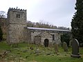
 Church of St Michael, Alnham - geograph.org.uk - 1171338.jpg 640 × 480; 127 KB
-
 Church of St Michael, Alnham - geograph.org.uk - 1171915.jpg 640 × 480; 103 KB
-
 Church Path - geograph.org.uk - 1175350.jpg 427 × 640; 208 KB
-
 Church Street - viewed from Heaton Road - geograph.org.uk - 1173242.jpg 640 × 408; 165 KB
-

-

-
 Clean - geograph.org.uk - 1174886.jpg 400 × 600; 50 KB
-
 Clearing in Deep Wood - geograph.org.uk - 1191293.jpg 640 × 426; 124 KB
-
 Clive Cottages - geograph.org.uk - 1177740.jpg 640 × 426; 96 KB
-
 Colonnade in Hill Street - geograph.org.uk - 1756521.jpg 640 × 458; 58 KB
-
-
 Como Avenue - Lingwood Avenue - geograph.org.uk - 1171044.jpg 640 × 480; 264 KB
-
 Como Drive - Lingwood Avenue - geograph.org.uk - 1171026.jpg 640 × 480; 223 KB
-
 Como Gardens - Lingwood Avenue - geograph.org.uk - 1171031.jpg 640 × 480; 259 KB
-
 Como Grove - Lingwood Avenue - geograph.org.uk - 1171049.jpg 640 × 480; 231 KB
-
 Coniston Grove - Smith Lane - geograph.org.uk - 1172315.jpg 640 × 419; 159 KB
-
 Coniston Grove - Wheatlands Drive - geograph.org.uk - 1172492.jpg 640 × 436; 109 KB
-
 Cottage at Lady Halton - geograph.org.uk - 1180309.jpg 640 × 426; 115 KB
-
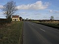
 Cottage at the side of the road - geograph.org.uk - 1171136.jpg 640 × 379; 86 KB
-
 Cottage in Village - geograph.org.uk - 1801248.jpg 1,600 × 1,200; 703 KB
-
 Cottage on Lower Wood Road - geograph.org.uk - 1175747.jpg 640 × 426; 104 KB
-
 Cottage, The Poles - geograph.org.uk - 1175772.jpg 640 × 426; 68 KB
-
 Cottages at Lady Halton - geograph.org.uk - 1180355.jpg 640 × 426; 106 KB
-
 Cotteridge - Heath Road - geograph.org.uk - 1171622.jpg 640 × 480; 142 KB
-
 Country crossroads - geograph.org.uk - 1170630.jpg 640 × 480; 88 KB
-

-

-
 Cradley Road, Netherton - geograph.org.uk - 1173402.jpg 640 × 498; 84 KB
-
 Cradley Road, Netherton - geograph.org.uk - 1173404.jpg 640 × 428; 76 KB
-
 Crailinghall Farm - geograph.org.uk - 1170616.jpg 640 × 480; 71 KB
-
 Cricket Ground - geograph.org.uk - 1172927.jpg 640 × 480; 53 KB
-
 Croft Road, Torquay - geograph.org.uk - 1176749.jpg 640 × 480; 113 KB
-
 Cross Keys Hotel - geograph.org.uk - 1755567.jpg 640 × 470; 65 KB
-
 Cross Keys, Skipton.jpg 640 × 480; 57 KB
-
 Crossroads, Phocle Green - geograph.org.uk - 1171698.jpg 640 × 480; 105 KB
-

-
 Cushat Law from Bush Knowe - geograph.org.uk - 1171040.jpg 640 × 480; 64 KB
-
 Cutting roadside hedges, Holton - geograph.org.uk - 1172122.jpg 640 × 480; 176 KB
-

-

-
 Daisy Hill Back Lane - Smith Lane - geograph.org.uk - 1172466.jpg 640 × 480; 289 KB
-

-

-
 Dark Water Pond in Hall Wood - geograph.org.uk - 1178309.jpg 640 × 481; 118 KB
-
 Dartmouth - Museum - panoramio.jpg 3,072 × 2,304; 1.07 MB
-
 Dead tree - geograph.org.uk - 1189873.jpg 640 × 426; 108 KB
-
 Deepwood - geograph.org.uk - 1191290.jpg 640 × 426; 83 KB
-
 Deepwood Farm - geograph.org.uk - 1189854.jpg 640 × 426; 83 KB


_Spring_Usher_(Agriopis_leucophaearia)_(3294930300).jpg)


_-_geograph.org.uk_-_1622388.jpg)


_-_geograph.org.uk_-_1171784.jpg)


_-_geograph.org.uk_-_1175817.jpg)


