Category:United Kingdom photographs taken on 2007-07-02
Jump to navigation
Jump to search

Subcategories
This category has only the following subcategory.
Media in category "United Kingdom photographs taken on 2007-07-02"
The following 200 files are in this category, out of 271 total.
(previous page) (next page)-
 "The Square", Minster, Thanet, Kent - geograph.org.uk - 484506.jpg 640 × 347; 83 KB
-
 "Union Mill", Sabden - geograph.org.uk - 486435.jpg 640 × 480; 172 KB
-
 "Victoria Mill", Sabden - geograph.org.uk - 486432.jpg 480 × 640; 150 KB
-
 'Jeanie Johnston' in Belfast - geograph.org.uk - 641171.jpg 640 × 480; 77 KB
-
 A better class of rubbish - geograph.org.uk - 485197.jpg 480 × 640; 86 KB
-
 A6 near Scalesceugh - geograph.org.uk - 484078.jpg 640 × 459; 143 KB
-
 A61 Barnsley Road to Barnsley - geograph.org.uk - 483758.jpg 640 × 476; 84 KB
-
 Abercromby Tomb - geograph.org.uk - 483713.jpg 475 × 640; 331 KB
-

-

-

-
 Arable Field Near Dunsdale Farm - geograph.org.uk - 484316.jpg 427 × 640; 93 KB
-
 Argynnis paphia - geograph.org.uk - 1281065.jpg 640 × 532; 89 KB
-
 Arklow Rogue - geograph.org.uk - 485128.jpg 640 × 429; 64 KB
-
 Arlescott Farm - geograph.org.uk - 484135.jpg 640 × 480; 159 KB
-
 Arradoul - geograph.org.uk - 483805.jpg 640 × 423; 197 KB
-
 At anchor off Bangor (3) - geograph.org.uk - 484165.jpg 640 × 427; 56 KB
-
 Higher Water Level in Barton Beck - geograph.org.uk - 483605.jpg 480 × 640; 190 KB
-
 Battle of the Somme Parade, Omagh - geograph.org.uk - 484936.jpg 640 × 480; 150 KB
-
 Battle of the Somme Parade, Omagh - geograph.org.uk - 484937.jpg 640 × 480; 78 KB
-
 Battle of the Somme Parade, Omagh - geograph.org.uk - 484939.jpg 640 × 480; 74 KB
-
 Battle of the Somme Parade, Omagh - geograph.org.uk - 484940.jpg 640 × 480; 68 KB
-
 Battle of the Somme Parade, Omagh - geograph.org.uk - 484941.jpg 640 × 480; 69 KB
-
 Battle of the Somme Parade, Omagh - geograph.org.uk - 484942.jpg 640 × 480; 74 KB
-
 Battle of the Somme Parade, Omagh - geograph.org.uk - 484943.jpg 640 × 480; 59 KB
-
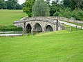 Bladon Bridge - geograph.org.uk - 676860.jpg 640 × 480; 103 KB
-
 Boyndie - geograph.org.uk - 483788.jpg 640 × 413; 227 KB
-
 Boyndie Old Kirk.jpg 640 × 427; 252 KB
-
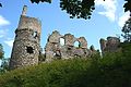
 Boyne Castle - geograph.org.uk - 483743.jpg 640 × 427; 274 KB
-
 Boyne Castle - geograph.org.uk - 483749.jpg 640 × 427; 240 KB
-
 Boyne Castle - geograph.org.uk - 483751.jpg 640 × 427; 256 KB
-
 Boyne Castle - geograph.org.uk - 483760.jpg 427 × 640; 304 KB
-
 Boyne Castle - geograph.org.uk - 483763.jpg 640 × 427; 304 KB
-
 Boyne Castle - geograph.org.uk - 483767.jpg 427 × 640; 321 KB
-
 Boyne Castle - geograph.org.uk - 483769.jpg 427 × 640; 292 KB
-
 Boyne Castle - geograph.org.uk - 483770.jpg 427 × 640; 246 KB
-
 Boyne Castle - geograph.org.uk - 483775.jpg 427 × 640; 296 KB
-
 Brahan Seer Memorial - geograph.org.uk - 486931.jpg 640 × 480; 126 KB
-
 Bridge Street - geograph.org.uk - 483686.jpg 640 × 408; 271 KB
-
 Bridge Street - geograph.org.uk - 483693.jpg 640 × 427; 277 KB
-
 Brunel Road - geograph.org.uk - 483661.jpg 640 × 480; 48 KB
-
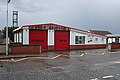 Buckie Fire Station - geograph.org.uk - 483799.jpg 640 × 427; 219 KB
-
 Caledonian Canal - geograph.org.uk - 488574.jpg 640 × 476; 219 KB
-
 Cast Iron Headstone - geograph.org.uk - 484146.jpg 640 × 480; 193 KB
-
 Castell Rhuddlan o'r bont - geograph.org.uk - 484400.jpg 640 × 475; 54 KB
-
 Cefn y Galchen - geograph.org.uk - 492257.jpg 640 × 459; 68 KB
-
 Church Street - geograph.org.uk - 483514.jpg 640 × 427; 279 KB
-
 Church Street - geograph.org.uk - 483660.jpg 640 × 427; 255 KB
-
 Church Street - geograph.org.uk - 483666.jpg 640 × 427; 255 KB
-
 Common Blue (Polyommatus icarus) - geograph.org.uk - 699734.jpg 640 × 480; 50 KB
-
 Convoy, Parham Airfield - geograph.org.uk - 960721.jpg 640 × 384; 45 KB
-
 Corarsik Track, Glen Massan - geograph.org.uk - 483436.jpg 640 × 480; 157 KB
-
 Cox's meadow flood storage basin. - geograph.org.uk - 1122919.jpg 640 × 480; 284 KB
-
 Crawley Baptist Church - geograph.org.uk - 548005.jpg 640 × 427; 73 KB
-
 Damhead - geograph.org.uk - 483838.jpg 640 × 427; 178 KB
-
 Demolition of flats, Croxteth, Liverpool - geograph.org.uk - 491290.jpg 621 × 640; 140 KB
-
 Deskford Kirk - geograph.org.uk - 483483.jpg 640 × 351; 217 KB
-
 Deskford Kirk - geograph.org.uk - 483491.jpg 298 × 640; 182 KB
-
 Deskford Kirk - geograph.org.uk - 483496.jpg 640 × 415; 241 KB
-
 Deskford Kirkyard - geograph.org.uk - 483473.jpg 640 × 427; 269 KB
-
 Dock Tower - geograph.org.uk - 484279.jpg 427 × 640; 54 KB
-
 Dornoch, Cathedral and Fountain - geograph.org.uk - 486911.jpg 480 × 640; 131 KB
-
 Dunsdale Farm - geograph.org.uk - 484285.jpg 640 × 427; 73 KB
-
 Durham Indoor Bowling Club - geograph.org.uk - 483561.jpg 640 × 340; 66 KB
-
 Dyce bowling club - geograph.org.uk - 483502.jpg 640 × 426; 99 KB
-
 Eaglescliffe station - geograph.org.uk - 483952.jpg 640 × 480; 100 KB
-
 East Church Street - geograph.org.uk - 483733.jpg 640 × 427; 256 KB
-
 The church tower - geograph.org.uk - 484295.jpg 480 × 640; 115 KB
-
 Egglescliffe Parish Hall - geograph.org.uk - 485206.jpg 640 × 480; 103 KB
-
 Enzie - geograph.org.uk - 483848.jpg 640 × 427; 194 KB
-
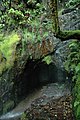 Escape Cave - geograph.org.uk - 483639.jpg 426 × 640; 138 KB
-
 Fishing at Newmillerdam - geograph.org.uk - 483548.jpg 640 × 480; 100 KB
-
 Flowers on the verge - geograph.org.uk - 483484.jpg 480 × 640; 463 KB
-
 Fordyce Castle - geograph.org.uk - 483701.jpg 640 × 406; 229 KB
-
 Fordyce Joiner's Workshop - geograph.org.uk - 483673.jpg 640 × 427; 257 KB
-
 Fordyce Joiner's Workshop - geograph.org.uk - 483739.jpg 640 × 427; 276 KB
-
 From the west bank to Hill Top - geograph.org.uk - 483695.jpg 640 × 480; 93 KB
-
 Fuar Deas - geograph.org.uk - 483680.jpg 520 × 640; 309 KB
-
 George and Dragon Inn - geograph.org.uk - 485171.jpg 640 × 480; 174 KB
-
 Glenhead Farm - geograph.org.uk - 483545.jpg 640 × 480; 51 KB
-
 Grand Princess - geograph.org.uk - 485125.jpg 640 × 360; 56 KB
-

-

-

-
 Haymarket Road (back of pub) - geograph.org.uk - 483623.jpg 640 × 480; 43 KB
-
 Haymarket Road - geograph.org.uk - 483628.jpg 640 × 480; 48 KB
-
 Headingley War Memorial - Otley Road - geograph.org.uk - 483521.jpg 404 × 640; 35 KB
-
 Highland Laddie Inn - geograph.org.uk - 484490.jpg 640 × 480; 119 KB
-
 Hook Norton Brewery - geograph.org.uk - 552554.jpg 640 × 480; 56 KB
-
 Horses - geograph.org.uk - 486105.jpg 640 × 480; 183 KB
-
 Hugh llewelyn 43 079 (5657242991).jpg 2,592 × 1,944; 1.27 MB
-
 Inside Mountain Chapel Memorial Garden - geograph.org.uk - 952767.jpg 640 × 480; 116 KB
-
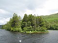 Island in Loch Oich - geograph.org.uk - 488565.jpg 640 × 475; 247 KB
-
 Ivy Cottages, overlooking the green - geograph.org.uk - 485158.jpg 640 × 480; 105 KB
-
 Road Flooded near College Farm - geograph.org.uk - 483455.jpg 640 × 430; 117 KB
-
 Loch Culag, Lochinver - geograph.org.uk - 485510.jpg 640 × 426; 71 KB
-
 Loch Stack and Arkle - geograph.org.uk - 1438251.jpg 640 × 427; 54 KB
-
 Lock at Fort Augustus - geograph.org.uk - 489094.jpg 640 × 480; 273 KB
-
 Lone tree at Hole-in-the-Wall - geograph.org.uk - 483519.jpg 480 × 640; 399 KB
-
 Lychgate - geograph.org.uk - 484149.jpg 640 × 480; 118 KB
-
 Mare Gratia and Emerald Gratia (2) - geograph.org.uk - 652892.jpg 640 × 371; 72 KB
-
 Mare Gratia and Emerald Gratia - geograph.org.uk - 485120.jpg 640 × 295; 54 KB
-

-
 Memorial to A. W. Hughes- Corris - geograph.org.uk - 483520.jpg 426 × 640; 105 KB
-
 "The Attic", Minster, Thanet, Kent - geograph.org.uk - 484327.jpg 640 × 421; 93 KB
-
 Modern flats, West Strand, Portrush - geograph.org.uk - 1115548.jpg 640 × 428; 85 KB
-
 Moray House - geograph.org.uk - 483801.jpg 640 × 427; 218 KB
-
 Nant Llanelen - geograph.org.uk - 484852.jpg 640 × 480; 130 KB
-
 Nether Dallachy - geograph.org.uk - 483792.jpg 640 × 418; 255 KB
-
 Newmillerdam - geograph.org.uk - 483538.jpg 640 × 480; 98 KB
-
 Newmillerdam outlet weir - geograph.org.uk - 483745.jpg 640 × 468; 97 KB
-
 Newmillerdam with Memorial Cross - geograph.org.uk - 483531.jpg 480 × 640; 63 KB
-
 NewmillerdamBoathouse(JohnFielding)Jul2007.jpg 640 × 476; 132 KB
-
 Nursling Church - geograph.org.uk - 491596.jpg 640 × 480; 159 KB
-
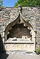 Ogilvy Tomb - geograph.org.uk - 483723.jpg 439 × 640; 302 KB
-
 Oilseed Rape (Canola) - geograph.org.uk - 483676.jpg 640 × 480; 126 KB
-
 Old Bridge, Dornoch - geograph.org.uk - 486918.jpg 640 × 480; 133 KB
-
 Old Place of Mochrum, from garden - geograph.org.uk - 920765.jpg 640 × 480; 99 KB
-
 Omagh New Integrated School - geograph.org.uk - 483442.jpg 640 × 293; 38 KB
-
 Omagh New Integrated School - geograph.org.uk - 483444.jpg 640 × 480; 86 KB
-

-
 Path from Much Wenlock - geograph.org.uk - 484121.jpg 640 × 480; 160 KB
-
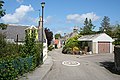
 Pathhead - geograph.org.uk - 483853.jpg 640 × 427; 233 KB
-
 Pen-Rhiw - geograph.org.uk - 483522.jpg 640 × 349; 70 KB
-
 Pennyhooks Lane, Watchfield - geograph.org.uk - 1120734.jpg 640 × 480; 134 KB
-
 Philippos - geograph.org.uk - 485126.jpg 640 × 291; 40 KB
-
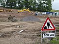
 Pipeline activity looking west - geograph.org.uk - 483511.jpg 640 × 480; 340 KB
-
 Pipeline installation heading for Tirley - geograph.org.uk - 483506.jpg 640 × 480; 323 KB
-

-
 Pipeline zigzags through the landscape - geograph.org.uk - 483501.jpg 640 × 454; 278 KB
-
 Pond Near Dunsdale Farm - geograph.org.uk - 484282.jpg 640 × 427; 70 KB
-
 Portland Hall Hotel, Carr Bank Park - geograph.org.uk - 483319.jpg 640 × 480; 135 KB
-
 Public Footpath to Dunsdale - geograph.org.uk - 484313.jpg 640 × 427; 77 KB
-
 Quackers - geograph.org.uk - 483554.jpg 640 × 480; 70 KB
-
 RAF Banff Information Board - geograph.org.uk - 483796.jpg 640 × 421; 253 KB
-
 Road junction at Portfield - geograph.org.uk - 486109.jpg 640 × 480; 166 KB
-
 Robin Hood Line, Mansfield - geograph.org.uk - 483327.jpg 640 × 480; 112 KB
-
 Saxon Cross - geograph.org.uk - 690509.jpg 479 × 640; 62 KB
-
 Sheep - geograph.org.uk - 486401.jpg 640 × 480; 199 KB
-
 Sheep at the Cattle Market Ross-on-Wye - geograph.org.uk - 483471.jpg 640 × 423; 292 KB
-
 Sheep shelter beneath a hawthorn tree - geograph.org.uk - 483978.jpg 640 × 491; 424 KB
-
 Signal Box at Crawley (geograph 551375).jpg 427 × 640; 99 KB
-
 Smirack - geograph.org.uk - 483809.jpg 640 × 427; 226 KB
-
 Smirack - geograph.org.uk - 483811.jpg 640 × 349; 178 KB
-
 Smirack - geograph.org.uk - 483814.jpg 640 × 427; 207 KB
-
 Somerset House and Waterloo Bridge, London.jpg 1,280 × 694; 295 KB
-
 St Dominic Sq - geograph.org.uk - 483525.jpg 640 × 480; 66 KB
-
 St Dominic Sq back of shops view - geograph.org.uk - 483539.jpg 640 × 480; 86 KB
-
 St Dominic Sq Car park - geograph.org.uk - 483532.jpg 640 × 480; 76 KB
-
 St Dominic Sq Car park - geograph.org.uk - 483636.jpg 640 × 480; 50 KB
-
 St Materiana's Church, Tintagel - geograph.org.uk - 487084.jpg 640 × 480; 132 KB
-

-
 St Tarquin's Kirk - geograph.org.uk - 483708.jpg 427 × 640; 249 KB
-
 Storage Tanks - geograph.org.uk - 484140.jpg 640 × 480; 121 KB
-
 The "Alpha" at Bangor - geograph.org.uk - 483768.jpg 640 × 427; 82 KB
-
 The "Bonny and Kelly" at Bangor - geograph.org.uk - 483791.jpg 635 × 422; 91 KB
-

-
 The A61 Barnsley Road - geograph.org.uk - 483750.jpg 640 × 480; 74 KB
-
 The Boathouse Newmillerdam - geograph.org.uk - 483547.jpg 640 × 480; 91 KB
-
 The Bridge over Bushcliff Beck - geograph.org.uk - 483603.jpg 640 × 480; 124 KB
-
 The bridge over the stream. - geograph.org.uk - 483655.jpg 640 × 480; 145 KB
-

-
 The churchyard at Egglescliffe - geograph.org.uk - 484292.jpg 640 × 480; 149 KB
-
 The Gatehouse Newmillerdam. - geograph.org.uk - 483534.jpg 640 × 480; 114 KB
-
 The George Hotel, Crawley.jpg 640 × 427; 68 KB
-
 The Knowes - geograph.org.uk - 483505.jpg 640 × 427; 233 KB
-
 The Link - geograph.org.uk - 483559.jpg 640 × 474; 132 KB
-
 The lone oak tree in summer - geograph.org.uk - 483601.jpg 640 × 480; 53 KB
-

-

-
 The North Pier, Bangor (4) - geograph.org.uk - 483781.jpg 640 × 427; 75 KB
-
 The Old Post Office, Tintagel - geograph.org.uk - 487091.jpg 640 × 480; 191 KB
-
 The Post Office, Minster, Thanet, Kent - geograph.org.uk - 484518.jpg 640 × 429; 101 KB
-
 The Queen's Head, Stow market place - geograph.org.uk - 552560.jpg 640 × 480; 78 KB
-
 The road to Readwood - geograph.org.uk - 486440.jpg 640 × 480; 192 KB
-
 The road to Whittakers Farm - geograph.org.uk - 486438.jpg 640 × 480; 180 KB
-
 The track leaving the Dam - geograph.org.uk - 483570.jpg 640 × 480; 138 KB
-
 There must be another way in - geograph.org.uk - 486420.jpg 480 × 640; 221 KB
-
 Tintern - commemorative plaque - geograph.org.uk - 483275.jpg 640 × 435; 149 KB
-
 To Blorenge - geograph.org.uk - 484862.jpg 640 × 480; 51 KB
-

-
 Track through deciduous wood at Wragmire - geograph.org.uk - 484069.jpg 640 × 480; 195 KB
-
 Trees below Norman's Law - geograph.org.uk - 566291.jpg 640 × 480; 33 KB
-
 Control Cabin - Bystaple Lane Crossing - geograph.org.uk - 483583.jpg 480 × 640; 112 KB
-
 View across farmland near Tickenhurst - geograph.org.uk - 483588.jpg 640 × 480; 63 KB
-
 View along Loop Street, Sandwich - geograph.org.uk - 483638.jpg 480 × 640; 63 KB
-
 View from Carn-y-gorfydd car park - geograph.org.uk - 492262.jpg 640 × 480; 64 KB
-

-
 View towards disused Windmill - geograph.org.uk - 484126.jpg 640 × 480; 152 KB
-
 Village Green, Egglescliffe - geograph.org.uk - 485154.jpg 640 × 480; 154 KB
-
 Village stores, Morebattle - geograph.org.uk - 484950.jpg 640 × 480; 76 KB
-
 Boeing F-15E Strike Eagle, USA - Air Force AN1236253.jpg 1,024 × 678; 309 KB
-
 Panavia Tornado GR4A, UK - Air Force AN1236894.jpg 1,024 × 678; 289 KB
-

-

-
 Wet Monday Afternoon in Grimsby - geograph.org.uk - 483448.jpg 640 × 480; 137 KB
-
 Wheelbirks Lane - geograph.org.uk - 527378.jpg 480 × 640; 124 KB
-
 Winding road through farmland - geograph.org.uk - 483562.jpg 640 × 480; 53 KB
-
 Wrekin View - geograph.org.uk - 484132.jpg 640 × 480; 164 KB
-
 A break in the rain. - geograph.org.uk - 490824.jpg 640 × 480; 67 KB


_-_geograph.org.uk_-_484165.jpg)


_-_geograph.org.uk_-_699734.jpg)


_-_geograph.org.uk_-_483623.jpg)


.jpg)


_-_geograph.org.uk_-_652892.jpg)


Jul2007.jpg)


_-_geograph.org.uk_-_483676.jpg)


.jpg)


_-_geograph.org.uk_-_483781.jpg)


_-_geograph.org.uk_-_483643.jpg)


