Category:Unidentified maps of the United States
Jump to navigation
Jump to search
Media in category "Unidentified maps of the United States"
The following 200 files are in this category, out of 272 total.
(previous page) (next page)-
-

-

-

-

-
-
 21 of 'U.S. An Index to the United States of America, etc' (11202774416).jpg 1,872 × 1,216; 566 KB
-

-

-

-

-
 242 of 'American Indians' (11250626184).jpg 1,305 × 1,896; 433 KB
-

-

-

-

-

-
-

-

-
-
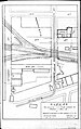
 4. Farley Camp reduced.jpg 960 × 766; 125 KB
-
 4. Farley Camp.jpg 960 × 786; 136 KB
-
 458 of 'A History of the United States of America, etc' (11248036114).jpg 1,265 × 2,028; 920 KB
-

-
 49 of 'La Vie Américaine. Ouvrage illustré, etc' (11123114126).jpg 1,208 × 707; 264 KB
-
 5. Coalwood Camp.jpg 960 × 606; 85 KB
-
 6. Kirby Camp (Middle).jpg 960 × 602; 104 KB
-
 6. Kirby Camp (Upper).jpg 960 × 613; 96 KB
-
 7. Hamill Camp.jpg 985 × 609; 66 KB
-

-
 Alabama Cavefish Range.png 241 × 345; 161 KB
-
 American Flat Mining District - DPLA - 9881293f13d4aeb4e68d5bd3d1de76ef.jpg 6,172 × 6,182; 2.09 MB
-
 Annals of the New York Academy of Sciences (1879-) (18416184191).jpg 1,730 × 2,738; 652 KB
-
 Annual report (1910) (14779295372).jpg 2,108 × 2,996; 2.24 MB
-
 ATS States Map September 23.png 2,431 × 1,695; 453 KB
-
 Basin Location.jpg 1,397 × 998; 185 KB
-
 Bell telephone magazine (1922) (14756409495).jpg 3,008 × 2,140; 1.22 MB
-
 Bia map ausschnitt.png 575 × 535; 31 KB
-
 Big North.svg 512 × 380; 65 KB
-
 Bloomsburg-Berwick-Sunbury, PA CSA 2014.jpg 893 × 479; 44 KB
-
 Blue Hill Bay temp locator.png 442 × 600; 288 KB
-
 BMOBucksRadioNetwork.svg 1,171 × 1,200; 388 KB
-
 BrewersRadioNetwork.svg 1,171 × 1,200; 392 KB
-
 Brewerton-eared-notched.jpg 335 × 237; 35 KB
-
 Bulletin (1905) (14756576396).jpg 3,242 × 2,134; 705 KB
-
 Bulletin - United States National Museum (1960) (19886559504).jpg 848 × 800; 127 KB
-
 BYUVocalPointStreamsUSA2018.jpg 8,800 × 6,800; 2.48 MB
-
 C-146 Movements (24180071479).jpg 4,200 × 3,365; 6.29 MB
-
 Carte des Etats-Unis. NYPL434879.tiff 4,584 × 5,875; 77.06 MB
-

-
 Ccmap.gif 735 × 495; 48 KB
-
 Chamberlain Woods SNA New Wiki Version.JPG 4,851 × 3,245; 4.38 MB
-
-
 Cincinnati & Eastern Railroad Through Nine Mile.JPG 723 × 965; 122 KB
-
 Cinco De Mayo 1904.svg 1,004 × 514; 26 KB
-
 Cisco Springs Field.jpg 1,020 × 821; 280 KB
-
 Clearfield-Lawrence Township Consolidation.jpg 1,378 × 897; 83 KB
-
 Coal power plants map.jpeg 762 × 460; 155 KB
-
 CobbOrigin&Endpoint.png 3,262 × 2,242; 1.89 MB
-
 CobbOriginAndEndpoint.png 3,262 × 2,242; 616 KB
-
 CobbOriginEndpoint.png 3,262 × 2,464; 637 KB
-
 Col Mar Chill Metro Stat Area.PNG 400 × 536; 12 KB
-
 Collins 2020 Ballot Access.png 5,175 × 3,762; 1.13 MB
-
 Columbus Auburn-Opelika.png 276 × 300; 50 KB
-
 Columbus Metro.PNG 400 × 464; 11 KB
-

-
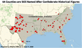 CSA Memorial Counties.png 600 × 351; 127 KB
-
 CSA State College DuBois, PA.jpg 812 × 454; 41 KB
-
 Ctf-distribution-map.jpg 1,000 × 630; 52 KB
-
 Danby State Forest Michigan Hollow and Abbot Loop (6641159967).png 1,100 × 850; 694 KB
-
 Day1otlk 20191216 1630 prt.gif 815 × 555; 27 KB
-
 Day1otlk sm.gif 190 × 129; 10 KB
-
 Day2otlk fire sep 6.gif 815 × 555; 27 KB
-
 DC & Falls Church, Va.png 390 × 730; 27 KB
-
 Delegates.svg 959 × 593; 37 KB
-
 Deschutes Canyon - Steelhead Falls WSA (33269069462).jpg 2,550 × 3,300; 1.09 MB
-
 Deschutes Canyon WSA (33041777620).jpg 2,550 × 3,300; 1.08 MB
-
 EAR-ONS-"Punishment" map.png 1,024 × 767; 1.31 MB
-
 East coast port calls.gif 600 × 784; 85 KB
-
 East of Nerstrand Private Lands Wiki Version.JPG 3,398 × 4,082; 4.8 MB
-
 East-Point-Gun-Map-1945.jpg 1,851 × 1,072; 649 KB
-
 Electrification System of New York Connecting Railroad map.png 362 × 540; 50 KB
-
 En Honor a los Granjeros de Nacionalidad Hispana - Flickr - USDAgov.jpg 1,793 × 1,200; 902 KB
-
 Eww-outisde route.jpg 464 × 419; 50 KB
-
 Example of hatches on a shaded map.png 190 × 203; 31 KB
-
 Family Radio stations.png 7,720 × 4,022; 2.72 MB
-
 Figure 1- Illustration of Base Premium Interactive Map (15291011000).jpg 2,250 × 1,951; 487 KB
-

-

-
-

-
-

-
-
-

-
-

-

-

-

-

-

-

-

-
-

-
-

-
-
-
-

-

-
-
-
-
-

-

-

-

-

-
-

-

-

-
-
-

-

-
-
-
-
 Fort Washington and the north part of New York Island. NYPL434564.tiff 4,603 × 4,884; 64.32 MB
-
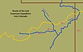 Freemont 2nd Expedition.jpg 1,200 × 749; 252 KB
-
 Geosi.png 427 × 276; 142 KB
-
 Gradikkk.png 433 × 200; 102 KB
-
 Grand Marion.PNG 641 × 465; 22 KB
-
 Grand Prairie Marion.PNG 641 × 465; 22 KB
-
 Grand-Central-NewYorkCity-USA-OpenStationMap-Screenshot.png 1,318 × 696; 225 KB
-
 GreaterTacoma-non.png 323 × 359; 7 KB
-
 Green-Star-Map-05-Feb-14.png 1,173 × 695; 151 KB
-
 Harrisburg-York-Lebanon, PA CSA 2014.jpg 875 × 479; 45 KB
-
 HarrisburgYorkLebanonCSA2014.jpg 820 × 472; 42 KB
-
 Heartland Corridor.png 732 × 407; 529 KB
-
 HFCA 1607 NPS Employees, Search And Rescue 173 U.jpg (68fa766684334d49b996dac051d9282d).jpg 7,736 × 5,128; 2.52 MB
-
 HFCA 1607 NPS Employees, Search And Rescue 185 U.jpg (05078d8a6f7f409cae0a97c550883c77).jpg 5,128 × 7,736; 2.28 MB
-
 HFCA 1607 NPS Employees, Search And Rescue 192 U.jpg (09e997baede54e52997b4e3e0e408e46).jpg 7,736 × 5,128; 3.21 MB
-
 Highlight012a graphic (highlight012a).jpg 750 × 750; 82 KB
-
 Highlight012a graphic (highlight012a).tiff 750 × 750; 129 KB
-

-
 Hurricane Sandy, FDA's Emergency Operations Center Map (8146028116).jpg 3,300 × 2,550; 2.63 MB
-

-
 I-95 Alexandria VA.svg 744 × 1,052; 115 KB
-
 Idaho Falls School District.jpg 928 × 1,212; 155 KB
-
 Idaho Legislative District 1.png 1,080 × 1,920; 198 KB
-

-

-

-

-

-

-

-

-

-

-

-
 Image taken from page 539 of 'Fra Amerika. Med Afbildninger og et Kort' (11096104536).jpg 3,542 × 2,490; 1.79 MB
-
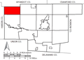
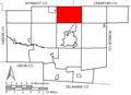
 Indiana co lines.jpg 816 × 1,055; 103 KB
-
 Indiana Map PAC Athletic (1).png 412 × 360; 6 KB
-
 Indiana Map PAC Athletic.png 806 × 1,242; 20 KB
-
 Indiana Map Southern Roads.png 250 × 368; 37 KB
-
 Inland navigation system.png 500 × 541; 250 KB
-
 Interstate 895.jpg 1,002 × 604; 242 KB
-
 LADEE Launch Viewing Map - Elevation (9671256629).jpg 1,306 × 1,133; 430 KB
-

-
 Life is Strange 2 Map (USA West Coast).png 730 × 1,010; 1.64 MB
-

-
 Louisville-Southern Indiana Bridges.png 611 × 539; 704 KB
-
 Mansfield Bucyrus Metro Area.PNG 248 × 248; 5 KB
-

-
 Map of Hodge Residence Location in Shreveport Louisiana.jpg 2,236 × 2,200; 1.76 MB
-
 Map of OHSAA Regions.png 749 × 795; 19 KB
-
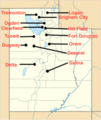 Map of prisoner of war camps in Utah.png 512 × 608; 125 KB
-
 Map of SERC area.png 826 × 941; 134 KB
-
 Map of Tennessee highlighting Metro Nashville.png 300 × 75; 11 KB
-
 Map of the northern parts of the United States of America (1804).jpg 5,530 × 3,888; 5.34 MB
-
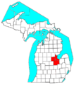 Map of the Saginaw, Midland, and Bay City Metro Area.png 435 × 497; 44 KB
-
 MAP-Pages-from-North-Cascades-Ecosystem-Grizzly-Bear-Restoration-Plan-EIS-NPS-2.jpg 2,252 × 3,047; 889 KB
-
 Mapa casa.jpg 220 × 409; 41 KB
-
 MapClassificationBreaks.PNG 367 × 735; 120 KB
-
 Marbled Sculpin Range.jpg 3,300 × 2,550; 1,015 KB
-

-
 MEGov94Counties.png 689 × 1,000; 70 KB
-
 Menards States.png 631 × 359; 55 KB
-
 Midatlantic map.png 5,400 × 3,586; 1.21 MB
-
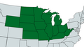
 MidwesternLegislatures2020.png 1,244 × 980; 18 KB
-
 Minnesota Conference District Map.jpg 2,238 × 1,554; 1.28 MB
%27_(11281661896).jpg)
%27_(11305423964).jpg)
.jpg)
%27_(11228487684).jpg)
%27_(11217991856).jpg)
%27_(11085023424).jpg)
.jpg)
%27_(11006694223).jpg)
.jpg)
_Annual_Report_on_the_Geology_of_the_State_of_Vermont%27_(11024518294).jpg)
%27_(11304395265).jpg)
.jpg)
%27_(11119719704).jpg)
.jpg)
%27_(11099305695)_(2).jpg)
.jpg)
%27_(11251108196).jpg)
.jpg)
.jpg)
.jpg)
.jpg)


.jpg)
.jpg)
.jpg)

.jpg)
.jpg)

.jpg)


_(18416184191).jpg)
_(14779295372).jpg)


_(14756409495).jpg)


_(14756576396).jpg)
_(19886559504).jpg)

.jpg)


_(20695196941).jpg)


.png)


.jpg)
.jpg)


.jpg)
.jpg)
_Methodology_for_Calculating_Estimated_Veteran_Population_Served_for_Skagit_County_and_Chelan_County_(15203907531).jpg)
_(2014)_(17124461638).jpg)
_Apprehensions_of_Unaccompanied_Alien_Children_(UAC),_Fiscal_Years_2009_through_2014_(20180827518).jpg)
.jpg)
.jpg)
.jpg)
.jpg)
.jpg)
.jpg)
.jpg)
.jpg)
.jpg)
.jpg)
.jpg)
.jpg)
.jpg)
.jpg)
.jpg)
.jpg)
.jpg)
.jpg)
.jpg)
.jpg)
.jpg)
.jpg)
.jpg)
.jpg)
.jpg)
.jpg)
.jpg)
.jpg)
.jpg)
.jpg)
.jpg)
.jpg)
.jpg)
.jpg)
.jpg)
.jpg)
.jpg)
.jpg)
.jpg)
.jpg)
.jpg)
.jpg)


.jpg)
.jpg)
.jpg)
.jpg)
.jpg)


.jpg)
.jpg)
.jpg)
.jpg)
.jpg)
.jpg)
.jpg)
.jpg)
.jpg)
%27_(11196420974).jpg)
%27_(16403118670).jpg)
.jpg)

.png)


.jpg)
_(14595250419).jpg)
.png)


.jpg)


.jpg)
_(14595066479).jpg)