Category:Ubuntu Local Municipality
Jump to navigation
Jump to search
local municipality in the Northern Cape, South Africa | |||||
| Upload media | |||||
| Instance of |
| ||||
|---|---|---|---|---|---|
| Location | Pixley ka Seme District Municipality, Northern Cape, RSA | ||||
| Capital | |||||
| Inception |
| ||||
| Population |
| ||||
| Elevation above sea level |
| ||||
 | |||||
Afrikaans: Die Ubuntu Plaaslike Munisipaliteit is een van die plaaslike munisipaliteite in die Pixley ka Seme-distriksmunisipaliteit in die Noord-Kaap, Suid-Afrika.
Deutsch: Ubuntu ist eine Gemeinde im Distrikt Pixley Ka Seme, Provinz Nordkap in Südafrika. Im Jahr 2001 betrug die Bevölkerung 16.368 auf einer Gesamtfläche von 20.389 km². Sitz der Gemeindeverwaltung ist Victoria West.
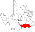
English: Ubuntu Local Municipality is a municipality in the Pixley ka Seme District Municipality of the Northern Cape province of South Africa.
Subcategories
This category has the following 3 subcategories, out of 3 total.
Media in category "Ubuntu Local Municipality"
The following 7 files are in this category, out of 7 total.
-
Map of the Northern Cape with Ubuntu highlighted (2006).svg 750 × 764; 538 KB
-
Map of the Northern Cape with Ubuntu highlighted (2011).svg 750 × 764; 392 KB
-
Map of the Northern Cape with Ubuntu highlighted (2016).svg 750 × 764; 550 KB
-
NC071 locator.svg 1,000 × 899; 287 KB
-
Ubuntu TM 1.jpg 1,139 × 854; 290 KB
-
Ubuntu-dancing.jpg 259 × 194; 12 KB
-
Ubuntu-entrance-1.jpg 220 × 229; 9 KB


