Category:Ubley
Jump to navigation
Jump to search
English: Ubley is a small village and civil parish within the Chew Valley in Bath and North East Somerset about from Bath. It is just south-east of Blagdon Lake on the A368 between Compton Martin and Blagdon.
village and civil parish in Somerset, England  | |||||
| Upload media | |||||
| Instance of | |||||
|---|---|---|---|---|---|
| Location | Bath and North East Somerset, Somerset, South West England, England | ||||
| Population |
| ||||
 | |||||
Subcategories
This category has only the following subcategory.
B
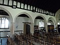
- St Bartholomew's church, Ubley (16 F)
Media in category "Ubley"
The following 153 files are in this category, out of 153 total.
-
 A restricted byway - geograph.org.uk - 501779.jpg 640 × 427; 96 KB
-
 A short walk - geograph.org.uk - 3509440.jpg 2,304 × 1,704; 1.8 MB
-
 A steeply wooded hillside on the North Face of Ubley Down - geograph.org.uk - 2103319.jpg 3,072 × 2,304; 5.47 MB
-
 Back of the chapel - geograph.org.uk - 3509441.jpg 2,304 × 1,704; 1.6 MB
-
 Blagdon Lake - geograph.org.uk - 602107.jpg 640 × 182; 26 KB
-
 Breach Farm - geograph.org.uk - 162098.jpg 640 × 426; 124 KB
-
 Bridge and stream feeding the upper reaches of Blagdon Lake - geograph.org.uk - 4850775.jpg 3,648 × 2,048; 3.29 MB
-
 Chimney near Ubley - geograph.org.uk - 2266721.jpg 3,000 × 4,000; 2.4 MB
-
 Competition tent - geograph.org.uk - 3504282.jpg 2,304 × 1,704; 1.82 MB
-
 Cook's Gully - geograph.org.uk - 2662356.jpg 2,592 × 1,944; 1.37 MB
-

-

-
 Disused chimney - geograph.org.uk - 4850761.jpg 3,648 × 2,048; 2.65 MB
-
 Drowned woodland fringing Blagdon Lake - geograph.org.uk - 4850756.jpg 3,648 × 2,048; 3.25 MB
-
 Farmland near to Chew Valley Lake - geograph.org.uk - 146996.jpg 640 × 481; 96 KB
-
 Field edge boundary to the West of Ubley - geograph.org.uk - 2103433.jpg 3,072 × 2,304; 3.24 MB
-
 Field edge boundary to the West of Ubley - geograph.org.uk - 2103442.jpg 3,072 × 2,304; 4.55 MB
-
 Field Near Cleve Farm - geograph.org.uk - 138522.jpg 640 × 426; 114 KB
-
 Footpath downhill through Ubley Wood - geograph.org.uk - 2103291.jpg 3,072 × 2,304; 5.22 MB
-
 Former miller's house, near Ubley - geograph.org.uk - 2266731.jpg 4,000 × 3,000; 2.09 MB
-

-
 Granny Bonnets in St Bart's - geograph.org.uk - 3509627.jpg 2,304 × 1,704; 1.73 MB
-

-
 Horse Boy on Breach Hill - geograph.org.uk - 162107.jpg 640 × 426; 113 KB
-
 Inside St. Bartholomew, Ubley (I) - geograph.org.uk - 3156604.jpg 480 × 640; 40 KB
-
 Inside St. Bartholomew, Ubley (II) - geograph.org.uk - 3156641.jpg 640 × 480; 72 KB
-
 Inside St. Bartholomew, Ubley (III) - geograph.org.uk - 3156651.jpg 480 × 640; 73 KB
-
 Inside St. Bartholomew, Ubley (IV) - geograph.org.uk - 3156663.jpg 640 × 480; 75 KB
-
 Meadow land to the South of Ubley - geograph.org.uk - 2103330.jpg 3,072 × 2,304; 2.74 MB
-
 Mill Chimney, Ubley - panoramio.jpg 2,112 × 2,816; 1.67 MB
-

-
 Much to read - geograph.org.uk - 3504286.jpg 1,704 × 2,304; 1.74 MB
-

-
 Snatch Farm, Snatch Lane, Ubley - geograph.org.uk - 4830853.jpg 3,776 × 2,520; 3.86 MB
-
 South of Ubley, Somerset - geograph.org.uk - 146988.jpg 640 × 481; 79 KB
-
 St Bart's, Ubley - geograph.org.uk - 3491958.jpg 1,704 × 2,304; 1.76 MB
-
 St Bartholomew's - geograph.org.uk - 3509611.jpg 1,704 × 2,304; 1.81 MB
-
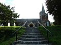
 St Bartholomew's Church, Ubley - geograph.org.uk - 2266771.jpg 2,472 × 3,296; 2.02 MB
-
 St Bartholomew's Church, Ubley - geograph.org.uk - 2266778.jpg 3,296 × 2,472; 1.9 MB
-

-
 St. Bartholomew Church, Ubley - geograph.org.uk - 5899563.jpg 4,896 × 3,672; 6.26 MB
-
 St. Bartholomew, Ubley, altar - geograph.org.uk - 3156654.jpg 640 × 455; 63 KB
-

-

-

-

-
 St. Bartholomew, Ubley, churchyard (b) - geograph.org.uk - 3156585.jpg 640 × 480; 118 KB
-

-
 St. Bartholomew, Ubley, churchyard (d) - geograph.org.uk - 3156592.jpg 640 × 480; 117 KB
-
 St. Bartholomew, Ubley, churchyard (e) - geograph.org.uk - 3156595.jpg 640 × 480; 108 KB
-
 St. Bartholomew, Ubley, entrance - geograph.org.uk - 3156594.jpg 480 × 640; 82 KB
-
 St. Bartholomew, Ubley, flowers - geograph.org.uk - 3156597.jpg 640 × 480; 52 KB
-
 St. Bartholomew, Ubley, font - geograph.org.uk - 3156633.jpg 480 × 640; 62 KB
-

-
 St. Bartholomew, Ubley, memorial (1) - geograph.org.uk - 3156623.jpg 640 × 437; 44 KB
-
 St. Bartholomew, Ubley, memorial (2) - geograph.org.uk - 3156622.jpg 640 × 480; 47 KB
-
 St. Bartholomew, Ubley, memorial (3) - geograph.org.uk - 3156627.jpg 640 × 480; 49 KB
-
 St. Bartholomew, Ubley, rear view - geograph.org.uk - 3156583.jpg 640 × 480; 84 KB
-
 St. Bartholomew, Ubley, shield - geograph.org.uk - 3156613.jpg 480 × 640; 77 KB
-
 St. Bartholomew, Ubley, shields - geograph.org.uk - 3156639.jpg 480 × 640; 58 KB
-

-
-

-

-

-
 St. Bartholomew, Ubley, steps - geograph.org.uk - 3156565.jpg 640 × 480; 83 KB
-
 St. Bartholomew, Ubley, window - geograph.org.uk - 3156645.jpg 480 × 640; 77 KB
-
 Stump seat - geograph.org.uk - 3509622.jpg 1,704 × 2,304; 2.19 MB
-
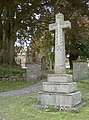
 The Cross, Ubley - geograph.org.uk - 2266816.jpg 3,000 × 4,000; 2.31 MB
-
 The northern slopes of the Mendip Hills - geograph.org.uk - 2662396.jpg 2,592 × 1,944; 1.11 MB
-
 The Old Manor, Ubley - geograph.org.uk - 2266802.jpg 3,296 × 2,472; 1.69 MB
-
 The South shoreline of Blagdon Lake - geograph.org.uk - 4850748.jpg 3,648 × 2,048; 2.59 MB
-
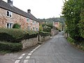 The Street, Ubley - geograph.org.uk - 2662416.jpg 2,592 × 1,944; 1.54 MB
-
 Ubley , Country Lane - geograph.org.uk - 6551410.jpg 6,000 × 4,000; 7.08 MB
-
 Ubley , Country Lane - geograph.org.uk - 6551411.jpg 6,000 × 4,000; 6.78 MB
-
 Ubley , Country Lane - geograph.org.uk - 6551412.jpg 6,000 × 4,000; 6.89 MB
-
 Ubley , Country Lane - geograph.org.uk - 6551415.jpg 6,000 × 4,000; 6.76 MB
-
 Ubley , Country Lane - geograph.org.uk - 6551418.jpg 6,000 × 4,000; 6.36 MB
-
 Ubley , Country Lane - geograph.org.uk - 6551421.jpg 6,000 × 4,000; 6.94 MB
-
 Ubley , Crop Field - geograph.org.uk - 6551451.jpg 4,000 × 6,000; 7.28 MB
-
 Ubley , Crop Field - geograph.org.uk - 6551453.jpg 6,000 × 4,000; 5.81 MB
-
 Ubley , Crop Field - geograph.org.uk - 6551454.jpg 6,000 × 4,000; 6.22 MB
-
 Ubley , Footpath - geograph.org.uk - 6551450.jpg 6,000 × 4,000; 7.93 MB
-
 Ubley , Footpath - geograph.org.uk - 6551457.jpg 6,000 × 4,000; 6.45 MB
-
 Ubley , Grassy Field - geograph.org.uk - 6551393.jpg 6,000 × 4,000; 6.09 MB
-
 Ubley , Grassy Field - geograph.org.uk - 6551401.jpg 6,000 × 4,000; 6.88 MB
-
 Ubley , Grassy Field - geograph.org.uk - 6551414.jpg 6,000 × 4,000; 6.16 MB
-
 Ubley , Grassy Field - geograph.org.uk - 6551442.jpg 6,000 × 4,000; 6.55 MB
-
 Ubley , Grassy Field - geograph.org.uk - 6551444.jpg 6,000 × 4,000; 7.34 MB
-
 Ubley , Grassy Field - geograph.org.uk - 6551445.jpg 6,000 × 4,000; 7.37 MB
-
 Ubley , Grassy Field - geograph.org.uk - 6551446.jpg 6,000 × 4,000; 7.01 MB
-
 Ubley , Grassy Field - geograph.org.uk - 6551448.jpg 6,000 × 4,000; 6.29 MB
-
 Ubley , Grassy Field - geograph.org.uk - 6551449.jpg 6,000 × 4,000; 6.98 MB
-
 Ubley , Grassy Field - geograph.org.uk - 6551460.jpg 6,000 × 4,000; 7.24 MB
-
 Ubley , Grassy Field - geograph.org.uk - 6551461.jpg 6,000 × 4,000; 8 MB
-
 Ubley , Grassy Field - geograph.org.uk - 6551462.jpg 6,000 × 4,000; 6.76 MB
-
 Ubley , Grassy Field - geograph.org.uk - 6551465.jpg 6,000 × 4,000; 6.24 MB
-
 Ubley , Grassy Field - geograph.org.uk - 6551466.jpg 6,000 × 4,000; 6.09 MB
-
 Ubley , Grassy Field - geograph.org.uk - 6551468.jpg 6,000 × 4,000; 7.17 MB
-
 Ubley , Grassy Field ^ Cattle - geograph.org.uk - 6551395.jpg 6,000 × 4,000; 7.61 MB
-
 Ubley , Grassy Field ^ Cattle - geograph.org.uk - 6551396.jpg 4,503 × 3,001; 3.11 MB
-
 Ubley , Grassy Field ^ Cattle - geograph.org.uk - 6551398.jpg 2,271 × 3,406; 2.09 MB
-
 Ubley , Grassy Field ^ Cattle - geograph.org.uk - 6551399.jpg 4,208 × 2,806; 4.48 MB
-
 Ubley , Grassy Field ^ Cattle - geograph.org.uk - 6551400.jpg 5,274 × 3,516; 5.13 MB
-
 Ubley , Grassy Field ^ Cattle - geograph.org.uk - 6551472.jpg 6,000 × 4,000; 5.78 MB
-
 Ubley , Mill House - geograph.org.uk - 6551422.jpg 6,000 × 4,000; 7.29 MB
-
 Ubley , Road - geograph.org.uk - 6551406.jpg 6,000 × 4,000; 7.32 MB
-
 Ubley , Road - geograph.org.uk - 6551423.jpg 6,000 × 4,000; 7.54 MB
-
 Ubley , Snatch Barn - geograph.org.uk - 6551417.jpg 6,000 × 4,000; 6.76 MB
-
 Ubley , Track - geograph.org.uk - 6551408.jpg 6,000 × 4,000; 7.51 MB
-
 Ubley , Track - geograph.org.uk - 6551416.jpg 6,000 × 4,000; 7.58 MB
-
 Ubley , Track - geograph.org.uk - 6551419.jpg 6,000 × 4,000; 6.48 MB
-
 Ubley , Track - geograph.org.uk - 6551458.jpg 6,000 × 4,000; 7.35 MB
-
 Ubley , Track - geograph.org.uk - 6551474.jpg 6,000 × 4,000; 6.28 MB
-
 Ubley , Track - geograph.org.uk - 6551475.jpg 6,000 × 4,000; 7.38 MB
-
 Ubley C of E Primary school - geograph.org.uk - 3504273.jpg 2,304 × 1,704; 1.58 MB
-
 Ubley Chimney - geograph.org.uk - 1211592.jpg 640 × 404; 120 KB
-
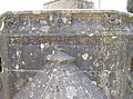
 Ubley church benchmark - geograph.org.uk - 3491952.jpg 1,704 × 2,304; 1.78 MB
-
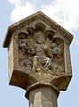
 Ubley Cross (NE face) - geograph.org.uk - 3509664.jpg 2,304 × 1,704; 1.73 MB
-
 Ubley Cross (NW face) - geograph.org.uk - 3509672.jpg 2,304 × 1,704; 1.8 MB
-
 Ubley Cross (SE face) - geograph.org.uk - 3509678.jpg 2,304 × 1,704; 1.69 MB
-
 Ubley Cross (SW face) - geograph.org.uk - 3509675.jpg 2,304 × 1,704; 1.7 MB
-
 Ubley Cross - geograph.org.uk - 3509681.jpg 1,704 × 2,304; 1.55 MB
-
 Ubley Cross - geograph.org.uk - 3509685.jpg 1,704 × 2,304; 1.18 MB
-
 Ubley cross.JPG 960 × 1,280; 190 KB
-
 Ubley Farmhouse - geograph.org.uk - 2103426.jpg 3,072 × 2,304; 2.92 MB
-
 Ubley fête 2013 - geograph.org.uk - 3504279.jpg 2,304 × 1,704; 1.66 MB
-
 Ubley Hatchery - geograph.org.uk - 1211601.jpg 640 × 479; 182 KB
-
 Ubley library - geograph.org.uk - 3509690.jpg 2,304 × 1,704; 1.13 MB
-
 Ubley Memorial - geograph.org.uk - 1211618.jpg 479 × 640; 111 KB
-
 Ubley Methodist - geograph.org.uk - 3509434.jpg 1,704 × 2,304; 1.83 MB
-
 Ubley Motor Services - geograph.org.uk - 2311709.jpg 1,024 × 768; 135 KB
-
 Ubley Park House - geograph.org.uk - 1509519.jpg 640 × 479; 125 KB
-
 Ubley sewage works - geograph.org.uk - 2103336.jpg 3,072 × 2,304; 3.7 MB
-
 Ubley village centre (1) - geograph.org.uk - 3156568.jpg 480 × 640; 64 KB
-
 Ubley village centre (2) - geograph.org.uk - 3156577.jpg 640 × 480; 86 KB
-
 Ubley village crossroads - geograph.org.uk - 3509730.jpg 2,304 × 1,704; 1.81 MB
-
 Ubley War Memorial - geograph.org.uk - 3509615.jpg 1,704 × 2,304; 2.17 MB
-
 Ubley Wood (2) - geograph.org.uk - 2103314.jpg 3,072 × 2,304; 5.49 MB
-
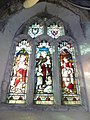
 Ubley, detail of a church window - geograph.org.uk - 3345350.jpg 480 × 640; 102 KB
-

-
 Ubley, the book exchange - geograph.org.uk - 3341713.jpg 640 × 480; 64 KB
-
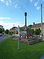
 Ubley, the cross on the little green - geograph.org.uk - 3341706.jpg 640 × 480; 62 KB
-
 Ubley, the telephone box - geograph.org.uk - 3341708.jpg 480 × 640; 72 KB
-
 War Memorial, The Green, Ubley. - panoramio.jpg 2,816 × 2,112; 3.24 MB
-
 Who are you staring at^ - geograph.org.uk - 3509601.jpg 1,704 × 2,304; 1.5 MB
-
 Wild meadow beside St Bart's - geograph.org.uk - 3509607.jpg 2,304 × 1,704; 1.65 MB
-
 Yeo River - geograph.org.uk - 162113.jpg 640 × 426; 211 KB
-
 You have been warned^ - geograph.org.uk - 4850765.jpg 3,648 × 2,048; 1.83 MB
-
 Blagdon Lake - geograph.org.uk - 134038.jpg 640 × 480; 131 KB
-
 Empty Corral - geograph.org.uk - 602092.jpg 640 × 480; 88 KB
-
 Hazel Manor Farm - geograph.org.uk - 602117.jpg 480 × 640; 131 KB
-
 Ubley Methodist Church - geograph.org.uk - 138511.jpg 426 × 640; 80 KB


_-_geograph.org.uk_-_3156604.jpg)
_-_geograph.org.uk_-_3156641.jpg)
_-_geograph.org.uk_-_3156651.jpg)
_-_geograph.org.uk_-_3156663.jpg)


_-_geograph.org.uk_-_3156607.jpg)
_-_geograph.org.uk_-_3156611.jpg)
_-_geograph.org.uk_-_3156575.jpg)
_-_geograph.org.uk_-_3156585.jpg)
_-_geograph.org.uk_-_3156590.jpg)
_-_geograph.org.uk_-_3156592.jpg)
_-_geograph.org.uk_-_3156595.jpg)


_-_geograph.org.uk_-_3156623.jpg)
_-_geograph.org.uk_-_3156622.jpg)
_-_geograph.org.uk_-_3156627.jpg)


_-_geograph.org.uk_-_3156598.jpg)
_-_geograph.org.uk_-_3156612.jpg)
_-_geograph.org.uk_-_3156638.jpg)
_-_geograph.org.uk_-_3156659.jpg)
_-_geograph.org.uk_-_3156664.jpg)


_-_geograph.org.uk_-_3509664.jpg)
_-_geograph.org.uk_-_3509672.jpg)
_-_geograph.org.uk_-_3509678.jpg)
_-_geograph.org.uk_-_3509675.jpg)


_-_geograph.org.uk_-_3156568.jpg)
_-_geograph.org.uk_-_3156577.jpg)


_-_geograph.org.uk_-_2103314.jpg)


