Category:USGS PP 174 Posted by CLIght
Jump to navigation
Jump to search
William C. Alden; Physiography and Glacial Geology of Eastern Montana and Adjacent Areas, Professional Paper 174; Geological Survey, W. C. Mendenhall, Director; United States Department of the Interior, Ray Lyman Wilbur, Secretary; United States; Government Printing Office; Washington, D.C.; 1932
Media in category "USGS PP 174 Posted by CLIght"
The following 25 files are in this category, out of 25 total.
-
 Eastern Portion of Glacier National Park (pg 104).jpg 2,293 × 2,229; 1.18 MB
-
 Fig 1 Terminal Moraine of St Mary's Glacier.jpg 856 × 482; 131 KB
-
 Fig 10 Map of the vicinity of Great Falls, Mont.jpg 1,361 × 1,813; 627 KB
-

-

-
 Fig 12 Map showing preglacial river system of northern Montana.jpg 1,050 × 827; 113 KB
-
 Fig 14 Map showing drainage of part of northern Montana at early Wisc stage.jpg 1,057 × 769; 124 KB
-
 Fig 15 Map showing post glacial drainage system of part of northern Montana.jpg 1,076 × 844; 158 KB
-
 Fig 16 Geologic section on Two Medicine Creek.jpg 838 × 408; 122 KB
-
 Fig 17 Geologic section in the Fort Belknap Reservation.jpg 678 × 406; 63 KB
-
 Fig 18 Stream diversions east of Malta Mont.jpg 1,236 × 1,992; 387 KB
-
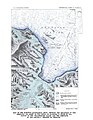
 Fig 19 Depths of water in St Mary Lake, Glacier National Park.jpg 1,364 × 583; 198 KB
-
 Fig 2 Section on St Mary River 1 mile south of Kimball, Alb.jpg 860 × 450; 145 KB
-
 Fig 3 Section on St Mary River north of Sloan's ranch, Mont.jpg 248 × 1,308; 124 KB
-
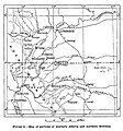 Fig 4 Map of portions of southern Alberta and Northern Montana.jpg 854 × 918; 151 KB
-
 Fig 5 Section on Belly River near Lethbridge, Alberta.jpg 434 × 760; 116 KB
-
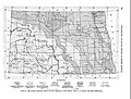 Fig 6 Map showing topographic features and drift boundaries in North Dakota.jpg 2,102 × 1,596; 941 KB
-
 Fig 7 Sections showing the preglacial valley of the Missouri.jpg 938 × 780; 176 KB
-

-
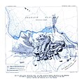
 Fig 9 Map showing the preglacial course of the Missouri River.jpg 1,028 × 1,006; 97 KB
-
 Map of Little Rocky Mountains, Mont. (pg 104).jpg 2,255 × 2,192; 776 KB
-
 Map of Region of Great Falls, Montana (pg 88).jpg 3,746 × 2,149; 1.77 MB
-
 Map of the Glendive Quadrangle (pg 80).jpg 1,623 × 2,099; 669 KB
-
 Topographic Map of a Part of the Big Horn Mtns (pg 40-41).jpg 2,465 × 2,044; 1.18 MB
-
 Topographic Map of Parts of Hill and Blaine Counties (pg 104).jpg 3,815 × 1,894; 1.61 MB
.jpg)


.jpg)
.jpg)
.jpg)
.jpg)
.jpg)