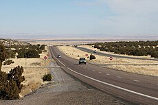
Category:U.S. Route 89 in Arizona
Jump to navigation
Jump to search
 | number: | (eighty-nine) |
|---|---|---|
| U.S. Highways in Arizona: | 70 · 80 · 89 · 91 · 93 · 95 |
section of U.S. Numbered Highway in Coconino County, Arizona, United States | |||||
| Upload media | |||||
| Instance of | |||||
|---|---|---|---|---|---|
| Location | Coconino County, Arizona | ||||
| Transport network | |||||
| Connects with | |||||
| Owned by | |||||
| Maintained by | |||||
| Inception |
| ||||
| Length |
| ||||
| Terminus | |||||
 | |||||
English: Media related to U.S. Route 89 in Arizona, a 136.49-mile (219.66 km) section of U.S. Numbered Highway in Coconino County, Arizona, United States.
Subcategories
This category has the following 5 subcategories, out of 5 total.
Media in category "U.S. Route 89 in Arizona"
The following 39 files are in this category, out of 39 total.
-
US 89T.svg 750 × 600; 6 KB
-
Arizona State Route 389 map.svg 1,001 × 586; 89 KB
-
Arizona State Route 564 map.svg 1,001 × 586; 74 KB
-
Arizona State Route 67 map.svg 1,001 × 586; 76 KB
-
Arizona State Route 98 map.svg 1,001 × 586; 75 KB
-
Arizona, U.S. Route 89 near Page.jpg 2,961 × 1,974; 2.33 MB
-
Black Mesa and Lake Powell RR Map.png 1,500 × 1,200; 109 KB
-
BridgeCameron (cropped).jpg 2,450 × 350; 707 KB
-
BridgeCameron.jpg 2,816 × 2,120; 3.56 MB
-
Coming off Kaibab Plateau - Flickr - brewbooks (1).jpg 3,264 × 2,448; 3.62 MB
-
Coming off Kaibab Plateau - Flickr - brewbooks.jpg 2,592 × 2,054; 2.56 MB
-
Echo cliffs04.jpg 2,520 × 1,680; 3.02 MB
-
Echo cliffs06.jpg 2,280 × 1,070; 1.97 MB
-
Flagstaff AZ USA 315 10.JPG 1,600 × 947; 1.47 MB
-
Harry Raab photo (NBY 436600).jpg 819 × 525; 64 KB
-
Interstate 40 Arizona.jpg 4,320 × 3,240; 4.82 MB
-
Lac powell 2016 Glen Canyon Bridge and Visitor Center.JPG 4,896 × 2,752; 5.54 MB
-
Lac powell 2016 Glen Canyon Dam (4).JPG 4,034 × 2,277; 3.27 MB
-
Layers - panoramio (2).jpg 1,920 × 874; 755 KB
-
Milton ave Flagstaff.JPG 1,245 × 658; 356 KB
-
Pohled ze silnice US 89 - panoramio.jpg 3,872 × 2,592; 3.29 MB
-
Road (6225529941).jpg 3,840 × 2,423; 5.31 MB
-
Stormy Arizona Route 89 (128206753).jpeg 2,048 × 1,365; 721 KB
-
Tanner's Crossing - Little Colorado River - panoramio.jpg 3,000 × 4,000; 4.27 MB
-
U.S. Route 89, Arizona.jpg 2,582 × 1,718; 1.04 MB
-
US 89 (AZ 1960 north).svg 2,160 × 2,065; 7 KB
-
US 89 1963 (AZ).svg 2,160 × 2,065; 10 KB
-
US 89 Arizona 1926.svg 1,485 × 1,440; 30 KB
-
US 89 Arizona 1956 North.svg 372 × 384; 22 KB
-
US 89 Arizona 1956 South.svg 372 × 384; 19 KB
-
US 89 Arizona 1956.svg 384 × 384; 13 KB
-
US 89 End.jpg 8,160 × 6,144; 7.63 MB
-
US 89 in Arizona.jpg 3,008 × 2,000; 2.38 MB
-
US 89 Overlook Towards Marble Canyon and Vermillion Cliffs, Arizona (21228945732).jpg 4,608 × 3,456; 5.54 MB
-
US Route 89 (AZ) map.png 922 × 579; 62 KB
-
US Route 89, Arizona.jpg 3,008 × 2,000; 5.57 MB
-
US XX Arizona 1956 North.svg 372 × 384; 21 KB
-
US XX Arizona 1956 South.svg 372 × 384; 18 KB
-
VermilionCliffsComposite5695.jpg 4,950 × 860; 2.67 MB


