Category:U.S. Route 69 in Oklahoma
Jump to navigation
Jump to search
section of U.S. Numbered Highway in Oklahoma, United States   _map.png) | |||||
| Upload media | |||||
| Instance of | |||||
|---|---|---|---|---|---|
| Location | Oklahoma | ||||
| Transport network |
| ||||
| Owned by | |||||
| Maintained by | |||||
| Length |
| ||||
| Terminus |
| ||||
| |||||
English: Media related to U.S. Route 69 in Oklahoma (US 69), a 260.82-mile (419.75 km) section of Numbered Highway in Oklahoma, United States, that connecets US 69/U.S. Route 75 in Texas with US 69/K‑7 in Kansas.
Subcategories
This category has only the following subcategory.
Media in category "U.S. Route 69 in Oklahoma"
The following 16 files are in this category, out of 16 total.
-
 Downtown McAlester.jpg 1,600 × 1,200; 832 KB
-
 Durant hwy 69 75.jpg 3,264 × 2,448; 1.32 MB
-
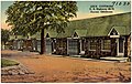 Lee's Cottages, U.S. Highway 69 - 75, Durant, Oklahoma (71030).jpg 3,298 × 2,097; 3.17 MB
-
 Oklahoma State Highway 3.jpg 1,762 × 1,323; 1.06 MB
-
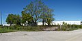
 Picherconnell.jpg 636 × 480; 117 KB
-
 Riviera-Courts Motel.jpg 4,972 × 2,497; 3.66 MB
-
 U.S. Rte 69 at East 1st St, Picher, Oklahoma, looking south, August 2023.jpg 2,000 × 1,333; 501 KB
-
 US 69 (Oklahoma) map.png 2,205 × 1,286; 90 KB
-
 US 69 alternate.jpg 1,600 × 1,200; 628 KB
-
 US 69 Craig Co.jpg 1,600 × 1,200; 395 KB
-
 US 69 Mayes Co.jpg 610 × 545; 78 KB
-
 US 69 Oklahoma 1926.svg 1,485 × 1,440; 30 KB
-
 US 69, 9 mi to Pryor.jpg 341 × 316; 41 KB
-
 US-62 69 Muskogee.jpg 1,600 × 1,200; 343 KB
-
 US69 South at OK10 Signs to I-44.jpg 3,600 × 2,400; 3.31 MB
-
 US75sUS69sRoadSigns-NearOK91 (40082701525).jpg 2,400 × 1,600; 1.41 MB

.jpg)


.jpg)