Category:Trig points
Jump to navigation
Jump to search
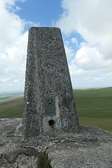
A Trigonometrical station, triangulation pillar or trig point is a fixed surveying station for the geodetic surveying and other surveying projects on nearby area. They are generally known as Trigonometrical stations in North America and trig points in the United Kingdom and Australia; triangulation pillar is the more formal term for the concrete columns found in the UK.
See also: Category:Kilometre Zero
Català: Vèrtex geodèsic
Français : Points géodésiques
日本語: 三角点は三角測量に用いる際に経度・緯度・標高の基準になる点。
Português: Vértices/marcos geodésicos
fixed surveying station used in geodetic surveying | |||||
| Upload media | |||||
| Subclass of |
| ||||
|---|---|---|---|---|---|
| Has use | |||||
| Different from | |||||
| Said to be the same as | Benchmark (levelling) | ||||
| |||||
Subcategories
This category has the following 6 subcategories, out of 6 total.
Pages in category "Trig points"
This category contains only the following page.
Media in category "Trig points"
The following 61 files are in this category, out of 61 total.
-
20150929 Baken1 Willemsduin Schiermonnikoog.jpg 3,672 × 4,896; 2.47 MB
-
20150929 Baken2 Willemsduin Schiermonnikoog.jpg 3,672 × 4,896; 3.33 MB
-
20180919 Baken Willemsduin1 Schiermonnikoog.jpg 3,456 × 5,184; 2.8 MB
-
Arakaldo.jpg 4,000 × 2,256; 5.82 MB
-
Aufgeklebter Vermessungspunkt in historischem Gebäude DSCF3466.jpg 3,488 × 2,616; 4.54 MB
-
Baken2 Willemsduin.jpg 1,813 × 2,720; 295 KB
-
Bald Rock Trig Station and Stone Pillar.jpg 4,032 × 2,268; 3.09 MB
-
Barton End trigpoint.jpg 4,000 × 3,000; 5.53 MB
-
Berlin, Messpunkt am Zeughaus NIK 4378.jpg 6,000 × 4,000; 9.75 MB
-
Bolehill (Trig Point), Triangulation Point, Derbyshire (51604288358).jpg 4,160 × 3,120; 2.24 MB
-
Estación n35 de triangulación.JPG 4,288 × 2,848; 1.7 MB
-
Triangulum point Fortepan 71091.jpg 6,740 × 7,887; 10.42 MB
-
Geodetisch signaal - 375625 - onroerenderfgoed.jpg 1,627 × 2,446; 340 KB
-
Geodetisch station1855.jpg 960 × 1,280; 534 KB
-
Grenzstein mit Kreuz, Neusiedlersee, Grenze Österreich - Ungarn.jpg 1,500 × 997; 636 KB
-
HDNP-Attenhausen.jpg 1,536 × 2,560; 1.2 MB
-
HDNP-Johannbrunn.jpg 2,560 × 1,536; 1.45 MB
-
HDNP-Schweitenkirchen.jpg 2,560 × 1,536; 994 KB
-
Hito Pico El Campanario.jpg 2,448 × 3,264; 4.4 MB
-
Jesuri.jpg 4,080 × 3,072; 4.96 MB
-
Kikinda Wikivoyage Banner.jpg 3,656 × 530; 230 KB
-
Kolitza.jpg 4,080 × 3,072; 6.18 MB
-
Marco geodésico do Pico da Grota.jpg 719 × 701; 96 KB
-
Marco geodésico IBGE 2895J - SP255 180709 REFON 4.JPG 771 × 515; 234 KB
-
Marco geodésico.jpg 3,120 × 4,160; 3.74 MB
-
Mericka vez pudorys.jpg 1,246 × 1,518; 109 KB
-
Merryong Geodetic Station 2.jpg 3,648 × 2,736; 1.69 MB
-
Merryong Geodetic Station.jpg 3,648 × 2,736; 1.08 MB
-
Polygonlochstein2.jpg 2,592 × 1,936; 2.96 MB
-
Remains of an old earth mound with a cross (detail).jpg 1,193 × 804; 190 KB
-
Remains of an old earth mound with a cross.jpg 1,472 × 935; 215 KB
-
Shymbulak Valley - survey marker - CIMG8499.JPG 1,600 × 1,200; 683 KB
-
Signalizacni pyramida se zvysenym postavenim stroje.svg 1,052 × 744; 14 KB
-
Signalizacni pyramida.svg 1,052 × 744; 3 KB
-
Sikavuori Jalasjärvi 4.jpg 480 × 640; 187 KB
-
Topographical landmark Arch Triumph Bucharest.jpg 6,000 × 4,000; 5.62 MB
-
TP auf dem Stegskopf.JPG 3,888 × 2,592; 5.43 MB
-
TP Bodenpunkt und Triangulierungspfeiler.jpg 1,200 × 1,600; 494 KB
-
Triang.Punkt Pfeiler Pyr.jpg 365 × 210; 27 KB
-
Triangulation Pillar Symbol green.svg 354 × 354; 408 bytes
-
Triangulation Pillar Symbol.svg 354 × 354; 408 bytes
-
Trig (6959981575).jpg 1,926 × 1,157; 896 KB
-
Trig Point (3888091694).jpg 1,663 × 2,328; 3.41 MB
-
Trig point atop Mount Wellington, Tasmania.jpg 2,749 × 3,840; 3.89 MB
-
Trig Point in Cot-Town Wood.jpg 3,120 × 4,160; 3.23 MB
-
Trig point, Capplestone Gate - geograph.org.uk - 1760172.jpg 4,000 × 3,000; 2.89 MB
-
Trig Point, Israel.JPG 2,816 × 2,112; 1.09 MB
-
Trigonometrical Station on Mt Gibraltar, NSW, Australia.jpg 4,000 × 6,000; 4.63 MB
-
Trigonometrischer Punkt.jpg 1,024 × 1,536; 463 KB
-
Vainatrakio piliakalnis. Sovietinis geodezinis ženklas.JPG 2,432 × 3,648; 2.03 MB
-
Vermarkungsnagel.jpg 800 × 706; 85 KB
-
Vermessungspunkt mit Schutzabdeckung DSCF3444.jpg 2,616 × 3,488; 4.45 MB
-
Vermessungspunkt mit Schutzkappe aufgeschraubt DSCF3362.jpg 3,488 × 2,616; 4.4 MB
-
Vermessungsturm 01.jpg 798 × 1,200; 407 KB
-
Vermessungsturm 02.jpg 1,200 × 1,138; 535 KB
-
Vertice geodesico Chile.jpg 5,152 × 3,864; 7.44 MB
-
VezVHSB.jpg 640 × 947; 121 KB
-
XLVI. Hsz.Á.P. 1872, Bosnyák tér, 2017 Alsórákos.jpg 1,704 × 2,272; 935 KB
-
Yut Sau Park 20070513 2.jpg 1,280 × 960; 636 KB
-
Геодезический знак - panoramio (1).jpg 1,536 × 2,048; 1.63 MB


