Category:Torre de Can Bonet d'Avall
Jump to navigation
Jump to search
| Object location | | View all coordinates using: OpenStreetMap |
|---|
masia in Santa Susanna (Maresme, Catalonia)  | |||||
| Upload media | |||||
| Instance of | |||||
|---|---|---|---|---|---|
| Location | Santa Susanna, Maresme, Àmbit metropolità de Barcelona, Barcelona Province, Catalonia | ||||
| Street address |
| ||||
| Architectural style | |||||
| Heritage designation | |||||
 | |||||
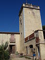
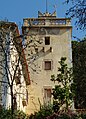
Català: Torre de Can Bonet d'Avall, obra popular del segle XV reformada el segle XIX, al municipi de Santa Susanna (Maresme).
This is a category about a monument listed in the Catalan heritage register of Béns Culturals d'Interès Nacional and the Spanish heritage register of Bienes de Interés Cultural under the reference IPA-9062. |
Media in category "Torre de Can Bonet d'Avall"
The following 6 files are in this category, out of 6 total.
-
 Can Bonet Santa Susanna 2.jpg 3,648 × 2,736; 4.37 MB
-
 Can Bonet Santa Susanna 3.jpg 3,648 × 2,736; 3.84 MB
-
 Can Bonet Santa Susanna.jpg 3,526 × 2,566; 2.94 MB
-
 Torre Can Bonet Santa Susanna 2.jpg 2,736 × 3,648; 3.76 MB
-
 Torre Can Bonet Santa Susanna 3.jpg 2,736 × 3,648; 4.18 MB
-
 Torre Can Bonet Santa Susanna.jpg 2,524 × 3,498; 4.08 MB


