Category:The Crooked House
Jump to navigation
Jump to search
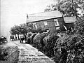
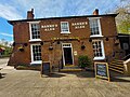
demolished public house in Staffordshire, England .jpg) | |||||
| Upload media | |||||
| Instance of | |||||
|---|---|---|---|---|---|
| Location | Himley, South Staffordshire, Staffordshire, West Midlands, England | ||||
| Street address |
| ||||
| Owned by |
| ||||
| Inception |
| ||||
| Dissolved, abolished or demolished date |
| ||||
| Significant event |
| ||||
| Cause of destruction | |||||
| official website | |||||
 | |||||
Media in category "The Crooked House"
The following 25 files are in this category, out of 25 total.
-
 C V for Joiner - geograph.org.uk - 457062.jpg 480 × 640; 142 KB
-

-
 Crooked House (8061973923).jpg 1,246 × 914; 670 KB
-
Crooked House marble (April 2023).webm 0.0 s; 1.27 MB
-
 Crooked House, Himley. - geograph.org.uk - 53903.jpg 620 × 479; 91 KB
-
 Crooked Pub - geograph.org.uk - 457048.jpg 640 × 480; 112 KB
-
 Crookedhousewindow-2023-04.jpg 2,400 × 3,472; 4.1 MB
-
 Door to The Crooked House - geograph.org.uk - 5852220.jpg 683 × 1,024; 239 KB
-
 Glynne Arms, Himley - geograph.org.uk - 129423.jpg 640 × 427; 127 KB
-
 Glynnearms1904.jpg 1,201 × 900; 191 KB
-

-
 Lane to the Crooked House - geograph.org.uk - 5215607.jpg 800 × 534; 152 KB
-
 The Crooked House - geograph.org.uk - 5215621.jpg 800 × 587; 140 KB
-
 The Crooked House - geograph.org.uk - 5852168.jpg 1,024 × 768; 256 KB
-
 The Crooked House - geograph.org.uk - 5852176.jpg 1,024 × 768; 354 KB
-

-
 The Crooked House Himley - geograph.org.uk - 423091.jpg 640 × 480; 131 KB
-
 The Crooked House PH, near Gornalwood - geograph.org.uk - 6009538.jpg 5,184 × 2,920; 4.82 MB
-
 The Crooked House, Dudley - geograph.org.uk - 96790.jpg 639 × 447; 83 KB
-
 The Crooked House, Himley - geograph.org.uk - 1218550.jpg 640 × 414; 68 KB
-
 The Crooked House, Himley - geograph.org.uk - 3068308.jpg 2,048 × 1,536; 1.05 MB
-
 The Crooked House, near Lower Gornal - geograph.org.uk - 4730749.jpg 1,024 × 768; 173 KB
-
 The Crooked House.jpg 400 × 300; 32 KB
-
 Thecrookedhouse-2023-06.jpg 4,000 × 3,000; 8.35 MB
-
 View out of the door of The Crooked House - geograph.org.uk - 5852224.jpg 683 × 1,024; 159 KB


Categories:
- Subsidences caused by mining
- Built in England in 1765
- Pubs in Staffordshire
- Buildings destroyed by fire in the United Kingdom
- Destroyed in England in 2023
- 2023 fires
- Himley
- Farmhouses in Staffordshire
- Brick houses in Staffordshire
- Brick pubs in Staffordshire
- 2023 arsons
- Arsons in the United Kingdom
- Leaning buildings in the United Kingdom