Category:Thalfang
Jump to navigation
Jump to search
municipality of Germany | |||||
| Upload media | |||||
| Instance of |
| ||||
|---|---|---|---|---|---|
| Location | Bernkastel-Wittlich, Rhineland-Palatinate, Germany | ||||
| Population |
| ||||
| Area |
| ||||
| Elevation above sea level |
| ||||
| official website | |||||
 | |||||
Subcategories
This category has the following 5 subcategories, out of 5 total.
Media in category "Thalfang"
The following 31 files are in this category, out of 31 total.
-
Ferienpark Himmelberg - Thalfang - geo.hlipp.de - 15699.jpg 640 × 480; 90 KB
-
Flagge Thalfang.gif 324 × 216; 4 KB
-
Haus 100 - Kiefernweg - geo.hlipp.de - 15697.jpg 640 × 480; 60 KB
-
Haus in Kiefernweg - geo.hlipp.de - 15695.jpg 640 × 480; 48 KB
-
K110 - Thalfang - geo.hlipp.de - 21638.jpg 640 × 480; 79 KB
-
Kiefernweg - geo.hlipp.de - 15693.jpg 640 × 480; 63 KB
-
Kiefernweg - geo.hlipp.de - 15694.jpg 640 × 480; 54 KB
-
Kiefernweg - geo.hlipp.de - 15696.jpg 640 × 480; 59 KB
-
Kiefernweg - geo.hlipp.de - 15698.jpg 480 × 640; 63 KB
-
L150 bei Thalfang - geo.hlipp.de - 15700.jpg 640 × 463; 52 KB
-
L153 zwischen Thalfang und Dhronecken - geo.hlipp.de - 23885.jpg 640 × 453; 72 KB
-
L153 zwischen Thalfang und Dhronecken - geo.hlipp.de - 23886.jpg 640 × 489; 84 KB
-
L155 bei Gielert - geo.hlipp.de - 15596.jpg 640 × 425; 30 KB
-
Lehrpfad haardtwald thalfang 2018.jpg 5,184 × 3,888; 3.74 MB
-
Norma - Thalfang - geo.hlipp.de - 23878.jpg 640 × 480; 40 KB
-
Parkplatz - Kaufhaus Hammerle - geo.hlipp.de - 21640.jpg 640 × 480; 69 KB
-
Thalfang - Hochwaldwerk - 20100829-01.jpeg 2,134 × 1,496; 651 KB
-
Thalfang im Hunsrück vom Erbeskopf.jpg 3,457 × 1,110; 1.06 MB
-
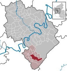
Thalfang in WIL.svg 634 × 666; 402 KB
-
Thalfang, auf der Hauptstraße.jpg 4,272 × 2,848; 2.19 MB
-
Thalfang, das Rathaus.jpg 3,876 × 2,852; 2.6 MB
-
Thalfang, der Landgasthof Rauland.jpg 4,160 × 2,832; 2.27 MB
-
Thalfang, die Hauptstraße.jpg 2,848 × 3,513; 2 MB
-
Thalfang, Haus Bahnhofstraße 13.jpg 4,155 × 2,836; 2.4 MB
-
Thalfang, Haus Saarstraße 3.jpg 4,272 × 2,848; 3.11 MB
-
Thalfang, Hochwald Nahrungsmittel-Werk, Blick zum Erbeskopf.jpg 4,272 × 2,848; 2.54 MB
-
Thalfang, Kirchgasse und evangelische Kirche.jpg 3,907 × 2,819; 2.31 MB
-
Thalfang, Ort im Grünen.jpg 4,272 × 2,848; 2.74 MB
-
Thalfang-Bäsch01.jpg 3,008 × 2,000; 2.89 MB
-
Thalfang-Bäsch02.jpg 3,008 × 2,000; 2.37 MB
-
VR Bank - Thalfang - geo.hlipp.de - 24147.jpg 640 × 480; 48 KB


