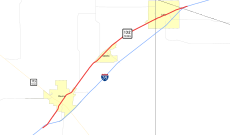
Category:Texas State Highway 132
Jump to navigation
Jump to search
 | number: | (one thirty-two) |
|---|---|---|
| State highways in Texas: | 112 · 113 · 114 · 115 · 116 · 117 · 118 · 119 · 120 · 121 · 122 · 123 · 124 · 125 · 126 · 127 · 128 · 129 · 130 · 131 · 132 · 133 · 134 · 135 · 136 · 137 · 138 · 139 · 140 · 141 · 142 · 143 · 144 · 145 · 146 · 147 · 148 · 149 · 150 · 151 · 152 |
state highway in Medina, Atascosa, and Bexar counties in Texas, United States | |||||
| Upload media | |||||
| Instance of | |||||
|---|---|---|---|---|---|
| Location |
| ||||
| Transport network | |||||
| Connects with | |||||
| Owned by | |||||
| Maintained by | |||||
| Inception |
| ||||
| Length |
| ||||
| Terminus | |||||
| Partially coincident with |
| ||||
| |||||
English: Media related to Texas State Highway 132, a 12.71-mile (20.45 km) state highway in Medina, Atascosa, and Bexar counties in Texas, United States, that connects Interstate 35 (I-35), southwest of Devine, with I-35 (east of Lytle).
Subcategories
This category has only the following subcategory.
Media in category "Texas State Highway 132"
The following 7 files are in this category, out of 7 total.
-
20200824-RD-LSC-0630 (50288255006).jpg 6,669 × 2,255; 9 MB
-
Atascosa County road map.svg 1,180 × 688; 1.17 MB
-
Downtown Lytle, TX IMG 0731.JPG 4,320 × 3,240; 3.41 MB
-
NataliaTexas (1 of 1).jpg 4,874 × 2,144; 5.92 MB
-
Texas 132 1917.svg 1,600 × 1,600; 18 KB
-
Texas 132 map.svg 1,180 × 688; 46 KB
-
Texas 132.svg 384 × 384; 9 KB


