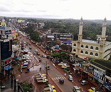
Category:Taliparamba
Jump to navigation
Jump to search
town in Kannur district, Kerala, India | |||||
| Upload media | |||||
| Instance of | |||||
|---|---|---|---|---|---|
| Location | Kannur district, Kerala, India | ||||
| Area |
| ||||
| Elevation above sea level |
| ||||
 | |||||
Taliparamba (also known as Perimchellur, Malayalam: തളിപ്പറമ്പ്) is a municipality in Kannur district in the Indian state of Kerala. It consists of 47 villages which are spread over an area of 1330.56 square kilometres (513.73 square miles). It stretches from the coastal area of Ramanthali to Nuchiyard and Vayathur villages, touching the Karnataka border.12°3′0″N 75°21′0″E / 12.05°N 75.35°E
Subcategories
This category has the following 7 subcategories, out of 7 total.
Media in category "Taliparamba"
The following 5 files are in this category, out of 5 total.
-
Kuppam river.JPG 800 × 600; 167 KB
-
Prof T. P. Muhammad Kunhi.jpg 200 × 200; 4 KB
-
Prof.T.P.Muhammad Kunhi Taliparamba.jpg 183 × 275; 4 KB
-
Traditional Well-Kerala.JPG 1,280 × 960; 152 KB
-
Visitor book Taliparamba.jpg 915 × 1,280; 143 KB


