Category:Tainan MRT maps
Jump to navigation
Jump to search
Media in category "Tainan MRT maps"
The following 33 files are in this category, out of 33 total.
-
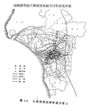
 1990年台南都會區大眾捷運系統規畫路網之替選方案一.png 539 × 648; 46 KB
-
 1990年台南都會區大眾捷運系統規畫路網之替選方案三.png 493 × 588; 56 KB
-
 1990年台南都會區大眾捷運系統規畫路網之替選方案二.png 537 × 675; 49 KB
-
 1990年台南都會區大眾捷運系統規畫路網之替選方案四.png 537 × 626; 51 KB
-
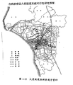
 1990年台南都會區大眾捷運系統規畫路網之長期建議路網.png 547 × 660; 51 KB
-
 2009年台南都會區輕軌運輸系統整體路網.png 508 × 647; 209 KB
-
 Advanced Public Transportation Systems Tainan.png 1,267 × 779; 1.68 MB
-
 Tainan Monorail 1st Phase.svg 512 × 346; 147 KB
-
 Tainan Monorail 2nd Phase.svg 512 × 522; 164 KB
-
 Tainan MRT.jpg 3,356 × 5,584; 699 KB
-
 Tainan MRT.PNG 2,048 × 1,536; 508 KB
-
 Tainan MRT.svg 340 × 560; 97 KB
-
 中華環狀線路線圖2.pdf 4,133 × 885; 110 KB
-
 台南捷運1990年方案一.png 2,048 × 1,536; 240 KB
-
 台南捷運1990年方案三.png 2,048 × 1,536; 282 KB
-
 台南捷運1990年方案二.png 2,048 × 1,536; 283 KB
-
 台南捷運1990年方案四.png 2,048 × 1,536; 329 KB
-
 台南捷運1990年長期方案.png 2,048 × 1,536; 344 KB
-
 台南捷運1999年規劃.png 2,048 × 1,536; 310 KB
-
 台南捷運1999高鐵局規劃.png 2,048 × 1,536; 309 KB
-
 台南捷運綠線路線圖(含主線、延伸線段).svg 2,835 × 567; 734 KB
-
 台南捷運藍線路線圖.png 4,125 × 825; 327 KB
-
 台南捷運路線圖.jpg 3,814 × 8,260; 2.32 MB
-
 台南捷運路線圖.png 3,814 × 8,260; 682 KB
-
 台南捷運路線圖更新.svg 2,551 × 1,417; 2.52 MB
-
 台南捷運路線圖更新作者屬名版.svg 2,551 × 1,417; 2.52 MB
-
 台南輕軌路線圖(主線支線延伸段).svg 3,118 × 1,417; 2.55 MB
-
 府城橫貫線路線圖.pdf 3,541 × 885; 81 KB
-
 府城橫貫線路線圖.svg 2,268 × 567; 155 KB
-
 臺南市區先進公共運輸系統路線圖.svg 2,551 × 1,417; 2.46 MB
-
 臺南市區先進公共運輸系統路線圖2.pdf 2,000 × 1,125; 145 KB
-
 臺南市區先進公共運輸系統路線圖作者屬名版.svg 2,551 × 1,417; 2.47 MB
-
 臺南市捷運路網圖.jpg 608 × 470; 46 KB


