Category:Swiss plateau
Jump to navigation
Jump to search

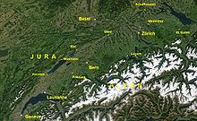
Deutsch: Das Mittelland bildet neben dem Jura und den Alpen eine der drei Grosslandschaften der Schweiz und macht etwa 30 % der schweizerischen Landesfläche aus. Es umfasst das teils flache, weitgehend jedoch hügelige Gebiet der Schweizer Kantone Aargau, Bern, Freiburg, Genf, Luzern, Neuenburg, St. Gallen, Schaffhausen, Schwyz, Solothurn, Thurgau, Waadt, Zug und Zürich zwischen Jura und Alpen. Das Mittelland ist die weitaus am dichtesten besiedelte Region der Schweiz und dadurch auch wirtschaftlich und verkehrstechnisch der bedeutendste Grossraum des Landes. Im Nordwesten und Norden wird das Mittelland geografisch wie auch geologisch durch die langgestreckten Höhenzüge des Jura klar abgegrenzt. Im Süden gegen die Alpen hin ist die Grenze geografisch nicht genau definiert. Meist wird der an einigen Orten relativ abrupte Anstieg zu Höhen über 1500 m ü. M. (Kalkalpen, teilweise auch Berge der subalpinen Molasse) als Kriterium für die Abgrenzung genommen. Die südwestliche Grenze des Schweizer Mittellandes bildet der Genfersee, die nordöstliche Grenze der Bodensee zusammen mit dem .

English: The Swiss plateau (plateau suisse in French, Mittelland in German) constitutes one of the three major landscapes in Switzerland alongside the Jura and the Alps. It covers about 30 % of the Swiss surface. It comprises the regions between the Jura and the Alps, partly flat but mostly hilly, and lays at an average height between 400 and 600 meters AMSL. It is by far the most densely populated region of Switzerland, and the most important with respect to economy and traffic.
Français : Le Plateau suisse (en allemand Schweizer Mittelland) constitue l'un des trois ensembles géographiques de la Suisse aux côtés du Jura et des Alpes. Il couvre environ 30 % de la surface du pays. Il comprend tout l'espace entre le Jura et les Alpes, formé partiellement de plaines, mais principalement de collines, et son altitude moyenne varie entre 400 et 600 m. C'est de loin la région la plus densément peuplée de Suisse, et par conséquent l'espace le plus influent du pays concernant l'économie et les transports.
Italiano: L'Altipiano svizzero (in tedesco Schweizer Mittelland) è una delle tre regioni geografiche della Svizzera. Si trova compreso tra la zona alpina ed il Massiccio del Giura. Copre circa il 30% del paese ed è formato parzialmente da pianure, da laghi, ma principalmente da colline la cui altezza varia tra i 400 ed i 600 m. È la parte della Svizzera maggiormente popolata e di maggior importanza per l'economia e per i trasporti. A nord e a nord-ovest l'altipiano svizzero è nettamente delimitato geograficamente e geologicamente dal massiccio del Giura. A sud non esiste una frontiera precisa con le Alpi.
geographic region | |||||
| Upload media | |||||
| Instance of |
| ||||
|---|---|---|---|---|---|
| Made from material | |||||
| Location | |||||
| Width |
| ||||
| Length |
| ||||
 | |||||
Subcategories
This category has the following 12 subcategories, out of 12 total.
C
Media in category "Swiss plateau"
The following 26 files are in this category, out of 26 total.
-
-i---i- (33923693745).jpg 4,032 × 3,024; 2.25 MB
-
2011-11-17 13-19-44 Germany Baden-Württemberg Immeneich.jpg 4,049 × 2,689; 3.32 MB
-
2011-11-17 13-20-57 Germany Baden-Württemberg Schweikhof.jpg 4,288 × 2,732; 3.62 MB
-
2015, Switzerland (19901964128).jpg 3,648 × 2,736; 2.8 MB
-
20170711 Weissenstein 0567 (36126210693).jpg 5,760 × 3,840; 5.5 MB
-
A plateau suisse on may 2024.jpg 1,210 × 1,613; 247 KB
-
Cloud Blanket between Davos and Zurich (12137106775).jpg 2,703 × 1,794; 1.04 MB
-
Geografische Räume der Schweiz.jpg 7,474 × 1,143; 921 KB
-
Kammersrohr Blick auf Alpen Mai 2011.jpg 2,640 × 1,760; 2.93 MB
-
Kammersrohr Hof Alpenblick.jpg 2,640 × 1,760; 2.78 MB
-
Luzern pilatus.jpg 590 × 400; 90 KB
-
Mittelland He.jpg 1,254 × 774; 343 KB
-
Mittelland vom Stockhorn.jpg 4,000 × 3,000; 4.61 MB
-
Mittelland.JPG 1,249 × 768; 203 KB
-
Nebelmeer Mittelland.jpg 590 × 399; 47 KB
-
Picswiss AG-23-05.jpg 500 × 333; 47 KB
-
Picswiss BE-92-04 Lüderenalp (Kurhaus Hotel).jpg 500 × 333; 42 KB
-
Plateau suisse depuis la Corbetta.jpg 5,932 × 2,234; 8.76 MB
-
Plateau suisse et Alpes depuis la Dent de Vaulion.jpg 4,989 × 1,190; 3.63 MB
-
Room with a view (19979375385).jpg 3,648 × 2,432; 1.97 MB
-
Swiss Plateau.jpg 2,688 × 1,520; 1.02 MB
-
Taubenloch et plateau suisse.jpg 3,264 × 2,448; 767 KB
-
Vue aérienne du Pays des Trois-Lacs.jpg 960 × 640; 92 KB
-
Zentralbibliothek Solothurn Ernst Klöti 0003.jpg 6,415 × 4,184; 21.95 MB
-
Zentralbibliothek Solothurn Ernst Klöti 0147.jpg 4,184 × 6,400; 17.6 MB
-
Zentralbibliothek Solothurn Ernst Klöti 0198.jpg 6,421 × 4,074; 6.06 MB


