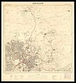
Category:Survey of Palestine 1945-46 map of Jerusalem 1-10,000
Jump to navigation
Jump to search
Media in category "Survey of Palestine 1945-46 map of Jerusalem 1-10,000"
The following 9 files are in this category, out of 9 total.
-
Jerusalem-Compiled, drawn and printed by the Survey of Palestine-1.jpg 2,365 × 2,575; 1.33 MB
-
Jerusalem-Compiled, drawn and printed by the Survey of Palestine-2.jpg 2,188 × 2,406; 1.23 MB
-
Jerusalem-Compiled, drawn and printed by the Survey of Palestine-3.jpg 2,288 × 2,805; 1.36 MB
-
Jerusalem-Compiled, drawn and printed by the Survey of Palestine-4.jpg 2,269 × 2,765; 1.31 MB
-
Jerusalem-Compiled, drawn and printed by the Survey of Palestine-5.jpg 2,249 × 2,426; 1.28 MB
-
Jerusalem-Compiled, drawn and printed by the Survey of Palestine-6.jpg 2,224 × 2,428; 1.07 MB
-
Maliha village boundaries.jpg 1,604 × 1,570; 934 KB


