Category:Strabons world map
Jump to navigation
Jump to search
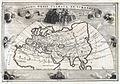
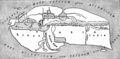
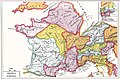
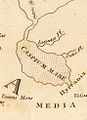
English: Note: These maps are reconstructions based on the textual evidence of Strabo's knowledge, as no original has survived.
Media in category "Strabons world map"
The following 40 files are in this category, out of 40 total.
-

-
-
 Systemes Geographiques de Ptolemee, de Strabon, & d'Eratosthene.jpg 7,349 × 5,098; 4.77 MB
-
 Systemes Geographique de Ptolemee, de Strabon, et d'Eratosthene.jpg 1,600 × 1,185; 336 KB
-
 C+B-Geography-Map1-StrabosMap.PNG 1,566 × 770; 695 KB
-
 Intro karte strabo g.jpg 450 × 300; 58 KB
-
 Map of Europe according to Strabo.jpg 485 × 385; 152 KB
-
 Maps after Strabo 01.jpg 2,557 × 1,708; 5.63 MB
-
 Maps after Strabo 02.jpg 1,115 × 889; 1.48 MB
-
 Maps after Strabo 03.jpg 1,743 × 2,616; 4.66 MB
-
 Maps after Strabo 04.jpg 2,692 × 1,764; 5.17 MB
-
 Maps after Strabo 05.jpg 2,673 × 1,751; 5.14 MB
-
 Maps after Strabo 06.jpg 2,669 × 1,779; 4.06 MB
-
 Maps after Strabo 07.jpg 1,715 × 2,656; 4.76 MB
-
 Maps after Strabo 08.jpg 2,150 × 2,626; 6.37 MB
-
 Maps after Strabo 09.jpg 2,682 × 1,792; 5.96 MB
-
 Maps after Strabo 10.jpg 3,468 × 2,496; 8.62 MB
-
 Maps after Strabo 11.jpg 2,712 × 1,788; 4.5 MB
-
 Maps after Strabo 12.jpg 2,673 × 1,833; 6 MB
-
 Maps after Strabo 13.jpg 2,781 × 1,841; 4.26 MB
-
 Maps after Strabo 14.jpg 1,685 × 2,654; 4.76 MB
-
 Maps after Strabo 15.jpg 2,311 × 2,653; 7.53 MB
-
 Maps after Strabo 17.jpg 3,468 × 2,504; 9.88 MB
-
 Playfair, Principal. Map of the World According to Strabo. 1814 A.jpg 7,523 × 4,724; 4.33 MB
-
 Playfair, Principal. Map of the World According to Strabo. 1814 B.jpg 7,071 × 4,328; 4.1 MB
-
 Playfair, Principal. Map of the World According to Strabo. 1814 C.jpg 2,743 × 2,391; 1.01 MB
-
 Playfair, Principal. Map of the World According to Strabo. 1814 CA.jpg 1,302 × 1,103; 251 KB
-
 Playfair, Principal. Map of the World According to Strabo. 1814 CB.jpg 960 × 765; 142 KB
-
 Playfair, Principal. Map of the World According to Strabo. 1814 CC.jpg 708 × 977; 111 KB
-
 Playfair, Principal. Map of the World According to Strabo. 1814 D.jpg 2,333 × 2,096; 634 KB
-
 Playfair, Principal. Map of the World According to Strabo. 1814.jpg 8,730 × 6,463; 6.99 MB
-
 Strabo-worldmap-Loeb-1917-frontispiece.png 1,037 × 548; 494 KB
-
 STRABON.png 680 × 476; 257 KB
-

-

-

-

-

-

-
 World map Strabo.jpg 3,014 × 1,646; 1.49 MB
.jpg)


_accommodatam,_(3e_%C3%A9d.),_(1er_%C3%A9tat)_-_Sic_delineare_conatus_est_d%27Anville,_Geogr_Regis_primarius,_Regiae_Humaniorum..._-_btv1b8469978k.jpg)
_accommodatam,_(3e_%C3%A9d.),_(2e_%C3%A9tat)_-_sic_delineare_conatus_est_d%27Anville,_Geogr._Regis_primarius,_Regiae_Humaniorum..._-_btv1b84902875.jpg)
_accommodatam,_-_Sic_delineare_conatus_est_d%27Anville_Regiae_Humaniorum_Litterarum_Academiae_socius_-_btv1b53008985x.jpg)


_De_la_Haye_-_btv1b5963497x.jpg)
