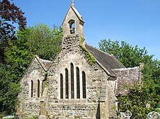
Category:Stoke Wake
Jump to navigation
Jump to search
village in the United Kingdom | |||||
| Upload media | |||||
| Instance of | |||||
|---|---|---|---|---|---|
| Location | Dorset, South West England, England | ||||
| Population |
| ||||
 | |||||
Media in category "Stoke Wake"
The following 45 files are in this category, out of 45 total.
-
A minor road on Bulbarrow Hill - geograph.org.uk - 6062147.jpg 3,776 × 2,520; 3.18 MB
-
All Saints, Stoke Wake- church porch - geograph.org.uk - 1876189.jpg 480 × 640; 170 KB
-
All Saints, Stoke Wake- churchyard (1) - geograph.org.uk - 1876167.jpg 480 × 640; 167 KB
-
All Saints, Stoke Wake- churchyard (2) - geograph.org.uk - 1876171.jpg 480 × 640; 142 KB
-
All Saints, Stoke Wake- churchyard (3) - geograph.org.uk - 1876179.jpg 640 × 480; 164 KB
-
All Saints, Stoke Wake- churchyard (4) - geograph.org.uk - 1876185.jpg 640 × 480; 123 KB
-
All Saints, Stoke Wake- churchyard (5) - geograph.org.uk - 1876188.jpg 640 × 480; 123 KB
-
All Saints, Stoke Wake.JPG 3,264 × 2,448; 2.83 MB
-
Bulbarrow Hill - geograph.org.uk - 2153741.jpg 640 × 480; 47 KB
-
Bulbarrow Hill - geograph.org.uk - 2153855.jpg 640 × 439; 110 KB
-
Bulbarrow Hill - geograph.org.uk - 6241294.jpg 1,024 × 683; 187 KB
-
Bulbarrow Hill Rawlsbury Camp - geograph.org.uk - 2153790.jpg 640 × 427; 67 KB
-
Bulbarrow Hill, the view we should have had - geograph.org.uk - 6062165.jpg 3,776 × 2,520; 3.9 MB
-
Cross at Rawlsbury Camp, Bulbarrow Hill - geograph.org.uk - 6062133.jpg 3,776 × 2,520; 3.1 MB
-
Field beside Bullocks Lane - geograph.org.uk - 6239916.jpg 1,024 × 683; 257 KB
-
Hazelbury Bryan, soggy tyre marks - geograph.org.uk - 1133706.jpg 640 × 474; 76 KB
-
Hazelbury Bryan, tree and rainbow - geograph.org.uk - 1133701.jpg 640 × 480; 34 KB
-
Maize Stubble - geograph.org.uk - 1530735.jpg 640 × 453; 100 KB
-
Mappowder Ford - geograph.org.uk - 4548589.jpg 1,084 × 725; 444 KB
-
Marshwood Vale - geograph.org.uk - 2153841.jpg 640 × 480; 107 KB
-
Old Buildings, Stoke Wake - geograph.org.uk - 3287119.jpg 640 × 480; 86 KB
-
Rawlsbury Camp from the east - geograph.org.uk - 4532392.jpg 640 × 480; 62 KB
-
Sheep grazing, Rawlsbury Camp - geograph.org.uk - 4532400.jpg 640 × 480; 63 KB
-
Skinners Farm - geograph.org.uk - 1530788.jpg 640 × 480; 55 KB
-
Stoke Lane, towards Mappowder - geograph.org.uk - 6240081.jpg 1,024 × 683; 255 KB
-
Stoke Wake Church and churchyard - geograph.org.uk - 4532413.jpg 640 × 480; 86 KB
-
Stoke Wake, driveway to Manor Farm - geograph.org.uk - 3794220.jpg 480 × 640; 109 KB
-
Stoke Wake, finger-post - geograph.org.uk - 1133676.jpg 640 × 480; 54 KB
-
Stoke Wake, postbox No. DT11 155 - geograph.org.uk - 1133674.jpg 480 × 640; 122 KB
-
Trees at All Saints, Stoke Wake - geograph.org.uk - 1876193.jpg 480 × 640; 150 KB
-
View over Balmers Coombe Bottom - geograph.org.uk - 6241291.jpg 1,024 × 683; 205 KB
-
View towards Stoke Wake from Ridouts Farm - geograph.org.uk - 6239915.jpg 1,024 × 683; 193 KB
-
Wessex Ridgeway on Bulbarrow Hill - geograph.org.uk - 6058323.jpg 5,184 × 3,456; 5.81 MB
-
Equestrian Sculpture Stoke Wake - geograph.org.uk - 367810.jpg 640 × 480; 168 KB
-
Signpost - geograph.org.uk - 387113.jpg 640 × 427; 109 KB
-
Stoke Wake to Bulbarrow Hill - geograph.org.uk - 387102.jpg 640 × 427; 162 KB
-
The Old Rectory Stoke Wake - geograph.org.uk - 367801.jpg 640 × 480; 185 KB
-
Woodland in spring - geograph.org.uk - 454747.jpg 640 × 480; 203 KB


