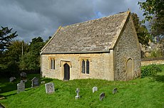
Category:St Faith's chapel, Farmcote
Jump to navigation
Jump to search
| Object location | | View all coordinates using: OpenStreetMap |
|---|
church in Farmcote, Gloucestershire, England, UK | |||||
| Upload media | |||||
| Instance of | |||||
|---|---|---|---|---|---|
| Dedicated to | |||||
| Location | Farmcote, Temple Guiting, Cotswold, Gloucestershire, South West England, England | ||||
| Architectural style | |||||
| Diocese | |||||
| Heritage designation |
| ||||
| Inception |
| ||||
| Religion or worldview | |||||
 | |||||
Media in category "St Faith's chapel, Farmcote"
The following 10 files are in this category, out of 10 total.
-
Farmcote Church - geograph.org.uk - 640412.jpg 640 × 426; 100 KB
-
Interior of Farmcote church - geograph.org.uk - 642485.jpg 426 × 640; 54 KB
-
St Faith's church (1) - geograph.org.uk - 2488031.jpg 4,288 × 3,216; 2.62 MB
-
St Faith's church (2) - geograph.org.uk - 2488034.jpg 4,288 × 3,216; 2.97 MB
-
St Faith's Church graveyard, Farmcote - geograph.org.uk - 2963257.jpg 5,184 × 3,456; 3.61 MB
-
St Faith's church, Farmcote (detail) - geograph.org.uk - 3939570.jpg 640 × 427; 419 KB
-
St Faith's church, Farmcote - geograph.org.uk - 3939567.jpg 640 × 427; 402 KB
-
St Faith's, Farmcote.JPG 2,464 × 1,632; 2.17 MB


