Category:Spanish and Mexican Land Grants in the United States
Jump to navigation
Jump to search
ranch created by land grant by Spain and Mexico in the 18th and 19th centuries in California and Baja California | |||||
| Upload media | |||||
| Subclass of | |||||
|---|---|---|---|---|---|
| Location |
| ||||
| |||||
English: Land grants — of the Spanish colonial New Spain (1769-1821) and post-independence Mexico (1821-1846).
- Formerly located in areas of present day California, and the Southwestern United States.
- For more information, see the Wikipedia articles Ranchos of California and List of Ranchos of California.
Subcategories
This category has the following 13 subcategories, out of 13 total.
A
C
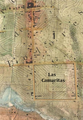
- Rancho Camulos (54 F)
- Centinela Adobe (10 F)
E
G
P
- Rancho Petaluma Adobe (53 F)
R
- Rios-Caledonia Adobe (22 F)
- Rómulo Pico Adobe (11 F)
S
- Rancho Sespe (28 F)
- Rancho Simi (3 F)
Y
- Yorba Hacienda (2 F)
Media in category "Spanish and Mexican Land Grants in the United States"
The following 12 files are in this category, out of 12 total.
-
-
 BacaView.jpg 1,632 × 1,088; 510 KB
-
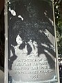 Plaque about Rancho San Jose de Buenos Ayres in Holmby Park, Los Angeles, CA.JPG 3,240 × 4,320; 4.67 MB
-
 Casa de los Cerritos, 4600 American Avenue, Long Beach (Los Angeles County, California).jpg 4,363 × 2,618; 2.24 MB
-

-

-

-
-
 Nell's topographical map of the State of Colorado - DPLA - 85d3ef6e49f097898024f51da220cd9c.jpg 8,999 × 7,035; 14.44 MB
-
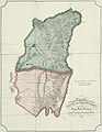
 Rancho San Geronimo (Cacho) - Revere Contract.jpg 608 × 643; 126 KB
-
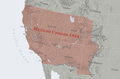 Mexican Cession.png 2,328 × 1,541; 2.81 MB
-
 Opuntia species.jpg 3,264 × 2,448; 1.49 MB


.jpg)


_-_Revere_Contract.jpg)

