Category:Soil shrink swell maps of Gironde
Jump to navigation
Jump to search
Departments of Metropolitan France: Ariège [09] · Aude [11] · Charente [16] · Charente-Maritime [17] · Cher [18] · Corrèze [19] · Creuse [23] · Dordogne [24] · Eure-et-Loir [28] · Gard [30] · Haute-Garonne [31] · Gers [32] · Gironde [33] · Hérault [34] · Indre [36] · Indre-et-Loire [37] · Landes [40] · Loiret [45] · Lot [46] · Lot-et-Garonne [47] · Lozère [48] · Pyrénées-Atlantiques [64] · Hautes-Pyrénées [65] · Pyrénées-Orientales [66] · Deux-Sèvres [79] · Tarn [81] · Tarn-et-Garonne [82] · Vienne [86] · Haute-Vienne [87]
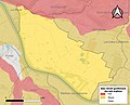
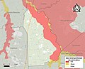
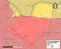
Media in category "Soil shrink swell maps of Gironde"
The following 16 files are in this category, out of 16 total.
-
 33009-Arcachon-argile.jpg 3,057 × 2,480; 1.05 MB
-
 33011-Arès-argile.jpg 3,057 × 2,480; 857 KB
-
 33016-Asques-argile.jpg 3,057 × 2,480; 485 KB
-
 33033-Baurech-argile.jpg 3,057 × 2,480; 588 KB
-
 33038-Bégadan-argile.jpg 3,057 × 2,480; 699 KB
-
 33063-Bordeaux-argile.jpg 3,057 × 2,480; 1.02 MB
-
 33066-Bourdelles-argile.jpg 3,057 × 2,480; 489 KB
-
 33067-Bourg-argile.jpg 3,057 × 2,480; 567 KB
-
 33073-Braud-et-Saint-Louis-argile.jpg 3,057 × 2,480; 679 KB
-
 33075-Bruges-argile.jpg 3,057 × 2,480; 828 KB
-
 33084-Cambes-argile.jpg 3,057 × 2,480; 553 KB
-
 33155-Escaudes-argile.jpg 3,057 × 2,480; 589 KB
-
 33165-Fargues-Saint-Hilaire-argile.jpg 3,057 × 2,480; 548 KB
-
 33236-Lège-Cap-Ferret-argile.jpg 3,057 × 2,480; 1.14 MB
-
 33421-Saint-Jean-de-Blaignac-argile.jpg 3,057 × 2,480; 448 KB
-
 33460-Saint-Pey-de-Castets-argile.jpg 3,057 × 2,480; 570 KB


