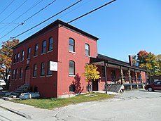
Category:Socialist Labor Party Hall
Jump to navigation
Jump to search
Main Wikipedia article: Socialist Labor Party Hall.
| Object location | | View all coordinates using: OpenStreetMap |
|---|
|
This is a category about a place or building that is listed on the National Register of Historic Places in the United States of America. Its reference number is 98001267. |
historical building in Barre, Vermont | |||||
| Upload media | |||||
| Instance of | |||||
|---|---|---|---|---|---|
| Named after | |||||
| Location | Barre, Washington County, Vermont | ||||
| Street address |
| ||||
| Heritage designation |
| ||||
| Inception |
| ||||
| official website | |||||
 | |||||
Media in category "Socialist Labor Party Hall"
The following 8 files are in this category, out of 8 total.
-
Front door of The Socialist Labor Party Hall.jpg 2,320 × 4,128; 1.43 MB
-
Front of The Socialist Labor Party Hall.jpg 4,128 × 2,322; 3.45 MB
-
National Historic Landmark Plaque.jpg 2,261 × 1,906; 996 KB
-
Socialist Labor Party Hall plaque.jpg 2,046 × 2,215; 1.26 MB
-
Socialist Labor Party Hall, Barre Vermont.jpg 3,600 × 2,527; 2.85 MB
-
Socialist Labor Party Hall, Barre VT.jpg 3,264 × 2,448; 1.95 MB
-
Socialist Labor Party Hall, facade.jpg 3,600 × 2,400; 2.84 MB
-
Street sign for The Socialist Party Labor Hall.jpg 2,322 × 4,128; 2.82 MB
Categories:
- 1900 establishments in the United States
- Buildings on the National Register of Historic Places in Vermont
- Headquarters of political parties
- Italian diaspora in Vermont
- National Historic Landmarks in Vermont
- National Register of Historic Places in Washington County, Vermont
- Socialist Labor Party of America
- Buildings in Barre, Vermont
- Trade union buildings in the United States
- Labor in Vermont


