Category:Snake River
Jump to navigation
Jump to search
major tributary of the Columbia River in the northwestern United States   | |||||
| Upload media | |||||
| Instance of | |||||
|---|---|---|---|---|---|
| Location |
| ||||
| Has part(s) | |||||
| Length |
| ||||
| Origin of the watercourse | |||||
| Mouth of the watercourse | |||||
| Drainage basin | |||||
| Basin country | |||||
| Tributary |
| ||||
 | |||||
Subcategories
This category has the following 16 subcategories, out of 16 total.
B
C
D
F
I
M
- Maps of the Snake River (10 F)
- Meanders of the Snake River (5 F)
R
- Rapids of the Snake River (3 F)
S
T
W
Media in category "Snake River"
The following 93 files are in this category, out of 93 total.
-
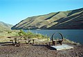 03-25-00, picnic table - panoramio.jpg 2,061 × 1,400; 2.05 MB
-
 03-25-12, snake river - panoramio.jpg 2,048 × 1,403; 1.96 MB
-
 Snake River drainage basin map-fr.svg 808 × 790; 3.92 MB
-
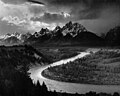 Adams The Tetons and the Snake River.jpg 3,000 × 2,402; 1.78 MB
-
 At Frymier Field - panoramio.jpg 3,488 × 2,616; 3.96 MB
-
 At Mary's Mine - panoramio.jpg 3,488 × 2,616; 3.44 MB
-
 Bonanza - panoramio (2).jpg 3,488 × 2,616; 3.66 MB
-
 Burbank Slough near the Snake R. (8645191036).jpg 2,121 × 1,414; 3.18 MB
-
 Camp on the north fork of Snake River. Fremont County, Idaho. - NARA - 516782.jpg 3,000 × 2,153; 1.46 MB
-
 Wild & scenic Snake River guide, 1997 (IA CAT10847359).pdf 837 × 1,568, 52 pages; 11.99 MB
-
 Snake River activity-operations plan - final (IA CAT91966152).pdf 1,075 × 1,506, 180 pages; 12.03 MB
-
 Confluence of Clearwater and Snake rivers - Lewiston, Idaho (21116852016).jpg 4,850 × 3,212; 3.68 MB
-
 Ecology and management of the South Fork Snake River cottonwood forest (IA ecologymanagemen26meri).pdf 1,281 × 1,662, 108 pages; 27.51 MB
-
 Field in the Lake Channel - panoramio.jpg 3,488 × 2,616; 3.86 MB
-
 Fishing Ramp - panoramio.jpg 3,432 × 2,547; 5.57 MB
-
 KEEPING THE COLUMBIA-SNAKE A WORKING RIVER SYSTEM (IA gov.gpo.fdsys.CHRG-109hhrg21758).pdf 1,275 × 1,650, 89 pages; 2.09 MB
-
-
 Hellscanyon l7 2002262 lrg.jpg 4,000 × 4,000; 4.66 MB
-
 Henry's Fork Looking East - panoramio.jpg 1,600 × 1,200; 394 KB
-
 Hoback en Snake River U.S. Route 89 tussen Alpine en Jackson 8-9-2014 8-52-31.JPG 3,579 × 2,015; 4.25 MB
-
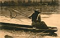 Indian eel fishing on the Snake River (4188889172).jpg 3,138 × 1,995; 781 KB
-

-
 ISS006-E-6639 - View of Oregon.jpg 3,032 × 2,064; 991 KB
-
 Jdrockefeller.jpg 375 × 180; 28 KB
-

-
 Leaning into the Snake River (Yellowstone National Park).jpg 3,648 × 5,472; 5.42 MB
-
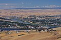
 Lewiston and Clarkston.jpg 2,048 × 1,403; 1.84 MB
-
 Lewiston Banner.jpg 4,850 × 693; 926 KB
-
 Lewiston ID and Clarkston WA city and rivers view 2006.jpg 1,024 × 682; 179 KB
-
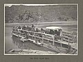
 Lewiston ID waterfront 1905.jpg 1,940 × 1,052; 644 KB
-

-
-

-
-

-
 Milner-dam-id-us.jpg 349 × 232; 47 KB
-
 Minidoka Reservation EO 5375 illustration.png 2,940 × 3,468; 209 KB
-

-
 Neal Moore in 2020.jpg 1,599 × 1,199; 1.08 MB
-
 NPS craters-of-the-moon-regional-map.pdf 370 × 393; 752 KB
-
 Olds' Ferry on Snake River.png 1,270 × 819; 1.04 MB
-
-
 Oxbow Bend outlook in the Grand Teton National Park Edit.jpg 1,732 × 1,231; 1.85 MB
-
 Palouse-River-Mouth.JPG 1,680 × 882; 360 KB
-
 Perrine Bridge BASE Jumpers.jpg 3,000 × 4,000; 3.79 MB
-
 Portneuf Drinks - panoramio.jpg 3,392 × 2,395; 4.87 MB
-

-
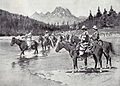 RemingtonBannockIndiansFordingSnake.jpg 3,059 × 2,200; 12 MB
-

-
 Rose Pond Panorama - panoramio.jpg 1,024 × 271; 61 KB
-
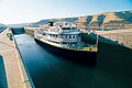 S.S. Legacy transiting locks on Columbia and Snake Rivers.jpg 1,500 × 1,003; 776 KB
-
 SFSnakeRiverID (21582877340).jpg 5,304 × 4,063; 14.36 MB
-
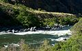 Sheeps Creek rapid on Snake River - panoramio.jpg 1,847 × 1,144; 1.07 MB
-
 Shoshone Falls on the Snake River in Idaho (4153661731).jpg 2,500 × 1,725; 387 KB
-
 Snake river canyon 20070602.JPG 3,888 × 2,592; 2.84 MB
-
 Snake River from Atlantis Arisen.png 3,029 × 1,799; 3.35 MB
-
 Snake River in Hells Caynon.jpg 4,272 × 2,848; 3.6 MB
-
 Snake River Indians by Alfred Jacob Miller, c. 1845-55.JPG 3,245 × 2,010; 732 KB
-
 Snake River Overlook.JPG 2,816 × 2,112; 2.01 MB
-
 Snake River watershed map.png 1,211 × 1,119; 2.1 MB
-
 Snake River, Idaho, USA (17802215525).jpg 3,888 × 2,592; 5.78 MB
-
 Snake River, near Rose Pond - panoramio.jpg 800 × 600; 104 KB
-
 Snake River, Yellowstone National Park, looking towards north 20110818 1.jpg 4,928 × 2,772; 5.86 MB
-
 Snakeriver.jpg 1,280 × 960; 316 KB
-
 Snakeriveridfls.jpg 2,304 × 1,728; 1,023 KB
-
 Snake River resource management plan - final EIS (IA snakeriverresour00pine).pdf 1,345 × 1,758, 300 pages; 76.17 MB
-
 Snake River resource management plan - draft environmental impact statement (IA snakeriverresour00unit).pdf 1,300 × 1,789, 252 pages; 57.39 MB
-
 Snake River resource management plan - final EIS (IA snakeriverresource00unit).pdf 1,341 × 1,772, 298 pages; 74.92 MB
-
 Sunrise silhouette at Ice Harbour Dam on the Snake R. (8644093967).jpg 2,121 × 1,414; 3.22 MB
-
 Tailing Piles from Gold Mining on the Snake River - panoramio.jpg 3,488 × 2,616; 4.04 MB
-
 Teton Range 33.JPG 5,184 × 3,456; 11.49 MB
-
 Teton Range 34.JPG 5,184 × 3,456; 11.49 MB
-
 Teton Range 37.JPG 5,184 × 3,456; 8.76 MB
-
 Teton Range 39.JPG 5,184 × 3,456; 9.82 MB
-
 Teton Range 44.JPG 5,184 × 3,456; 9.71 MB
-

-
 The Portneuf Bottoms - panoramio.jpg 3,488 × 2,616; 5.21 MB
-
 The Tetons (26286463859).jpg 5,695 × 3,667; 4.23 MB
-
 The Tetons from the East, South Fork of Snake River, Wyoming, C.R. Savage, Salt Lake.jpg 2,941 × 2,304; 1.44 MB
-
-
 Tucannon-snake-confluence.JPG 1,805 × 1,354; 446 KB
-
 Twin Falls Dam 1989 a.jpg 2,250 × 1,551; 930 KB
-
 Upper Snake River at Massacre Rocks Scott Hauser USRT Foundation.jpg 4,032 × 3,024; 5.76 MB
-

-
 Views at Grand Teton National Park, Wyoming (0814b200-f289-477f-94c0-5d6e2fa489bd).jpg 3,072 × 2,048; 782 KB
-
 Views at Grand Teton National Park, Wyoming (24029770-4738-47df-8265-9e1d86a09f27).jpg 3,072 × 2,048; 668 KB
-
 Views at Grand Teton National Park, Wyoming (2d77977a-3955-4e49-ae75-e50b039e53d6).jpg 3,072 × 2,048; 683 KB
-
 Views at Grand Teton National Park, Wyoming (7f86fb89-cc47-45d1-8c8f-798cb48f46a2).jpg 3,072 × 2,048; 651 KB
-

-
 Views at Grand Teton National Park, Wyoming (bf832f8c-26f0-46cf-966f-ca7d5959b39b).jpg 2,048 × 3,072; 849 KB
-
 Views at Grand Teton National Park, Wyoming (f07dce63-49b2-4c89-b600-0f9f28b92570).jpg 3,072 × 2,048; 675 KB
-
 Web pdfs srfr chinook.pdf 1,275 × 1,650; 863 KB
-
 Snake River near Taylor's Bridge, by Jackson, William Henry, 1843-1942 cleaned.jpg 1,115 × 1,363; 387 KB


.jpg)
.jpg)


.jpg)


.jpg)


.jpg)
.jpg)


.jpg)

.jpg)
.jpg)
.jpg)


.jpg)


.jpg)


.jpg)

.jpg)


.jpg)


.jpg)


.JPG)

.jpg)


.JPG)
.jpg)
.jpg)
.jpg)
.jpg)
.jpg)
.jpg)
.jpg)

.jpg)
.jpg)