Category:Shalbourne
Jump to navigation
Jump to search
village in Wiltshire, England, UK | |||||
| Upload media | |||||
| Instance of | |||||
|---|---|---|---|---|---|
| Location | Wiltshire, South West England, England | ||||
| Population |
| ||||
 | |||||
English: Shalbourne is a civil parish in the English county of Wiltshire. Besides a village of the same name, the parish includes the widely spaced settlements of Bagshot to the north, and Rivar and Oxenwood to the south. Before 1895, about half of the parish of Shalbourne (including its church) lay in Berkshire.
Nederlands: Shalbourne is een dorp (village) en civil parish in de unitary authority Wiltshire, in het Engelse graafschap Wiltshire. De civil parish telt
Subcategories
This category has the following 5 subcategories, out of 5 total.
Media in category "Shalbourne"
The following 196 files are in this category, out of 196 total.
-
 24 Kingston Road, Shalbourne.jpg 4,000 × 3,000; 4.82 MB
-
 25 Kingston Road, Shalbourne, Wiltshire.jpg 4,000 × 3,000; 4.62 MB
-
 26 Kingston Road, Shalbourne 01.jpg 4,000 × 3,000; 4.64 MB
-
 26 Kingston Road, Shalbourne 02.jpg 4,000 × 3,000; 4.57 MB
-
 28 Kingston Road, Shalbourne.jpg 4,000 × 3,000; 4.9 MB
-
 A338 crossroads atop Carvers Hill - geograph.org.uk - 2987490.jpg 3,562 × 2,342; 1.44 MB
-
 A338 dips downward near Wilton Down - geograph.org.uk - 3392561.jpg 4,320 × 3,240; 4.88 MB
-
 A338 southwest of Marymere Farm - geograph.org.uk - 2987489.jpg 3,479 × 2,595; 1.85 MB
-
 Bank Cottage, Shalbourne - geograph.org.uk - 99713.jpg 640 × 481; 69 KB
-
 Barn at Noon's Farm - geograph.org.uk - 861754.jpg 640 × 480; 91 KB
-
 Barn north of Shalbourne Manor.jpg 4,000 × 3,000; 4.82 MB
-
 Barn north-west of Shalbourne Manor.jpg 4,000 × 3,000; 4.96 MB
-
 Baverstock Farmhouse, Shalbourne.jpg 1,800 × 1,350; 729 KB
-
 Brick and flint cottage - geograph.org.uk - 4711871.jpg 1,050 × 1,050; 1.3 MB
-
 Bridleway near Rivar - geograph.org.uk - 1921313.jpg 640 × 480; 169 KB
-
 Byway above Rivar - geograph.org.uk - 243816.jpg 640 × 478; 125 KB
-
 Byway descending to Shalbourne - geograph.org.uk - 1014743.jpg 640 × 480; 162 KB
-
 Byway near Oxenwood - geograph.org.uk - 1921318.jpg 480 × 640; 179 KB
-
 Byway, Rivar - geograph.org.uk - 1921321.jpg 480 × 640; 228 KB
-
 Carvers Hill exits Shalbourne - geograph.org.uk - 3387481.jpg 3,648 × 2,588; 1.81 MB
-

-

-
 Cottage, Ham - geograph.org.uk - 243566.jpg 640 × 480; 158 KB
-
 Country lane, Shalbourne, Wiltshire - geograph.org.uk - 4777661.jpg 640 × 385; 104 KB
-
 Country lane, Shalbourne, Wiltshire - geograph.org.uk - 4777690.jpg 640 × 469; 56 KB
-
 Crooked Cottage, Shalbourne.jpg 1,800 × 1,350; 1,004 KB
-
 Cruck House, Shalbourne.jpg 4,000 × 3,000; 4.66 MB
-

-
 Downland, Shalbourne - geograph.org.uk - 4440623.jpg 640 × 480; 235 KB
-
 Downs view from a road leading to Fosbury Farm - geograph.org.uk - 4190080.jpg 4,608 × 3,456; 5.88 MB
-
 Evening, Wilton Down and A338 - geograph.org.uk - 3392547.jpg 3,240 × 4,320; 3.43 MB
-

-
 Farm road, Shalbourne - geograph.org.uk - 760991.jpg 640 × 480; 141 KB
-
 Farm Track to Gallowood - geograph.org.uk - 3360040.jpg 3,648 × 2,736; 2.99 MB
-
 Farmland and various woods, near Newtown - geograph.org.uk - 1246689.jpg 640 × 480; 143 KB
-
 Farmland and woodland, Standen - geograph.org.uk - 254533.jpg 640 × 480; 103 KB
-
 Farmland at Newtown, Shalbourne - geograph.org.uk - 243858.jpg 640 × 478; 88 KB
-
 Farmland below Botley Down - geograph.org.uk - 5516809.jpg 640 × 427; 61 KB
-
 Farmland below Rivar Down - geograph.org.uk - 1014749.jpg 640 × 480; 127 KB
-
 Farmland below Rivar Down - geograph.org.uk - 243852.jpg 640 × 398; 107 KB
-
 Farmland beneath downs, Shalbourne - geograph.org.uk - 4440640.jpg 640 × 480; 241 KB
-
 Farmland east of Marten - geograph.org.uk - 983008.jpg 640 × 480; 114 KB
-
 Farmland seen from Rivar Down - geograph.org.uk - 4429080.jpg 800 × 677; 122 KB
-
 Farmland, Shalbourne - geograph.org.uk - 1014739.jpg 640 × 480; 113 KB
-
 Farmland, Shalbourne - geograph.org.uk - 1014741.jpg 640 × 480; 116 KB
-
 Farmland, Shalbourne - geograph.org.uk - 1014745.jpg 640 × 480; 141 KB
-
 Farmland, Shalbourne - geograph.org.uk - 1014746.jpg 640 × 480; 135 KB
-
 Farmland, Shalbourne - geograph.org.uk - 1014747.jpg 640 × 480; 173 KB
-
 Farmland, Shalbourne - geograph.org.uk - 1014748.jpg 640 × 480; 177 KB
-
 Farmland, Shalbourne - geograph.org.uk - 4440603.jpg 640 × 480; 243 KB
-
 Farmland, Shalbourne - geograph.org.uk - 6087649.jpg 1,024 × 768; 299 KB
-
 Farmland, Shalbourne - geograph.org.uk - 6087655.jpg 1,024 × 768; 292 KB
-
 Farmland, Shalbourne - geograph.org.uk - 6087675.jpg 1,024 × 768; 213 KB
-
 Farmland, Shalbourne - geograph.org.uk - 6676932.jpg 1,024 × 683; 246 KB
-

-
 Fly-tip on Botley Down - geograph.org.uk - 861817.jpg 640 × 480; 123 KB
-
 Footpath through pasture, Shalbourne - geograph.org.uk - 6087678.jpg 1,024 × 768; 239 KB
-
 Footpath to Shalbourne... - geograph.org.uk - 99705.jpg 640 × 481; 57 KB
-
 Ham Road junction with Mill Lane - geograph.org.uk - 3387472.jpg 3,648 × 2,736; 2.4 MB
-
 Junction of roads in Oxenwood - geograph.org.uk - 5349617.jpg 4,000 × 3,000; 4.18 MB
-
 Kingston Hall, Shalbourne 02.jpg 4,000 × 3,000; 4.71 MB
-
 Kingston Hall, Shalbourne.jpg 1,800 × 1,350; 745 KB
-
 Littlecourt, Shalbourne.jpg 1,350 × 1,800; 1,022 KB
-
 Long Walk - geograph.org.uk - 4339052.jpg 4,320 × 3,240; 5.49 MB
-
 Marten - Botley Down - geograph.org.uk - 1263205.jpg 640 × 480; 79 KB
-
 Marten - The Road to Great Bedwyn - geograph.org.uk - 1263223.jpg 480 × 640; 122 KB
-
 Marten - The Road To Oxenwood - geograph.org.uk - 1263216.jpg 480 × 640; 117 KB
-
 Marten - Windmill Restaurant - geograph.org.uk - 1447205.jpg 640 × 480; 86 KB
-
 Marten - Windmill Restaurant - geograph.org.uk - 1447219.jpg 640 × 480; 64 KB
-
 Marymere Farm, Shalbourne - geograph.org.uk - 761006.jpg 640 × 480; 113 KB
-
 Marymere Farm, Shalbourne - geograph.org.uk - 763611.jpg 640 × 480; 132 KB
-
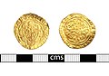 Medieval coin, Quarter noble of Richard II (FindID 815285).jpg 1,284 × 899; 526 KB
-
 Mid Wilts Way at the top of Rivar Hill - geograph.org.uk - 6250088.jpg 1,024 × 683; 270 KB
-
 Nick in Botley Down - geograph.org.uk - 861812.jpg 640 × 317; 53 KB
-
 Northeast from Piccadilly - geograph.org.uk - 1248110.jpg 640 × 480; 133 KB
-
 Oakhill Cottage, Shalbourne - geograph.org.uk - 2523567.jpg 3,412 × 2,499; 1.37 MB
-
 Old bales near Folly Farm, Shalbourne - geograph.org.uk - 763400.jpg 640 × 480; 157 KB
-
 Ordnance Survey Flush Bracket S9338 - geograph.org.uk - 5349638.jpg 4,000 × 3,000; 4.16 MB
-
 Pasture and hedge - geograph.org.uk - 861811.jpg 640 × 480; 85 KB
-
 Pasture, Bagshot, Shalbourne - geograph.org.uk - 4440599.jpg 640 × 480; 222 KB
-
 Pasture, Newtown, Shalbourne - geograph.org.uk - 4440617.jpg 640 × 480; 169 KB
-
 Pasture, Shalbourne - geograph.org.uk - 4440616.jpg 640 × 480; 196 KB
-
 Path through woodland, Shalbourne - geograph.org.uk - 6087669.jpg 1,024 × 768; 364 KB
-
 Piccadilly, Marten - geograph.org.uk - 1248017.jpg 640 × 480; 142 KB
-

-
 Pylons and farmland, Oxenwood - geograph.org.uk - 769388.jpg 640 × 480; 92 KB
-

-
 Ridgeway near Upham - geograph.org.uk - 1015005.jpg 640 × 480; 83 KB
-
 Rivar - geograph.org.uk - 738328.jpg 640 × 480; 131 KB
-
 Rivar Down - geograph.org.uk - 1014753.jpg 640 × 480; 160 KB
-
 Rivar Down - geograph.org.uk - 738310.jpg 640 × 480; 132 KB
-
 Rivar Down - geograph.org.uk - 738315.jpg 640 × 480; 148 KB
-
 Rivar Down - geograph.org.uk - 738317.jpg 640 × 480; 151 KB
-
 Rivar Down - geograph.org.uk - 763645.jpg 640 × 480; 101 KB
-
 Rivar Down from Piccadilly - geograph.org.uk - 1248191.jpg 640 × 480; 148 KB
-
 Rivar Down, east of Marten, Wiltshire - geograph.org.uk - 983048.jpg 640 × 480; 89 KB
-
 Road junction at the top of Rivar Bank - geograph.org.uk - 5349648.jpg 4,000 × 3,000; 4.82 MB
-
 Shalbourne - Burr House - geograph.org.uk - 1450630.jpg 640 × 480; 73 KB
-
 Shalbourne - Cottage - geograph.org.uk - 1450572.jpg 640 × 480; 114 KB
-
 Shalbourne - Cottage - geograph.org.uk - 1450625.jpg 640 × 480; 122 KB
-
 Shalbourne - Field Entrance - geograph.org.uk - 1450619.jpg 640 × 480; 105 KB
-
 Shalbourne - Former Chapel - geograph.org.uk - 1450579.jpg 640 × 480; 109 KB
-
 Shalbourne - Houses - geograph.org.uk - 1450581.jpg 640 × 480; 109 KB
-
 Shalbourne - Path - geograph.org.uk - 1450616.jpg 480 × 640; 143 KB
-

-
 Shalbourne - Post Office And Stores - geograph.org.uk - 1450633.jpg 640 × 480; 77 KB
-
 Shalbourne - Primary School - geograph.org.uk - 1450622.jpg 640 × 480; 92 KB
-
 Shalbourne - Sunday School - geograph.org.uk - 1450578.jpg 640 × 480; 109 KB
-
 Shalbourne - Thatched Cottage - geograph.org.uk - 1450585.jpg 640 × 480; 90 KB
-
 Shalbourne Gliding Club - geograph.org.uk - 4711594.jpg 1,600 × 1,000; 237 KB
-
 Shalbourne Manor - geograph.org.uk - 4259861.jpg 1,024 × 710; 203 KB
-
 Shalbourne Manor 01.jpg 4,000 × 3,000; 4.81 MB
-
 Shalbourne Manor 02.jpg 4,000 × 3,000; 4.82 MB
-
 Shalbourne Manor 03.jpg 4,000 × 3,000; 4.98 MB
-
 Shalbourne Soaring Society - southern end of field - geograph.org.uk - 3360659.jpg 3,648 × 2,736; 2.89 MB
-

-
 Six Acre Lane near Shalbourne - geograph.org.uk - 6210964.jpg 1,920 × 1,280; 1.22 MB
-
 Steep descent into Shalbourne - geograph.org.uk - 3392498.jpg 4,320 × 3,240; 4.88 MB
-
 Stubble on Rivar Down - geograph.org.uk - 1014756.jpg 640 × 480; 144 KB
-
 Stype Wood Stud, Shalbourne - geograph.org.uk - 4440609.jpg 640 × 480; 216 KB
-
 Sunflowers at Shalbourne village, Wiltshire - geograph.org.uk - 4172081.jpg 4,608 × 3,456; 3.69 MB
-
 The A338, Shalbourne - geograph.org.uk - 6210989.jpg 1,848 × 1,162; 1.24 MB
-
 The A338, Shalbourne - geograph.org.uk - 760987.jpg 640 × 480; 136 KB
-
 The entrance to Newtown Farm, Shalbourne - geograph.org.uk - 6212016.jpg 1,920 × 1,280; 1.58 MB
-
 The entrance to Newtown Farm, Shalbourne - geograph.org.uk - 6212018.jpg 1,920 × 1,280; 1.18 MB
-
 The entrance to Tyler Hardwoods, Shalbourne - geograph.org.uk - 6210991.jpg 1,920 × 1,280; 2.17 MB
-
 The entrance to Tyler Hardwoods, Shalbourne - geograph.org.uk - 6210992.jpg 1,920 × 1,280; 1.74 MB
-
 The entrance to Tyler Hardwoods, Shalbourne - geograph.org.uk - 6210995.jpg 1,920 × 1,280; 2.16 MB
-

-
 The Mid Wiltshire Way at Rivar - geograph.org.uk - 4441067.jpg 595 × 800; 214 KB
-
 The Old Post Office, Shalbourne, Wiltshire - geograph.org.uk - 4579777.jpg 5,030 × 3,793; 6.49 MB
-
 The Steppes, Shalbourne.jpg 4,000 × 3,000; 5 MB
-
 Track and farmland, Shalbourne - geograph.org.uk - 763300.jpg 640 × 480; 135 KB
-
 Un-named lane junction east of Rivar Firs - geograph.org.uk - 3360061.jpg 3,648 × 2,736; 2.97 MB
-
 Un-named lane north of Gallowood - geograph.org.uk - 3360055.jpg 3,296 × 2,524; 2.2 MB
-
 Un-named lane passes 21 and 22 Oxenwood - geograph.org.uk - 3360023.jpg 3,648 × 2,736; 2.4 MB
-
 Un-named lane south of Cross Droves - geograph.org.uk - 3359464.jpg 3,648 × 2,736; 2.59 MB
-
 Un-named lane south of high voltage power lines - geograph.org.uk - 3360030.jpg 3,648 × 2,736; 2.44 MB
-
 View from the A338, Shalbourne - geograph.org.uk - 6212020.jpg 1,920 × 1,280; 926 KB
-

-
 Village green, Shalbourne - geograph.org.uk - 4172085.jpg 4,608 × 3,456; 4.39 MB
-
 Village Noticeboard - geograph.org.uk - 4711856.jpg 1,600 × 942; 474 KB
-

-

-

-
 Wood Barn, Shalbourne.jpg 1,800 × 1,350; 639 KB
-
 Woodland, Shalbourne - geograph.org.uk - 4440605.jpg 640 × 480; 308 KB
-
 A closer look at farmland east of Marten - geograph.org.uk - 983026.jpg 640 × 480; 144 KB
-
 Above Shalbourne - geograph.org.uk - 274187.jpg 640 × 480; 85 KB
-
 Above Shalbourne - geograph.org.uk - 274925.jpg 640 × 480; 58 KB
-
 Ashley Down - geograph.org.uk - 243813.jpg 640 × 478; 88 KB
-
 Ashley Down - geograph.org.uk - 763933.jpg 640 × 480; 155 KB
-
 Botley Down - geograph.org.uk - 763677.jpg 640 × 480; 100 KB
-
 Byway above Shalbourne - geograph.org.uk - 274929.jpg 640 × 480; 137 KB
-
 Byway on Rivar Hill - geograph.org.uk - 769135.jpg 640 × 480; 154 KB
-
 Carvers Hill Farm, Shalbourne - geograph.org.uk - 769108.jpg 640 × 480; 135 KB
-
 Downland view, Marten - geograph.org.uk - 738281.jpg 640 × 480; 138 KB
-
 Farmland and plantation, Bagshot - geograph.org.uk - 760984.jpg 640 × 480; 126 KB
-

-
-
 Farmland near Hungerford - geograph.org.uk - 760968.jpg 640 × 480; 144 KB
-
 Farmland near Hungerford - geograph.org.uk - 760986.jpg 640 × 480; 139 KB
-
 Farmland near Hungerford - geograph.org.uk - 763170.jpg 640 × 480; 145 KB
-
 Farmland near Marten - geograph.org.uk - 761009.jpg 640 × 480; 132 KB
-
 Farmland near Shalbourne - geograph.org.uk - 243854.jpg 640 × 405; 93 KB
-
 Farmland, Bagshot - geograph.org.uk - 763252.jpg 640 × 480; 103 KB
-
 Farmland, Great Bedwyn - geograph.org.uk - 761004.jpg 640 × 480; 135 KB
-
 Farmland, Great Bedwyn - geograph.org.uk - 763588.jpg 640 × 480; 132 KB
-
 Farmland, Marten - geograph.org.uk - 738249.jpg 640 × 480; 125 KB
-
 Farmland, Marten - geograph.org.uk - 738307.jpg 640 × 480; 145 KB
-
 Farmland, Newtown, Shalbourne - geograph.org.uk - 763461.jpg 640 × 480; 141 KB
-
 Farmland, Oxenwood - geograph.org.uk - 761011.jpg 640 × 480; 114 KB
-
 Farmland, Oxenwood - geograph.org.uk - 761015.jpg 640 × 480; 122 KB
-
 Farmland, Oxenwood - geograph.org.uk - 763688.jpg 640 × 480; 111 KB
-
 Farmland, Rivar - geograph.org.uk - 738320.jpg 640 × 480; 105 KB
-
 Farmland, Rivar - geograph.org.uk - 738322.jpg 640 × 480; 121 KB
-
 Farmland, Rivar - geograph.org.uk - 738325.jpg 640 × 480; 132 KB
-
 Farmland, Rivar - geograph.org.uk - 738326.jpg 640 × 480; 104 KB
-
 Farmland, Shalbourne - geograph.org.uk - 257615.jpg 640 × 478; 108 KB
-
 Farmland, Shalbourne - geograph.org.uk - 760990.jpg 640 × 480; 152 KB
-
 Farmland, Shalbourne - geograph.org.uk - 761001.jpg 640 × 480; 124 KB
-
 Farmland, Shalbourne - geograph.org.uk - 763565.jpg 640 × 480; 105 KB
-
 Farmland, Shalbourne - geograph.org.uk - 763619.jpg 640 × 480; 120 KB
-
 Farmland, Shalbourne - geograph.org.uk - 769087.jpg 640 × 480; 131 KB
-
 Farmland, Shalbourne - geograph.org.uk - 769090.jpg 640 × 480; 107 KB
-
 Farmland, Shalbourne - geograph.org.uk - 769099.jpg 640 × 480; 96 KB
-
 Field between woods, Shalbourne - geograph.org.uk - 243864.jpg 640 × 478; 89 KB
-
 Looking North East from Ham Road - geograph.org.uk - 101002.jpg 640 × 481; 55 KB
-
 Mount Prosperous - geograph.org.uk - 3136.jpg 640 × 480; 36 KB
-
 Prosperous Home Farm - geograph.org.uk - 100984.jpg 640 × 481; 42 KB
-
 Rivar Farm - geograph.org.uk - 243824.jpg 640 × 478; 116 KB
-
 Shalbourne Heath Plantation - geograph.org.uk - 243866.jpg 640 × 478; 210 KB
-
 Stubble next to Newtown Dairy - geograph.org.uk - 243861.jpg 640 × 421; 90 KB
-
 The A338 - geograph.org.uk - 257618.jpg 640 × 478; 119 KB
-
 The road to Wilton, south of Great Bedwyn - geograph.org.uk - 400010.jpg 640 × 480; 167 KB
-
 The top of Cutting Hill - geograph.org.uk - 100994.jpg 640 × 481; 36 KB


.jpg)


