Category:Severn Beach Line
Jump to navigation
Jump to search
English: The Severn Beach Line is a railway line linking Bristol Temple Meads in Bristol to Severn Beach in South Gloucestershire.
railway line in United Kingdom  | |||||
| Upload media | |||||
| Instance of | |||||
|---|---|---|---|---|---|
| Part of |
| ||||
| Location | City of Bristol, South West England, England | ||||
| Owned by | |||||
| Operator | |||||
| Has part(s) |
| ||||
| Date of official opening |
| ||||
| Terminus | |||||
 | |||||
Subcategories
This category has the following 19 subcategories, out of 19 total.
A
- Avonmouth railway station (66 F)
B
C
D
- Dr Day's Junction (8 F)
L
M
- Montpelier railway station (67 F)
N
- Narroways Hill Junction (32 F)
R
- Redland railway station (71 F)
S
- Shirehampton railway station (33 F)
- St Andrews Road railway station (60 F)
Media in category "Severn Beach Line"
The following 68 files are in this category, out of 68 total.
-
 Severn Beach line.png 1,686 × 1,625; 2.17 MB
-
 Arches SBL.jpg 2,288 × 1,712; 1.23 MB
-
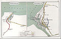
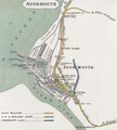 Avonmouth rly map 1914.png 1,407 × 1,560; 3.29 MB
-

-
 Bristol MMB R7 Clifton Down Tunnel.jpg 1,728 × 2,304; 1.83 MB
-
 Bristol MMB R8 Clifton Down Tunnel.jpg 1,728 × 2,304; 1.17 MB
-
 Bristol MMB R9 Clifton Down Tunnel.jpg 2,304 × 1,728; 1.46 MB
-
 Bristol MMB S4 The Downs.jpg 2,304 × 1,728; 1.82 MB
-
 Bristol MMB «37 Portway Park & Ride.jpg 2,400 × 1,600; 1.1 MB
-
 Bristol MMB «88 Cross Country Route.jpg 2,289 × 1,536; 1.08 MB
-
 Bristol MMB «90 Cross Country Route.jpg 2,247 × 1,524; 1.12 MB
-
 Bristol MMB «91 Lawrence Hill Junction.jpg 2,301 × 1,533; 1.4 MB
-
 Bristol MMB «93 Stapleton Road.jpg 2,400 × 1,600; 1.41 MB
-
 Bristol MMB «94 Narroways Junction.jpg 1,982 × 1,457; 1.11 MB
-
 Bristol MMB «A4 Narroways Junction.jpg 2,348 × 1,548; 1.67 MB
-
 Bristol MMB «B4 Severn Beach Line and CWS Flour Mills.jpg 2,400 × 1,600; 2.31 MB
-
 Bristol MMB «B5 Avonmouth Docks 66007.jpg 2,343 × 1,569; 1.6 MB
-
 Bristol MMB «D6 Dr Days Junction.jpg 2,132 × 1,468; 1.11 MB
-
 Bristol MMB «E6 River Trym.jpg 2,585 × 3,896; 4.02 MB
-
 Bristol MMB «E8 Severn Beach Line.jpg 2,624 × 3,936; 4.36 MB
-
 Bristol MMB «F1 Lamplighters Bridge.jpg 3,936 × 2,624; 3.61 MB
-
 Bristol MMB «F2 Lamplighters Bridge.jpg 3,774 × 2,539; 3.65 MB
-
 Bristol MMB «H3 Bristol East Junction 43098.jpg 3,805 × 2,438; 2.56 MB
-
 Bristol MMB «H4 Bristol East Junction 43098.jpg 3,852 × 2,496; 2.56 MB
-
 Bristol MMB «H5 Dr Days Bridge Junction.jpg 3,764 × 2,438; 3 MB
-
 Bristol MMB «I3 Bristol East Junction 43122.jpg 3,651 × 2,328; 2.61 MB
-
 Bristol MMB «I4 Bristol East Junction 43122.jpg 3,681 × 2,277; 2.3 MB
-
 Bristol MMB «I5 Bristol East Junction 43122.jpg 3,795 × 2,367; 2.61 MB
-
 Bristol MMB «I6 Cross Country Route.jpg 3,867 × 2,487; 2.74 MB
-
 Bristol MMB «L8 Cross Country Route.jpg 3,033 × 2,348; 2.5 MB
-
 Bristol MMB «M1 Redland Road.jpg 4,199 × 2,741; 5.54 MB
-
 Bristol MMB «M2 Severn Beach Line.jpg 3,813 × 2,674; 4.1 MB
-
 Bristol MMB «M3 St Andrews Road Signal Box.jpg 3,126 × 2,616; 1.86 MB
-
 Bristol MMB «M4 Avonmouth Docks.jpg 3,881 × 2,498; 3.56 MB
-
 Bristol MMB «M6 Bristol East Junction.jpg 4,119 × 2,367; 3.48 MB
-
 Bristol MMB «M7 Bristol East Junction.jpg 3,927 × 2,256; 3.73 MB
-
 Bristol MMB «M8 Bristol East Junction 43304.jpg 4,056 × 2,394; 3.72 MB
-
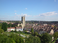 Severn Beach Line View.png 1,600 × 1,200; 2.8 MB
-
 Chittening Siding looking towards Severn Beach.JPG 1,366 × 1,024; 297 KB
-
 Clifton Down railway station MMB 07.jpg 3,726 × 2,578; 3.42 MB
-
 Clifton Down Tracks (snow).jpg 3,648 × 2,736; 2.08 MB
-
 Disused railway - geograph.org.uk - 190828.jpg 480 × 640; 116 KB
-
 Downs air shaft 2.jpg 2,538 × 3,836; 2.6 MB
-
 Downs ventilation shaft (600px).jpg 600 × 951; 75 KB
-
 Hampton Road bridge, Cotham (2024).JPG 1,366 × 910; 743 KB
-
 Lawrence Hill railway station MMB 06.jpg 1,951 × 1,515; 1.09 MB
-
 Montpelier railway bridge Bristol.jpg 2,272 × 1,704; 1.59 MB
-
 NrGorge.jpeg 766 × 1,024; 123 KB
-
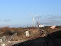
 Portishead Avonmouth RJD 157.jpg 2,729 × 1,769; 993 KB
-
 Portway and SBL.jpg 2,600 × 3,776; 1.5 MB
-
 Railway arch over Gloucester Road - geograph.org.uk - 1165360.jpg 640 × 480; 69 KB
-
 Railway arch over Kingsley Road - geograph.org.uk - 1165368.jpg 480 × 640; 66 KB
-

-

-

-

-
 Railway to Avonmouth - geograph.org.uk - 1249054.jpg 480 × 640; 124 KB
-
 Redland Grove railway bridge.jpg 1,840 × 1,232; 753 KB
-
 River Road and Rail - geograph.org.uk - 959669.jpg 640 × 405; 57 KB
-
 Severn Beach Line map.PNG 604 × 528; 120 KB
-
 Severn beach railway - geograph.org.uk - 190826.jpg 480 × 640; 105 KB
-
 Shirehampton, cut bench mark on railway bridge (geograph 2272280).jpg 480 × 640; 138 KB
-
 Shirehampton, railway bridge (geograph 2272288).jpg 640 × 480; 121 KB
-

-

-
 The Arches - GWR 166204 Bristol bound.JPG 1,366 × 820; 390 KB
-
 Ventilation Shaft - geograph.org.uk - 576598.jpg 480 × 640; 72 KB
-


.jpg)


.jpg)
.JPG)


.jpg)
.jpg)
.jpg)
.jpg)


