Category:Schleuse Altfriesack
Jump to navigation
Jump to search
| Object location | | View all coordinates using: OpenStreetMap |
|---|
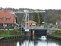
The lock is located at kilometer 29.16 of the Rhin, a right tributary of the river Havel in Brandenburg.  | |||||
| Upload media | |||||
| Instance of | |||||
|---|---|---|---|---|---|
| Location | Wustrau-Altfriesack, Fehrbellin, Ostprignitz-Ruppin District, Brandenburg, Germany | ||||
| Located in or next to body of water | |||||
| Heritage designation | |||||
 | |||||
This is the category of the Brandenburger Baudenkmal (cultural heritage monument) with the ID 09170241 (Wikidata)
|
Deutsch: Die Schleuse Altfriesack, befindet sich bei Kilometer 29,16 des Rhins, einem rechten Nebenfluss der Havel in Brandenburg. Die erste Altfriesacker Schleuse nahm ihren Betrieb im Jahre 1787 auf. Alle schiffbaren Abschnitte des Rhin sind heute Landeswasserstraßen des Bundeslandes Brandenburg in Deutschland. Die Schleuse steht unter Denkmalschutz.
Media in category "Schleuse Altfriesack"
The following 8 files are in this category, out of 8 total.
-
 2008-07-09 Klappbrücke und Schleuse Alt Friesack Wustrau 018.jpg 1,024 × 785; 514 KB
-
 2014-03-02 Schleuse Altfriesack 188.jpg 1,024 × 769; 377 KB
-
 2016-01-22 Klappbrücke Altfriesack 035.jpg 1,024 × 768; 680 KB
-
 2016-01-22 Schleuse Altfriesack 031.jpg 1,024 × 768; 652 KB
-
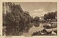 Altfriesack, Brandenburg - Schleusenpartie (Zeno Ansichtskarten).jpg 2,223 × 1,420; 378 KB
-
 Buetzrhin-Klappbruecke-Ruppiner-Wasserstrasse-15-XI-2007-2.jpg 1,024 × 768; 397 KB
-
 Buetzrhin-Schleuse-Ruppiner-Wasserstrasse-15-XI-2007-054.jpg 1,024 × 768; 494 KB
-
 Rhinschleuse Altfriesack b.jpg 3,264 × 2,448; 3.8 MB


.jpg)


