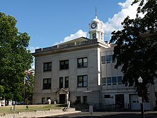
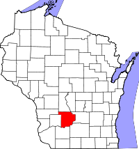
Category:Sauk County, Wisconsin
Jump to navigation
Jump to search
Counties of Wisconsin: Adams · Ashland · Barron · Bayfield · Brown · Buffalo · Burnett · Calumet · Chippewa · Clark · Columbia · Crawford · Dane · Dodge · Door · Douglas · Dunn · Eau Claire · Florence · Fond du Lac · Forest · Grant · Green · Green Lake · Iowa · Iron · Jackson · Jefferson · Juneau · Kenosha · Kewaunee · La Crosse · Lafayette · Langlade · Lincoln · Manitowoc · Marathon · Marinette · Marquette · Menominee · Milwaukee · Monroe · Oconto · Oneida · Outagamie · Ozaukee · Pepin · Pierce · Polk · Portage · Price · Racine · Richland · Rock · Rusk · Sauk · Sawyer · Shawano · Sheboygan · St. Croix · Taylor · Trempealeau · Vernon · Vilas · Walworth · Washburn · Washington · Waukesha · Waupaca · Waushara · Winnebago · Wood
county in Wisconsin, United States | |||||
| Upload media | |||||
| Instance of | |||||
|---|---|---|---|---|---|
| Named after | |||||
| Location | Wisconsin | ||||
| Capital | |||||
| Inception |
| ||||
| Population |
| ||||
| Area |
| ||||
| official website | |||||
 | |||||
English: Media related to Sauk County, Wisconsin, a county in Wisconsin, United States.
Subcategories
This category has the following 12 subcategories, out of 12 total.
Media in category "Sauk County, Wisconsin"
The following 103 files are in this category, out of 103 total.
-
10 of 'The History of Sauk County Wisconsin ... Illustrated' (11189408275).jpg 2,108 × 2,378; 1.44 MB
-
Aldi - panoramio (1).jpg 4,861 × 2,811; 4.13 MB
-
ATC Power Line - panoramio (156).jpg 4,896 × 3,672; 5.72 MB
-
ATC Power Line - panoramio (158).jpg 4,896 × 3,672; 6.21 MB
-
ATC Power Line - panoramio (84).jpg 4,000 × 3,000; 2.38 MB
-
Baraboo downtown.jpg 6,445 × 2,989; 15.27 MB
-
Baraboo High School-2.jpg 4,314 × 2,998; 8.96 MB
-
Baraboo High School.jpg 3,901 × 754; 2.17 MB
-
Baraboo River.jpg 4,000 × 4,218; 12.82 MB
-
Baraboo Town Hall.jpg 3,838 × 1,807; 1.69 MB
-
Bear Creek Town Hall.jpg 4,032 × 1,120; 1.08 MB
-
Watershed work plan, Plain-Honey Creek watershed, Sauk County, Wisconsin (IA CAT91961349).pdf 1,258 × 1,637, 134 pages; 5.38 MB
-
County Trunk Highway DL - panoramio (1).jpg 4,859 × 3,232; 4.99 MB
-
County Trunk Highway DL - panoramio (2).jpg 5,184 × 3,888; 6.2 MB
-
County Trunk Highway DL - panoramio.jpg 4,896 × 3,672; 6.44 MB
-
County Trunk Highway PF - panoramio.jpg 4,821 × 2,786; 7.58 MB
-
County Turnk Highway PF - panoramio (1).jpg 4,896 × 3,672; 6.64 MB
-
County Turnk Highway PF - panoramio (2).jpg 4,868 × 3,110; 6.67 MB
-
County Turnk Highway PF - panoramio (3).jpg 4,896 × 3,672; 9.09 MB
-
County Turnk Highway PF - panoramio (4).jpg 4,887 × 3,550; 4.91 MB
-
County Turnk Highway PF - panoramio (5).jpg 4,849 × 2,876; 4.26 MB
-
County Turnk Highway PF - panoramio (6).jpg 4,896 × 3,672; 5.57 MB
-
County Turnk Highway PF - panoramio (7).jpg 4,868 × 3,082; 4.61 MB
-
County Turnk Highway PF - panoramio.jpg 4,896 × 3,672; 6.35 MB
-
County Turnk Highway W - panoramio (1).jpg 4,868 × 3,138; 6 MB
-
County Turnk Highway W - panoramio (2).jpg 4,840 × 3,222; 5.63 MB
-
County Turnk Highway W - panoramio (3).jpg 4,859 × 3,503; 5.99 MB
-
County Turnk Highway W - panoramio.jpg 3,735 × 3,578; 6.3 MB
-
Dellona Town Hall.jpg 2,916 × 1,706; 1.47 MB
-
East Elementary School - panoramio (1).jpg 4,000 × 3,000; 2.39 MB
-
Fairfield Town Hall.jpg 3,640 × 1,952; 1.65 MB
-
Forevertron Bridge.jpg 1,500 × 1,000; 1.58 MB
-
Forevertron Panoramic 2.jpg 2,000 × 950; 1.53 MB
-
Franklin Town Hall.jpg 3,522 × 1,660; 1.39 MB
-
G.A.R. Hall Building - panoramio.jpg 5,184 × 2,920; 4.27 MB
-
Greenfield Town Hall in Sauk County, Wisconsin.jpg 2,207 × 2,217; 1.34 MB
-
Harry Apostle Lunch Room Building - panoramio.jpg 5,184 × 2,920; 4.59 MB
-
Henry C. Hunt House - panoramio.jpg 4,896 × 3,672; 9.36 MB
-
House on the Rock automated instruments.jpg 1,984 × 1,488; 715 KB
-
HouseOnTheRockCarousel-001.jpg 3,072 × 2,304; 1.26 MB
-
HPIM8818 1.JPG 480 × 640; 172 KB
-
Ironton, Wisconsin.jpg 4,000 × 3,000; 8.01 MB
-
Kasiska Tailor Shop Building - panoramio.jpg 5,184 × 2,920; 4.48 MB
-
Maple Hill - panoramio.jpg 4,840 × 3,466; 5.26 MB
-
Maple Hill Orchard (Closed) - panoramio.jpg 4,419 × 2,885; 3.52 MB
-
McFarlanes' Retail ^ Service Center - panoramio.jpg 5,156 × 2,235; 2.9 MB
-
North Freedom Village Hall.jpg 3,609 × 1,361; 1.22 MB
-
Panorama View of Sauk County - panoramio.jpg 3,200 × 560; 810 KB
-
Park and railroad siding, La Rue, Wisconsin.jpg 5,499 × 3,665; 5.47 MB
-
Plain Village Hall.jpg 3,784 × 1,064; 1.3 MB
-
Plain Village Hall?.jpg 3,429 × 2,372; 6.95 MB
-
Plain, Wisconsin.jpg 7,664 × 2,765; 16.95 MB
-
Prairie Du Sac Town Hall.jpg 3,839 × 1,299; 1.61 MB
-
Prairie Du Sac Village Hall.jpg 4,018 × 3,191; 3.77 MB
-
Reedsburg airport.jpg 4,000 × 2,879; 9.36 MB
-
Reedsburg High School.jpg 4,000 × 2,528; 6.8 MB
-
Reedsburg Town Hall.jpg 3,791 × 1,210; 1.52 MB
-
Reedsburg, Wisconsin.jpg 6,824 × 2,792; 14.66 MB
-
Reedsburge City Hall.jpg 4,032 × 1,682; 1.76 MB
-
Sauk City Village Hall.jpg 4,024 × 1,447; 1.45 MB
-
Sauk County Farm Bureau Food Stand - panoramio.jpg 4,896 × 3,672; 4.87 MB
-
Sauk County Government Building - panoramio.jpg 4,896 × 3,672; 6.08 MB
-
Sauk County Wisconsin Sign I90 I94.jpg 1,920 × 1,280; 956 KB
-
Sauk County Wisconsin Sign US12 WIS16.jpg 1,920 × 1,280; 1.08 MB
-
SaukCountyWisconsin.jpg 2,051 × 1,063; 439 KB
-
SaukCountyWisconsinFairgroundsBarabooWIS33.jpg 1,528 × 1,156; 617 KB
-
Shed ^ Market Store - panoramio.jpg 4,896 × 3,672; 5.88 MB
-
Spellman Granite Works - panoramio.jpg 5,184 × 3,888; 7.18 MB
-
Spring Green Town Hall.jpg 4,000 × 2,331; 6.99 MB
-
Spring Green Village Hall.jpg 3,411 × 2,151; 2.03 MB
-
Stafford Funeral - panoramio.jpg 4,896 × 3,672; 6.05 MB
-
Stanley and Hoag Building - panoramio.jpg 2,920 × 5,184; 4.07 MB
-
State Highways 78-113 - panoramio.jpg 4,896 × 3,672; 6.9 MB
-
State Highways 78-133 - panoramio.jpg 4,896 × 3,672; 7.18 MB
-
Steinke Basin - panoramio.jpg 5,184 × 3,888; 3.83 MB
-
Sumpter Town Hall.jpg 3,612 × 1,810; 1.96 MB
-
Toro Baraboo Plant - panoramio.jpg 4,868 × 2,660; 3.51 MB
-
Tourist Park - panoramio (5).jpg 4,896 × 3,672; 8.54 MB
-
Tower Road - panoramio (2).jpg 4,849 × 3,194; 5.48 MB
-
Tower Road - panoramio (3).jpg 4,896 × 3,391; 6.32 MB
-
Tower Road - panoramio.jpg 4,783 × 2,669; 5.07 MB
-
Tower Rock Elementary School - panoramio.jpg 4,896 × 3,672; 6.02 MB
-
Troy Town Hall in Sauk County, Wisconsin.jpg 3,860 × 2,120; 1.62 MB
-
Unknown Flower - 4549564867.jpg 3,872 × 2,592; 3.25 MB
-
Unknown Flower - 4550212038.jpg 3,872 × 2,592; 3.63 MB
-
Unknown Flower - 4550218076.jpg 3,872 × 2,592; 3.39 MB
-
Unknown Purple Flower.jpg 3,872 × 2,592; 2.94 MB
-
US Highway 12 South of Baraboo - panoramio (1).jpg 5,184 × 2,920; 3.54 MB
-
US Highway 12 South of Baraboo - panoramio.jpg 5,184 × 2,920; 4.11 MB
-
USA Sauk County, Wisconsin age pyramid.svg 520 × 600; 7 KB
-
Violent Thunderstorm Over Sauk County - panoramio.jpg 4,608 × 3,456; 5.49 MB
-
Washington Town Hall in Sauk County, Wisconsin.jpg 3,656 × 2,143; 5.38 MB
-
Westfield Town Hall.jpg 3,519 × 1,657; 2.03 MB
-
Winfield Town Hall.jpg 3,162 × 1,958; 2.25 MB
-
Winter At Parfey S Glen Wisconsin (142601317).jpeg 2,048 × 1,365; 1.63 MB
-
Wisconsin River and Round Top Hill - panoramio.jpg 4,000 × 3,000; 3.65 MB
-
Woodland Town Hall.jpg 3,677 × 1,709; 1.05 MB


