Category:Sauherad

From Wikimedia Commons, the free media repository
Jump to navigation Jump to search
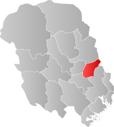
English: Sauherad is a former municipality in the county of Telemark, Norway
Norsk nynorsk: Sauherad var ein kommune i Telemark fylke, Noreg
<nowiki>Sauherad; Sauherad; Sauherad; Сёухерад; Gemeinde; Sauherad; সৌহেরাড; Саухерад; Sauherad; Sauherad; Sauherads kommun; Саугерад; Sauherad; Sauherad; Sauherad; சவ்ஹெராட்; Sauherad; Sauherad; Sauheradi; Sauherad; Sauherad; Sauherad; Sauherad; Sauherad; Sauherad; Sauherad; Sauherad; Sauherad; Sauherad; Sauherad; Sauherad; Sauherad; Sauherad; Sauherad; Sauherad; Sauherad; Sauherad; Sauherad; Sauherad; Sauherad; Sauherad; 賽于赫拉; Sauherad; ساوهاراد; 赛于赫拉; 세우헤라드; municipio de Noruega; commune de Telemark, Norvège; vald; conceyu de Noruega; коммуна в губернии Телемарк (Норвегия); Kommune in der norwegischen Provinz Telemark; comuna da província de Telemark na Noruega; former municipality in Telemark County, Norway; 挪威泰勒马克郡的旧市镇; tidligere kommune i Telemark fylke i Norge; fostă comună în Telemark în Norvegia; tidigare kommun i Telemark i Norge; manisipaa ya Telemark katika Norwei; tidligere kommune i Telemark fylke i Norge; gemeente in Noorwegen; tidlegare kommune i Telemark fylke i Noreg; Norveç'te belediye; komunumo en la provinco Telemark de Norvegio; città norvegese; former municipality in Telemark County, Norway; former municipality in Telemark County, Norway; 位于挪威泰勒马克郡的一个自治区; kommun; conceyu de Sauherad (Noruega); Sauherad kommune</nowiki>
Sauherad 
former municipality in Telemark County, Norway
Upload media
Instance of
LocationTelemark, Norway
Capital
Head of government
  • Mette Haugholt (2015–2019)
Inception
  • 1838
Dissolved, abolished or demolished date
  • 31 December 2019
Significant event
Highest point
  • Vardefjell (814.5 m)
Population
  • 4,338 (2016)
Area
Replaced by
official website
Map59° 26′ 00″ N, 9° 15′ 55″ E
Authority file
Wikidata Q2381
VIAF ID: 130287510
Library of Congress authority ID: n88065765
J9U ID: 987007560265305171
KulturNav-ID: 1087997c-9f5b-4357-9598-4bfc4c8fd2c2
OpenStreetMap relation ID: 405165
Edit infobox data on Wikidata

Subcategories

This category has the following 5 subcategories, out of 5 total.

Media in category "Sauherad"

The following 8 files are in this category, out of 8 total.