Category:Satellite imagery
Jump to navigation
Jump to search
imagery of the Earth or another astronomical object taken from an artificial satellite   | |||||
| Upload media | |||||
| Instance of | |||||
|---|---|---|---|---|---|
| Subclass of |
| ||||
| Start time |
| ||||
| |||||
Subcategories
This category has the following 6 subcategories, out of 6 total.
Media in category "Satellite imagery"
The following 55 files are in this category, out of 55 total.
-
 07U 2024-02-14 0000Z.png 5,993 × 7,809; 16.24 MB
-
 2019 Safir rocket explosion U.S. overhead imagery - NGA declass.pdf 1,650 × 1,275; 209 KB
-
 2022 Pakistan Floods - August 27, 2021 vs. August 27, 2022 in Sindh.jpg 8,830 × 5,792; 8.53 MB
-
 2024-06-02-00 00 2024-06-02-23 59 Sentinel-1 IW VV+VH Custom script(4).jpg 1,920 × 918; 1.83 MB
-
 ADEOS-OCTS.gif 660 × 878; 125 KB
-
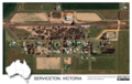 Aerial image of Serviceton, Victoria, Australia, 2020.tif 2,156 × 1,363; 11.21 MB
-
 Aerial view, Kingoonya South Australia, summer 2020 (LocationSA Map Viewer).jpg 1,244 × 1,244; 1.29 MB
-
 AGHON 2024-05-23 0700Z.png 2,950 × 2,909; 6.2 MB
-
 Algae Boom in Lake Erie.jpg 4,211 × 2,935; 9.61 MB
-
 Annotated Zuiderzee area.png 1,436 × 1,438; 4.12 MB
-
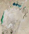 Aral Sea 2024-05-05.png 785 × 922; 1.42 MB
-
 Belagavi Vegetation Index Decline.jpg 2,880 × 2,880; 1.16 MB
-
 Brazilflooding tmo 2023170 lrg (cropped).jpg 772 × 1,044; 625 KB
-
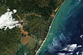 Brazilflooding tmo 2023170 lrg.jpg 2,398 × 1,599; 2.16 MB
-
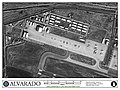 Camp Alvarado 2012.jpg 1,200 × 900; 273 KB
-
-
 Cultivating Egypt’s Desert.jpg 5,514 × 4,032; 8.84 MB
-
 DebrisJourney.gif 513 × 512; 935 KB
-
 Detailed Satellite Imagery of the Idaho Wildfires.png 1,920 × 1,080; 1.41 MB
-
 Dhaka oli 202279 lrg.jpg 1,817 × 1,747; 3.98 MB
-
 Dust Storm Sweeps Across Middle East.jpg 640 × 640; 56 KB
-
 Earth 2017 02 16 (32802878532).jpg 4,169 × 1,760; 1.48 MB
-
 El Niño Disrupts the Marine Food Web.png 720 × 480; 586 KB
-
 EOS Earth Observing System.png 409 × 138; 29 KB
-
 EOS-Data-Analytics-Inc.png 200 × 200; 13 KB
-
 Establishing El Gouna.jpg 750 × 750; 110 KB
-
 Flooding Near Columbia, South Carolina.jpg 720 × 480; 270 KB
-
 Florida After the Storm.jpg 599 × 648; 107 KB
-
 Greenfield, IA EF4 Tornado Satellite Image.jpg 754 × 581; 561 KB
-
 Ground to Space- Joshua Tree National Park.jpg 598 × 696; 167 KB
-
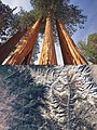 Ground to Space- Sequoia National Park.jpg 720 × 957; 387 KB
-
 Hurricane Harvey Flooding Seen in New NASA Satellite Image.jpg 320 × 652; 105 KB
-
 IceBridge Anniversary.jpg 600 × 400; 47 KB
-
 Kashagan Oil and Gas Field, Kazakhstan.jpg 720 × 960; 139 KB
-
 Linta River Delta and Dunes.jpg 720 × 480; 174 KB
-
 Malaspina Glacier, Alaska.jpg 720 × 480; 161 KB
-
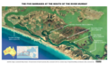
 Map -- Far North region of South Australia.tif 1,206 × 1,559; 7.18 MB
-
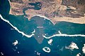
 Map -- location of barrages at the mouth of the River Murray.tif 2,338 × 1,396; 12.45 MB
-
 Map of Steamtown Peterborough Railway Preservation Society sites.jpg 1,434 × 1,437; 621 KB
-
 Mapping Earth Motion from the Illapel Earthquake.png 720 × 480; 300 KB
-
 Mercers lake from NASA ISS067-E-147051.png 1,134 × 723; 1.6 MB
-
 October Puzzler.jpg 720 × 480; 155 KB
-
 OSM North East India.jpg 1,200 × 1,600; 1.04 MB
-
 Precision isn't optional (3224457).jpeg 3,300 × 2,400; 5.98 MB
-
 Pulsating Aurora.jpg 320 × 240; 46 KB
-
 Remotesensing-11-01502-v2.pdf 1,239 × 1,752, 23 pages; 5.23 MB
-
 Roughfire social.jpg 720 × 960; 285 KB
-
 Satellite Image of January 1982 California floods 1745 UTC.png 650 × 712; 873 KB
-
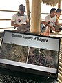
 Satellite imagery of Obudu mountains.png 6,000 × 5,984; 23.52 MB
-
 Satellite imagery resolution diagram.jpg 1,727 × 816; 168 KB
-
 Shaping Cape Cod.jpg 640 × 426; 47 KB
-
 Shrinking Shoreline of the Salton Sea.jpg 720 × 480; 166 KB
-
 Stirling North railway station -- satellite view 2022 (Location SA).jpg 3,971 × 3,221; 9.23 MB
-
 Sunset Thin Blue Line.jpg 1,023 × 681; 8 KB
-
 The London Array.jpg 2,116 × 1,592; 230 KB


.jpg)

.jpg)


.jpg)


.jpg)


.jpeg)


.jpg)

