Category:Sahel
Jump to navigation
Jump to search
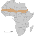
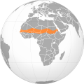
English: The Sahel stretches across the north-central of the African continent between the Atlantic Ocean and the Red Sea.
- It is an African ecoclimatic zone, the transition region between the Sahara Desert in the north and the Sudanian Savannas in the south; and a biogeographic ecoregion in the Tropical and subtropical grasslands, savannas, and shrublands terrestrial biome.
- The Sahel covers parts of the territory (from west to east) of: Senegal, southern Mauritania, Mali, Burkina Faso, southern Algeria, Niger, northern Nigeria, Chad, Sudan (Darfur and southern 'North Sudan'.), northern Ethiopia, and Eritrea.
- Over the history of Africa the region has been home to the Sahelian kingdoms, some of the most advanced kingdoms benefiting from trade across the Sahara desert.
ecoclimatic and biogeographic transition zone in Africa | |||||
| Upload media | |||||
| Instance of | |||||
|---|---|---|---|---|---|
| Part of |
| ||||
| Location | Africa, Southern Hemisphere | ||||
| Different from | |||||
| Said to be the same as | Sudan | ||||
 | |||||
Subcategories
This category has the following 22 subcategories, out of 22 total.
+
B
C
- Savanna in Cameroon (6 F)
G
I
S
- Sahel (Chad) (16 F)
- Securidaca longepedunculata (35 F)
T
- Tiger bush (12 F)
Media in category "Sahel"
The following 140 files are in this category, out of 140 total.
-
Sahara and Sahel.svg 600 × 600; 563 KB
-
Sahara Sahel sub-Saharan Africa.svg 600 × 600; 564 KB
-
Adansonia digitata Bild1139.jpg 2,272 × 1,704; 1.81 MB
-
Africa gis 2015 annual rainfall.png 720 × 815; 446 KB
-
African-American Ancestry Visualized.png 512 × 333; 80 KB
-
African-American Ancestry.png 393 × 512; 77 KB
-
AfricaRain TRM 2007264.jpg 540 × 600; 132 KB
-
AT0713 map.png 1,369 × 561; 41 KB
-
Bamako Kayes road paved 2006.jpg 1,280 × 960; 108 KB
-
Bambara boy in Mali.jpg 2,306 × 1,356; 1.11 MB
-
Bambara girls work.jpg 3,657 × 2,151; 2.36 MB
-
Baobab trees.jpg 928 × 614; 119 KB
-
BaobabElephantBandia.JPG 2,608 × 1,952; 3.83 MB
-
BaobabGriots.jpg 1,628 × 2,198; 501 KB
-
Climate zone.jpg 550 × 297; 41 KB
-
Combat-Antilopes-Bandia-Senegal.jpg 1,600 × 1,200; 998 KB
-
Dogon Country, Bandiagara, Mali, West Africa.jpg 2,000 × 1,053; 1.83 MB
-
Dogon Country, Bandiagara.jpg 2,000 × 1,053; 1.99 MB
-
Falaise de Bandiagara3.jpg 604 × 413; 43 KB
-
Flickr - stringer bel - The road to Timbuktu, Mali (1).jpg 1,722 × 1,146; 434 KB
-
Flickr - stringer bel - The road to Timbuktu, Mali.jpg 1,722 × 1,146; 303 KB
-
Flickr - stringer bel - The road to Timbuktu.jpg 1,722 × 1,146; 270 KB
-
Gapped Bush Niger Nicolas Barbier.jpg 900 × 764; 307 KB
-
Great green wall map.svg 512 × 313; 111 KB
-
Greening Sahel 1982-1999.jpg 949 × 365; 64 KB
-
Grupo de jinetes e infantería.jpg 2,048 × 1,365; 160 KB
-
Harmattan. Dust. Street. Senegal.jpg 864 × 679; 156 KB
-
HDI (Sahel).svg 1,426 × 631; 801 KB
-
Inaya at Melech Ha'olam.jpg 2,964 × 2,223; 6.26 MB
-
ISS008-E-9649 - View of the Sahel.jpg 3,032 × 2,064; 595 KB
-
L'union fait et force.jpg 2,256 × 1,496; 1.37 MB
-
Lake Chad’s shrinking waters ESA418540.gif 2,802 × 2,802; 11.7 MB
-
Landscape Dogon Mali.png 1,024 × 768; 4.01 MB
-
Le marie.jpg 2,256 × 1,496; 1.63 MB
-
Les Falaises de Bandiagara.jpg 1,600 × 1,200; 759 KB
-
Libya Sahel (1998).png 476 × 281; 10 KB
-
Logo UNOWAS.png 363 × 81; 11 KB
-
Maghreb and Sahel - DPLA - d45bfd17f5a3bd99361c261ffbb27f4c.jpg 2,550 × 3,270; 5.67 MB
-
Mali1974-173 hg.jpg 3,813 × 2,550; 1.89 MB
-
Mali1974-174 hg.jpg 2,667 × 3,952; 2.48 MB
-
Mali1974-180 hg.jpg 3,149 × 2,495; 1.46 MB
-
Mali1974-181 hg.jpg 3,974 × 2,641; 2.11 MB
-
Mali1974-182 hg.jpg 3,805 × 2,668; 2.24 MB
-
Map of CILSS.png 1,427 × 628; 29 KB
-
Map of CILSS.svg 1,000 × 1,000; 184 KB
-
Map of the Sahel.png 2,000 × 1,366; 4.12 MB
-
Map sahel 2.png 585 × 600; 81 KB
-
Map sahel 2.svg 1,200 × 1,230; 37 KB
-
Map sahel.jpg 2,000 × 2,050; 272 KB
-
Mapa mali-pt.svg 512 × 366; 16 KB
-
Mapa shonghai-es.svg 512 × 442; 22 KB
-
Mapa shonghai-pt.svg 511 × 441; 20 KB
-
Massimo Barra Niger 1985.jpeg 4,630 × 3,072; 4.97 MB
-
Men carrying straw, Mali.jpg 3,504 × 2,336; 2.99 MB
-
Niger, Guesselbodi (8), view of village.jpg 3,264 × 968; 568 KB
-
Oasis in the Sahel.jpg 720 × 709; 64 KB
-
Operazione Sahel '85. Soccorso in siccità del Niger.jpeg 1,994 × 2,861; 3.54 MB
-
Responding to the COVID-19 Pandemic Amid Multi-layered Crises in the Sahel.webm 1 min 11 s, 1,080 × 1,080; 17.45 MB
-
Rouy -soungouf millet flour porridge basic steps.jpg 504 × 373; 76 KB
-
Sahel Base Map v2.png 954 × 703; 503 KB
-
Sahel Base Map.png 4,227 × 3,136; 641 KB
-
Sahel forest near Kayes Mali.jpg 1,280 × 960; 298 KB
-
Sahel Map-Africa rough.png 2,000 × 925; 291 KB
-
Sahel Map-Africa rough.svg 1,228 × 568; 711 KB
-
Sahel orthographic map.jpg 8,460 × 8,900; 25.27 MB
-
Sahel rain.svg 590 × 197; 988 KB
-
Sahel Rosas do Deserto.png 12,240 × 12,240; 1.32 MB
-
Sahel seasonality iotd.jpg 396 × 211; 45 KB
-
Sahel tunez.svg 512 × 1,113; 56 KB
-
Sahel.svg 600 × 600; 561 KB
-
Savane-boundiali-edit.jpg 1,740 × 1,175; 1.08 MB
-
Savane-boundiali.jpg 1,799 × 1,199; 124 KB
-
Seasonal westafrica rainfall mean 20070501 20070930 Ar.gif 800 × 629; 68 KB
-
Seasonal westafrica rainfall mean 20070501 20070930.gif 800 × 600; 25 KB
-
Secretary Blinken Hosts a Meeting on Multilateralism in the Sahel - 52959331011.jpg 1,764 × 1,176; 217 KB
-
Secretary Blinken Hosts a Meeting on Multilateralism in the Sahel.jpg 1,764 × 1,176; 358 KB
-
Secretary Clinton Delivers Remarks on the Sahel (8029741557).jpg 2,000 × 1,333; 1.53 MB
-
Securidaca longepedunculata Bild1199.jpg 1,600 × 1,200; 832 KB
-
Senegal dry wet 540.jpg 540 × 176; 62 KB
-
Senegal1974-04.jpg 5,284 × 3,286; 3.93 MB
-
Senegal1974-11.jpg 3,535 × 4,982; 3.49 MB
-
Shita01.jpg 2,048 × 1,536; 1.08 MB
-
Solartainer in Cinzana-Gare (Segou-region) Mali.jpg 3,138 × 1,336; 657 KB
-
SOS SAHEL CARRE sans.jpg 862 × 563; 760 KB
-
Sunrise @ Inata Gold Mine - panoramio.jpg 3,264 × 2,448; 1.47 MB
-
SérèresBandia (44).JPG 2,304 × 3,072; 1.26 MB
-
Tiger Bush Niger Corona 1965-12-31.jpg 1,000 × 1,000; 545 KB
-
Tigerbusch Seneszenzzone Marco Schmidt 0785.jpg 852 × 1,136; 273 KB
-
Tigerbusch Vegetationsband Marco Schmidt 0773.jpg 1,136 × 852; 239 KB
-
Vegetacao ANGOLA.JPG 800 × 600; 175 KB
-
Vue de Kong-1892.jpg 760 × 559; 122 KB
-
Vue de la ville d'Agadez 01.jpg 5,184 × 3,456; 5.57 MB
-
Vue de la ville d'Agadez 02.jpg 5,184 × 3,456; 5.4 MB
-
Vue de la ville d'Agadez 03.jpg 5,184 × 3,456; 5.43 MB
-
Vue de la ville d'Agadez 04.jpg 5,184 × 3,456; 5.5 MB
-
Vue de la ville d'Agadez 05.jpg 5,184 × 3,456; 5.38 MB
-
Vue de la ville d'Agadez 06.jpg 5,184 × 3,456; 6.18 MB
-
Vue de la ville d'Agadez 07.jpg 5,184 × 3,456; 6.3 MB
-
Vue de la ville d'Agadez 08.jpg 5,184 × 3,456; 5.68 MB
-
Vue de la ville d'Agadez 09.jpg 5,184 × 3,456; 5.11 MB
-
Vue de la ville d'Agadez 10.jpg 5,184 × 3,456; 6.14 MB
-
Vue de la ville d'Agadez 11.jpg 5,184 × 3,456; 5.73 MB
-
Vue de la ville d'Agadez 12.jpg 5,184 × 3,456; 6 MB
-
Vue de la ville d'Agadez 13.jpg 5,184 × 3,456; 5.02 MB
-
Vue de la ville d'Agadez 14.jpg 5,184 × 3,456; 4.79 MB
-
Vue de la ville d'Agadez 15.jpg 5,184 × 3,456; 5.38 MB
-
Vue de la ville d'Agadez 16.jpg 5,184 × 3,456; 4.31 MB
-
Vue de la ville d'Agadez 17.jpg 5,184 × 3,456; 3.87 MB
-
Vue de la ville d'Agadez 18.jpg 5,184 × 3,456; 4.48 MB
-
Vue de la ville d'Agadez 19.jpg 5,184 × 3,456; 4.75 MB
-
Vue de la ville d'Agadez 20.jpg 5,184 × 3,456; 4.6 MB
-
Vue de la ville d'Agadez 21.jpg 5,184 × 3,456; 5.16 MB
-
Vue de la ville d'Agadez 22.jpg 5,184 × 3,456; 5.42 MB
-
Vue de la ville d'Agadez 23.jpg 5,184 × 3,456; 5.29 MB
-
Vue de la ville d'Agadez 24.jpg 5,184 × 3,456; 4.91 MB
-
Vue de la ville d'Agadez 25.jpg 5,184 × 3,456; 4.22 MB
-
Vue de la ville d'Agadez 26.jpg 5,184 × 3,456; 4.72 MB
-
Vue de la ville d'Agadez 27.jpg 5,184 × 3,456; 5.35 MB
-
Vue de la ville d'Agadez 28.jpg 5,184 × 3,456; 4.91 MB
-
Vue de la ville d'Agadez 29.jpg 5,184 × 3,456; 6.35 MB
-
Vue de la ville d'Agadez 30.jpg 5,184 × 3,456; 6.8 MB
-
Vue de la ville d'Agadez 31.jpg 5,184 × 3,456; 6.19 MB
-
Vue de la ville d'Agadez 32.jpg 5,184 × 3,456; 5.15 MB
-
Vue de la ville d'Agadez 33.jpg 5,184 × 3,456; 4.94 MB
-
Vue de la ville d'Agadez 34.jpg 5,184 × 3,456; 4.99 MB
-
Vue de la ville d'Agadez 35.jpg 5,184 × 3,456; 5.28 MB
-
Vue de la ville d'Agadez 36.jpg 5,184 × 3,456; 5.07 MB
-
Vue de la ville d'Agadez 37.jpg 5,184 × 3,456; 4.77 MB
-
Vue de la ville d'Agadez 38.jpg 5,184 × 3,456; 5.32 MB
-
WP 35, SDr9776.JPG 2,048 × 1,536; 1.05 MB
-
Community of Sahel-Saharan States.png 585 × 600; 53 KB
-
Coted'Ivoire Savanes.png 499 × 552; 10 KB
-
Localisation de korhogo.PNG 494 × 546; 20 KB
-
Maghreb Sahel.png 476 × 281; 10 KB
-
Odienné Boundiali Korhogo.svg 826 × 464; 3.19 MB
-
Sahel rainfall timeseries de.svg 1,200 × 500; 21 KB
-
Sahel rainfall timeseries en.svg 630 × 270; 25 KB
-
Sahel rainfall timeseries.gif 600 × 219; 8 KB
-
SONGHAI empire map.PNG 1,580 × 988; 73 KB
-
عععن.jpg 864 × 602; 329 KB


