Category:SVG topographic maps of Cameroon
Jump to navigation
Jump to search
Media in category "SVG topographic maps of Cameroon"
The following 14 files are in this category, out of 14 total.
-
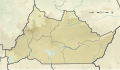 Adamawa region relief location map.svg 1,205 × 697; 1.92 MB
-
 Cameroon map Lambert-AEA topographic with regions-blank.svg 991 × 1,388; 4.86 MB
-
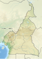
 Cameroon physical map.svg 852 × 1,226; 2.64 MB
-
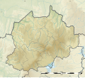
 Centre region relief location map.svg 1,016 × 1,064; 1.9 MB
-
 Chad River Basin relief.svg 531 × 511; 130 KB
-
 East region relief location map.svg 1,202 × 1,386; 2.42 MB
-
 Far North region relief location map.svg 945 × 1,166; 1.88 MB
-
 Littoral region relief location map.svg 804 × 929; 1.19 MB
-
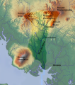 Mungo valley, Cameroon.svg 483 × 549; 752 KB
-
 North region relief location map.svg 1,181 × 1,156; 1.64 MB
-
 Northwest region relief location map.svg 1,111 × 1,010; 1.23 MB
-
 South region relief location map.svg 1,359 × 574; 1.22 MB
-
 Southwest region relief location map.svg 802 × 1,253; 1.55 MB
-
 West region relief location map.svg 1,116 × 1,073; 1.22 MB


