Category:SVG maps of Paraná
Jump to navigation
Jump to search
Media in category "SVG maps of Paraná"
The following 33 files are in this category, out of 33 total.
-
 Parana MesoMicroMunicip.svg 1,540 × 990; 854 KB
-
 Brazil Parana location map.svg 1,540 × 1,089; 767 KB
-
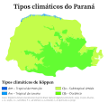 Clima do Paraná (Köppen).svg 512 × 486; 141 KB
-

-

-

-
 H1N1 Brazil PR map by confirmed deaths.svg 1,540 × 990; 83 KB
-
 Mapa de casos de COVID-19 no Paraná.svg 512 × 416; 868 KB
-
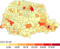
 Mapa de casos de COVID-19 por 100 mil habitantes no Paraná.svg 512 × 416; 868 KB
-
 Mapa do IDH do Paraná (2010).svg 512 × 352; 610 KB
-
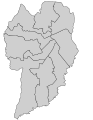
 Mapa dos bairros de Pinhais (SVG).svg 1,000 × 873; 16 KB
-
 Mapa SVG das Zonas eleitorais de Curitiba (1996).svg 612 × 792; 16 KB
-

-
 Parana DensidadePopulacional.svg 1,540 × 990; 856 KB
-
 Parana Meso MetropolitanadeCuritiba.svg 971 × 691; 804 KB
-
 Parana Municip Pinhais.svg 1,540 × 990; 854 KB
-
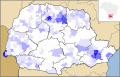
 Parana RM Apucarana.svg 1,540 × 990; 575 KB
-
 Parana RM CampoMourao.svg 1,540 × 990; 576 KB
-
 Parana RM Cascavel.svg 1,540 × 990; 575 KB
-
 Parana RM Maringa 2014.svg 1,540 × 990; 509 KB
-
 Parana RM Maringa.svg 1,540 × 990; 575 KB
-
 Parana RM Toledo.svg 1,540 × 990; 575 KB
-
 Parana RM.svg 1,540 × 990; 576 KB
-
 Paraná Köppen.svg 512 × 486; 133 KB
-
 Pinhais - Divisão administrativa (SVG - 2023).svg 993 × 907; 29 KB
-
 PR DensidadePopulacional.svg 1,540 × 990; 518 KB
-
 Região Intermediária de Cascavel, Paraná.svg 1,540 × 990; 17.71 MB
-
 Região Intermediária de Curitiba, Paraná.svg 1,540 × 990; 17.58 MB
-
 Região Intermediária de Guarapuava, Paraná.svg 1,540 × 990; 17.56 MB
-
 Região Intermediária de Londrina, Paraná.svg 1,540 × 990; 17.64 MB
-
 Região Intermediária de Maringá, Paraná.svg 1,540 × 990; 17.63 MB
-
 Região Intermediária de Ponta Grossa, Paraná.svg 1,540 × 990; 17.56 MB
-
 Regiões Geográficas do Estado do Paraná.svg 512 × 329; 8.64 MB


.svg)
.svg)
.svg)


.svg)
.svg)
.svg)
_-_2016.svg)


.svg)


