Category:SVG locator maps of countries of Africa (gray and green globe scheme)
Jump to navigation
Jump to search
Temperate regions: North America · South America · Africa · Europe · Asia · Oceania – Polar regions: – Other regions:

Countries of Africa: Algeria · Angola · Benin · Botswana · Burkina Faso · Burundi · Cameroon · Cape Verde · the Central African Republic ≈ Central African Republic · Chad · the Comoros ≈ Comoros · the Democratic Republic of the Congo ≈ Democratic Republic of the Congo · the Republic of the Congo ≈ Republic of the Congo · Djibouti · Egypt‡ · Equatorial Guinea · Eritrea · Eswatini · Ethiopia · Gabon · the Gambia ≈ Gambia · Ghana · Guinea · Guinea-Bissau · Ivory Coast · Kenya · Lesotho · Liberia · Libya · Madagascar · Malawi · Mali · Mauritania · Mauritius · Morocco · Mozambique · Namibia · Niger · Nigeria · Rwanda · São Tomé and Príncipe · Senegal · the Seychelles ≈ Seychelles · Sierra Leone · Somalia · South Africa · South Sudan · Sudan · Tanzania · Togo · Tunisia · Uganda · Zambia · Zimbabwe
Limited recognition: Ambazonia · Azawad · Puntland · the Sahrawi Arab Democratic Republic ≈ Sahrawi Arab Democratic Republic · Somaliland – Other areas: Bir Tawil · the Canary Islands ≈ Canary Islands · Ceuta · Madeira · Mayotte · Melilla · Réunion · Saint Helena, Ascension and Tristan da Cunha · the Scattered Islands in the Indian Ocean ≈ Scattered Islands in the Indian Ocean · Western Sahara
‡: partly located in Africa
Subcategories
This category has only the following subcategory.
Media in category "SVG locator maps of countries of Africa (gray and green globe scheme)"
The following 51 files are in this category, out of 51 total.
-

-
 Administered Western Sahara (orthographic projection).svg 650 × 650; 405 KB
-
 Africa (orthographic projection) blank.svg 512 × 512; 57 KB
-
 Africa (orthographic projection).svg 550 × 550; 111 KB
-
 Africa Burger King locations (orthographic projection).png 550 × 550; 95 KB
-
 African Union (orthographic projection).svg 549 × 549; 100 KB
-
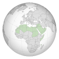
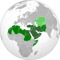
 Arab League (orthographic projection).svg 1,250 × 1,250; 313 KB
-
 Arab league orthographic NED 50m.svg 550 × 550; 350 KB
-
 Arab Maghreb Union (orthographic projection).svg 553 × 553; 255 KB
-
 Azawad (orthographic projection).svg 550 × 550; 290 KB
-
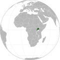
 Burundi (orthographic projection).svg 550 × 550; 183 KB
-
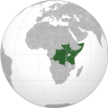
 COD orthographic.svg 550 × 550; 1.09 MB
-
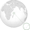
 Comoros (orthographic projection).svg 550 × 550; 185 KB
-
 Democratic Republic of the Congo (orthographic projection).svg 550 × 550; 164 KB
-
 EAF - no borders (orthographic projection).svg 550 × 550; 725 KB
-
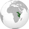
 East African Community (orthographic projection).svg 550 × 550; 179 KB
-
 East African Federation (orthographic projection).svg 550 × 550; 200 KB
-
 Gambia (orthographic projection with inset).svg 553 × 553; 250 KB
-
 Greater Middle East (orthographic projection).svg 551 × 550; 684 KB
-
 Greater Middle-East (orthographic projection).svg 550 × 550; 1.51 MB
-
 Guinea (orthographic projection).svg 550 × 550; 286 KB
-
 Kenya (orthographic projection).svg 550 × 550; 130 KB
-
 Latin Africa (orthographic projection).svg 550 × 550; 135 KB
-
 Liberia (orthographic projection).svg 550 × 550; 101 KB
-
 Malawi (orthographic projection).svg 550 × 550; 250 KB
-
 Mali (orthographic projection).svg 550 × 550; 83 KB
-
 Mali de iure (orthographic projection).svg 550 × 550; 103 KB
-
 Mauritania (orthographic projection).svg 550 × 550; 106 KB
-
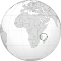
 Mauritius (orthographic projection).svg 550 × 550; 979 KB
-
 Mayotte (orthographic projection).svg 553 × 553; 240 KB
-
 MENA for Bridges across Cultures (orthographic projection).svg 550 × 550; 1.51 MB
-
 Middle East (orthographic projection without Turkey).svg 553 × 553; 328 KB
-
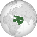 Middle East (orthographic projection).svg 553 × 553; 328 KB
-
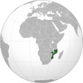 Mozambique (orthographic projection).svg 550 × 550; 306 KB
-
 Niger (orthographic projection).svg 550 × 550; 102 KB
-
 Nigeria (orthographic projection).svg 553 × 553; 218 KB
-
 North Africa (map).svg 794 × 1,123; 168 KB
-
 North Africa (orthographic projection).svg 733 × 733; 161 KB
-
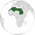
 Northern Africa (orthographic projection).svg 550 × 550; 167 KB
-
 Republic of the Congo (orthographic projection).svg 550 × 550; 283 KB
-
 Senegal (orthographic projection).svg 553 × 553; 222 KB
-
 Sierra Leone (orthographic projection).svg 550 × 550; 2.4 MB
-
 South Africa (orthographic projection).svg 550 × 550; 187 KB
-
 Spain WS-included (orthographic projection).svg 550 × 550; 232 KB
-
 SYC orthographic.svg 600 × 600; 1.18 MB
-
 Tunisia (orthographic projection).svg 550 × 550; 322 KB
-
 Tunisia location (orthographic projection).svg 553 × 553; 254 KB
-
 Uganda (orthographic projection).svg 550 × 550; 283 KB
-
 Western Africa (orthographic projection).svg 512 × 512; 145 KB
-
 Western Sahara (orthographic projection).svg 550 × 550; 145 KB
-
 Zimbabwe (orthographic projection).svg 550 × 550; 263 KB
_usato_da_FIAT_(e_fiat_chrysler_automobiles)_per_il_suo_mercato_automobili.svg)
.svg)
.svg)
.png)
.svg)
.svg)

.svg)
.svg)
.svg)

.svg)
.svg)
.svg)
.svg)
.svg)
.svg)
.svg)
.svg)
.svg)
.svg)
.svg)
.svg)
.svg)
.svg)
.svg)
.svg)
.svg)
.svg)
.svg)
.svg)
.svg)
.svg)
.svg)
.svg)
.svg)
.svg)
.svg)
.svg)
.svg)
.svg)
.svg)
.svg)

.svg)
.svg)
.svg)
.svg)
.svg)
.svg)
_blank.svg)
Categories:
- SVG locator maps of countries (gray and green globe scheme)
- SVG locator maps of countries of Africa (gray and green scheme)
- SVG locator maps of countries of Africa (gray globe scheme)
- SVG locator maps of Africa (gray and green globe scheme)
- Locator maps of countries of Africa (gray and green globe scheme)